

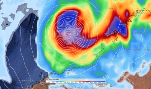
It’s all happening in West Australian weather right now, with Severe Tropical Cyclone Ilsa bearing down on the Kimberley and Pilbara while a strong cold front lurks southwest of Perth as WA sees a wintry chill down south. We’ve written lots about Ilsa this week and there will be plenty more to cover as it […]

Tropical Cyclone Ilsa has officially been declared, and is expected to intensify rapidly in coming hours and days, Just after 2 pm AWST, the BoM issued official notice that the tropical low it had been watching with interest for days had formed into a Category 1 cyclone, with sustained winds near the centre of 75 […]
A tropical cyclone is expected to develop near Australia this weekend and may make landfall along the north coast of WA mid-to-late next week. A tropical low formed on Wednesday night about 550km NNE of Darwin, above the warm tropical water of the Arafura Sea. While the low itself isn’t too impressive on satellite imagery […]

An outbreak of severe thunderstorms will affect parts of Qld, NSW, the ACT and Vic on Good Friday, with a chance of very dangerous supercells as people hit the roads for the long weekend. This Friday marks the start of the four-day Easter long weekend across Australia and the beginning of the school holidays for […]

Australia just had one of its warmest Marches on record as La Niña’s end brought drier and warmer weather to large parts of the country. Australia’s mean temperature last month was 1.11ºC above the 1961-1990 average, making it the nation’s equal 10th warmest March in 114 years of records. This late season-heat was most noticeable […]

Severe Tropical Cyclone Herman developed, reached a category 5 system and weakened all within the space of five days. The Bureau of Meteorology named Tropical Cyclone Herman at 8pm WST on Wednesday 29th. Within 36 hours of forming, it went from a category 1 system with winds exceeding 100km/h to a powerful category 5 system […]

A low pressure system located off the northwest coast of Australia is expected to become a tropical cyclone within the next 24 hours. The animation below shows a tropical low located near the Cocos-Keeling Islands on Wednesday morning. At 8am AWST, the centre of this low was roughly 380 km east of Cocos Island and […]

Rain will fall over large areas of every Australian state and territory this week as two northwest cloudbands sweep across the country. Northwest cloudbands are large bands of cloud that spread across Australia from the northwest towards the southeast. They are caused by moisture-laden air from the tropical Indian Ocean and typically produce widespread rain […]

Severe storms have ripped through Melbourne and Canberra on Thursday morning, delivering brief but heavy downpours in many suburbs, with the strong chance of more to come in both cities, as well as Sydney. The storms in Canberra and Melbourne struck just after 9 am, as you can see on the radar loop below which […]

Australia’s tropical cyclone season is officially underway, but we may not see much activity for few months yet. The season runs from November to April, and for mining operators and businesses across northern Australia, 2026-27 is shaping up to be a season where the headline numbers and the real risk may not line up. On […]

A positive Indian Ocean Dipole is underway, but this one is unlikely to deliver the textbook dry spring and summer that businesses have come to expect from the pattern. The Bureau of Meteorology officially declared a positive IOD on Tuesday, October 27, which typically like El Niño can cause drier and warmer conditions over parts of […]

Waters off Indonesia have cooled in recent weeks, an indication that a positive Indian Ocean Dipole (IOD) event could be developing. It’s an important climate driver for Australia, and it could shape rainfall and temperatures heading into summer, with flow-on effects for farmers, energy and other industries. What is the Indian Ocean Dipole? The IOD […]

Leonora, WA, had its wettest September day on record earlier this month. Three weeks later, more than 1.3 million lightning pulses were detected within 800 km of the town in 48 hours. Why is a stalled trough delivering storms to mining country, and what it could mean for operations? The DTN Total Lightning Network detected […]
