
Providing actionable insights for your business begins with understanding your unique attributes and industry. We dig deep to meet your requirements with our wealth of experience.
We opt for an evolutionary approach, something that grows with your enterprise as we continually push for innovative solutions to help you mitigate weather risk.
Our team would love to chat with you about the benefits of industry-leading forecasting and customisable systems.

One of Australia’s main climate drivers the IOD may be shifting into a phase that could impact the energy market, fire and emergency services and mining operators in the late winter and spring. What is the Indian Ocean Dipole? Australia’s weather is shaped by the seasons – cooler winters, warmer summers, and rainfall patterns that […]

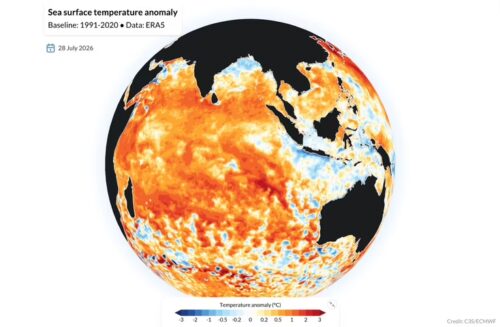
The 2026 El Niño has the potential to become one of the strongest on record, raising the likelihood of a warm and dry spring and summer across much of Australia. With the risk of elevated bushfire conditions later this year, fire and land management agencies are being urged to begin seasonal preparedness early. Potential record-breaking El Niño Beneath the surface of the tropical Pacific Ocean, a pool of abnormally […]

A positive Indian Ocean Dipole (IOD) could develop in the coming months, a signal mining and energy operators and fire agencies will want on their radar with it potentially increasing the likelihood of warm and dry weather over large areas of Australia in late winter and spring, with flow-on effects for water availability, dust/heat exposure, […]

For most of June, the Snowy Mountains looked like they’d skipped winter altogether. Now, 28 cm of fresh snow has fallen at Thredbo, providing a promising sign for the season’s eventual snowmelt contribution to hydropower. Thredbo in New South Wales was reporting 28 centimetres of snow overnight with snowfalls continuing this Friday morning, its nearby neighbour Perisher reported 25 cm, while Mt Hotham […]
