
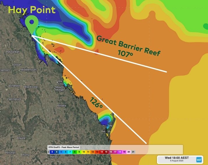
A powerful low pressure system off Australia’s East Coast in early August generated long period wave energy directed towards the coastline – some of which threaded under the Great Barrier Reef into Queensland’s Central Coast.
Easterly gales wrapping around the system between Sunday and Tuesday were around 1,000 nautical miles away from Hay Point, a major coal shipping port terminal near Mackay that services central Queensland mines. This stretch of Queensland’s coast only has a narrow “window” of about 20° into the Coral and Tasman seas, with either the Great Barrier Reef or Australia’s mainland “shadowing” most of the incoming swell energy.
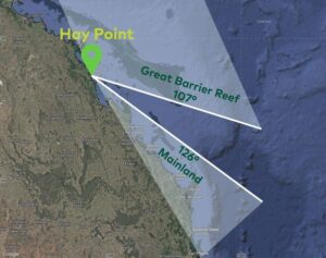
Image: Location of Hay Point and it’s swell “window” between the Great Barrier Reef and Australia’s mainland.
Typical Tasman Lows and East Coast Lows seen at this time of year usually form too far south for significant energy to wrap into this area of Queensland. However, this week’s low formed around 5° further north than usual, allowing this feed of wave producing winds to be angled precisely to thread into the region.
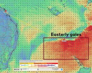
Image: Gales on the southern flank of the low on Tuesday, August 5, 2025.
Large seas of five to seven metres generated over the Tasman Sea and lower Coral Sea propagated east, impacting northern NSW and southeast Queensland severely, but also radiating across the East Coast. As the waves propagated east, the swell height decreased, and the period lengthened.
Video: DTN OneFX peak wave period across the northern Tasman Sea, Coral Sea and Central Queensland coast areas from Monday, to Friday, August 4-8, 2025.
Faint swell energy with wave periods of nearly 20 seconds started to be registered near Mackay on Sunday. From Monday, most of the wave energy had peak wave periods between 10 and 15 seconds.
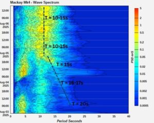
Image: Wave energy spectra from Sunday to Wednesday, August 3 to 6, 2025. Source: www.qld.gov.au
Why long period groundswells matter for port operations?
Huge seas hammering the coastline, like what impacted NSW and southeast Queensland earlier this week, obviously make shipping movements in and out of ports difficult. However, long period energy often goes unnoticed underneath ships, but surges into ports and harbours.
The “waves” of deep water energy surging into ports can cause ships to drag on their moorings and anchors. Seiching can also amplify this water movement as the energy sloshes within the port boundaries, increasing horizontal and vertical ship movements.
Using DTN APAC’s Operational Forecast Summary, central Queensland ports were warned over a week away from the arrival of the long period groundswell into the region, giving ample time to plan and alter operations around this week.

Image: DTN APAC Operational Forecast Summary showing increased groundswell risk this week in a simple, easy to understand, traffic light system.
How DTN APAC assists marine, ports and offshore industries
DTN APAC offers a comprehensive suite of services, refined through years of collaboration with the marine, ports and offshore industries, to optimise the safety and efficiency of your operations.
We work with you to understand your intrinsic operational challenges and customise high-precision forecasting, metocean and aviation services to your exact location and operational scope.
When working offshore, our solutions can underpin planning and safe execution for offshore oil and gas enterprises and wind farms. Our data can support your exploration, development, rig moving, shuttle tanker operations, and production and decommissioning phases. Whether your crews are on-site, being transported to shore, or diving to perform maintenance, we deliver tailored weather risk briefings to ensure you choose the optimal time to proceed.
DTN APAC’s trusted nowcasting and forecasting system, OpticastTM, allows you to rapidly respond to changing conditions offshore, en route and in port. We take your port topography and berth orientation into account, ensuring site-specific forecasts. For offshore oil & gas, wind farms, ports and logistics, we have your weather situational awareness covered, no matter where you are. We deliver real-time severe weather and lightning alerts to your team via your integrated dashboard: Portzone, and our Weatherguard app.
DTN APAC’s Total Lightning Network (TLN) ensures you avoid hours of unnecessary downtime by providing the most accurate technology in lightning detection and alerting. Safeguard your teams and assets with lighting and Dangerous Thunderstorm Alerts (DTAs), customised to your existing parameters and delivered in real-time across all devices in your network. You gain full spatial awareness of developing severe weather systems, allowing you to plan ahead and, where needed, execute your shutdown and evacuation procedures.
With extreme conditions slowing production and affecting infrastructure, safety and transport, trust us to deliver Australia’s most precise weather data and tailored insights, giving you decisive confidence when it’s most needed.
Learn more about our large range of industry leading products and services or email us at sales.apac@dtn.com




