
Prosper in a dynamic world
Search

Tropical Cyclone Ilsa expected to intensify rapidly

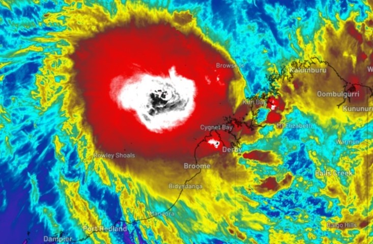
Tropical Cyclone Ilsa has officially been declared, and is expected to intensify rapidly in coming hours and days,

Just after 2 pm AWST, the BoM issued official notice that the tropical low it had been watching with interest for days had formed into a Category 1 cyclone, with sustained winds near the centre of 75 km/h and gusts to 100 km/h.

It was located approximately 400 kilometres NNW of Broome and 700 kilometres NNE of Port Hedland, moving SW at 13 km/h.

The Bureau also said:

  • TC Isla is expected to intensify further during Tuesday and Wednesday as it moves southwest, parallel to the Kimberley coast
  • There’s a significant risk it will become a severe tropical cyclone on Wednesday
  • It is expected to track to the S and then SE during Thursday, with a severe impact likely along the coast and adjacent inland areas between Port Hedland and Broome during late Thursday or early Friday
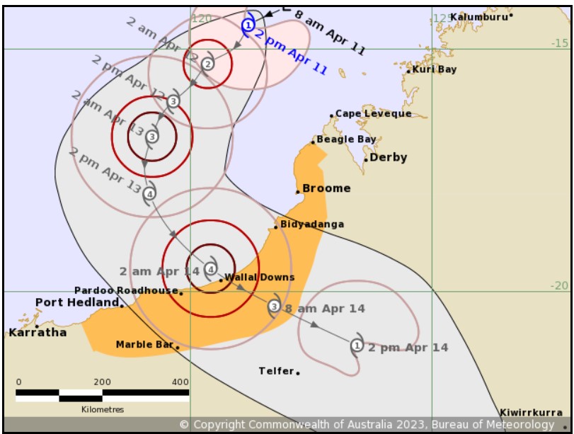
Image: As you can see, the cyclone is expected to be Cat 4 as it crosses the coast. That means sustained winds close to 200 km/h and gusts well over 200 km/h. Source: BoM.

The last cyclone originating in Australian waters to make landfall on the mainland was Cyclone Ellie on December 22, 2022.

While that storm’s winds didn’t cause widespread damage, the system was notable because of its persistence as a tropical low which delivered flooding rains far inland for weeks.

There are early indications that Ilsa could also bring heavy rains far inland, albeit to different parts of the interior. But before that happens, its immediate impacts on coastal communities and nearby areas could be far more severe.

DTN APAC provides detailed specific forecasts to clients when a tropical cyclone is expected to impact them. We provide detailed forecasts of wind, rainfall, and waves for you particular unique assets so you know what weather is headed your way. To find out more, please email us at apac.sales@dtn.com.

Latest news

Satisfy your weather obsession with these news headlines from around the nation, and the world.

Signs of a positive Indian Ocean Dipole, but it may not follow the textbook

Waters off Indonesia have cooled in recent weeks, an indication that a positive Indian Ocean Dipole (IOD) event could be developing. It’s an important climate driver for Australia, and it could shape rainfall and temperatures heading into summer, with flow-on effects for farmers, energy and other industries.  What is the Indian Ocean Dipole?  The IOD […]

1.3 million lightning strikes and a record September downpour: the storms testing WA’s Goldfields

Leonora, WA, had its wettest September day on record earlier this month. Three weeks later, more than 1.3 million lightning pulses were detected within 800 km of the town in 48 hours. Why is a stalled trough delivering storms to mining country, and what it could mean for operations?  The DTN Total Lightning Network detected […]

A very low wind power week, likely to continue

A stubborn blocking high over southern Australia will make for a very quiet week for wind generation and the pattern behind it isn’t a one-off.   It’s the seasonal signature of a super (very strong) El Niño combined with a positive Southern Annular Mode (SAM), and both the historical record and the current seasonal forecast suggest it’s likely to keep recurring through spring before a potential switch from November.  The setup right […]

Fastest strengthening El Niño on record: Impacts on Australian monsoon timing and wet season planning

Australia’s Mining and Resources sectors are bracing for a wet season shaped by one of the most rapidly developing El Niño events on record.    Looking back at how the strongest El Niño events in Australian history have played out, it becomes apparent that mining operations in Australia should be planning for a later monsoon […]


