

Relentless rain has fallen along parts of the NSW-Vic border during the past 24 hours, with Albury registering its wettest day since 1863. A near-stationary band of heavy rainfall developed along a convergence line in the Albury-Wodonga region of southern NSW and northeast Vic on Sunday night. This deluge, which was being fuelled by […]
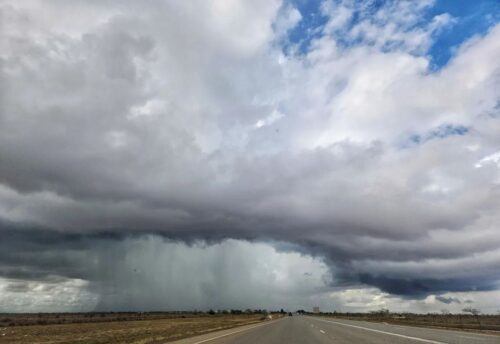
Port Hedland received a quick deluge on Sunday afternoon after a pair of thunderstorms converged over the region. Port Hedland picked up 45mm in the rain gauge, including 11mm in 10 minutes at about 2:30pm WST on Sunday afternoon. This was its heaviest January rain in 9 years, and its wettest day in 8 […]
A tropical cyclone is no longer forecast to hit the region, but tropical moisture will still lead to another thunderstorm outbreak over the coming week in the Pilbara. After a slow and slightly delayed start to the wet season, thunderstorms have since been a regular feature over the Pilbara region over the last 11 […]

Potentially severe thunderstorms could interrupt a warm Australia Day in Sydney and surrounding areas of central NSW this Thursday. A warm and mostly sunny morning will entice millions of people to head outdoors across the Greater Sydney region on the Australia Day public holiday this Thursday. Beaches will be bustling, parks will be packed, […]

Take a look at that satellite image showing an unusual green blob in the Red Centre of Australia. That, right there, is grass. Beautiful green, green grass and other vegetation. Now take a squiz at the same region about seven weeks earlier. See the difference? So why is the Red Centre so green? Rain, obviously, […]

Rain and thunderstorms will affect large areas of Australia this week as increasing tropical moisture feeds into several low pressure troughs across the country. The map below shows how much accumulated rain one computer model is predicting across Australia this week. Based on this model’s forecast, we are likely to see rain in part of […]
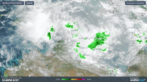
A tropical cyclone looks to form during the week and should make landfall over the Western Australian coast this weekend. A weak tropical low is currently just north of the Top End and is tracking to the west. While it will remain weak over the next few days, the monsoon is bringing rain and […]

The low pressure system that caused flooding in central QLD earlier this week could soon become a tropical cyclone over the Coral Sea. The sequence of satellite images below shows a tropical low located around 500 km to the east of the Qld coast this morning, near Willis Island. Earlier this week, this low helped […]

Heavy rain and storms lashed Victoria overnight, as a squall line crossed the state just after dark. We wrote an explainer story yesterday on squall lines, and it’s well worth reading so that you can understand exactly what’s going on in the graphic below, which shows a three-hour loop between 6:20 and 9:20 pm. Things […]

Australia’s tropical cyclone season is officially underway, but we may not see much activity for few months yet. The season runs from November to April, and for mining operators and businesses across northern Australia, 2026-27 is shaping up to be a season where the headline numbers and the real risk may not line up. On […]

A positive Indian Ocean Dipole is underway, but this one is unlikely to deliver the textbook dry spring and summer that businesses have come to expect from the pattern. The Bureau of Meteorology officially declared a positive IOD on Tuesday, October 27, which typically like El Niño can cause drier and warmer conditions over parts of […]

Waters off Indonesia have cooled in recent weeks, an indication that a positive Indian Ocean Dipole (IOD) event could be developing. It’s an important climate driver for Australia, and it could shape rainfall and temperatures heading into summer, with flow-on effects for farmers, energy and other industries. What is the Indian Ocean Dipole? The IOD […]

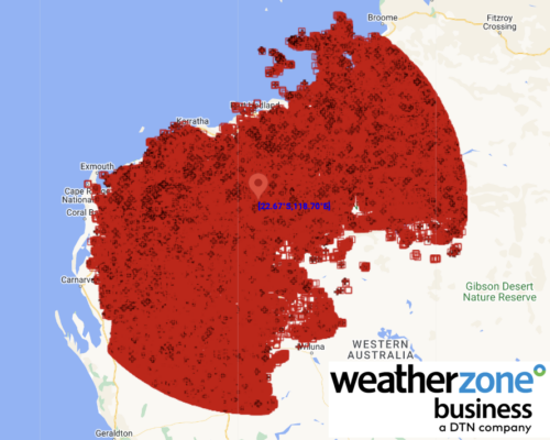
Leonora, WA, had its wettest September day on record earlier this month. Three weeks later, more than 1.3 million lightning pulses were detected within 800 km of the town in 48 hours. Why is a stalled trough delivering storms to mining country, and what it could mean for operations? The DTN Total Lightning Network detected […]
