Monsoon break continues but clouds are on the horizon
Another relatively settled week is on the cards for parts of northern Australia, but there are signs that heavy rain and thunderstorms could return in the second half of March. This temporary easing of heavy monsoonal rainfall comes as the monsoon trough moves north away from Australia. While showers and storms have moved over […]
Heavy rain and storms hitting QLD
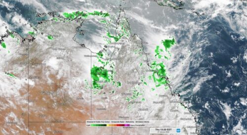
The heaviest rain in three to five years has already soaked parts of Queensland’s eastern tropical coast this week and more rain and storms will affect the state in the coming days. An active monsoon is causing copious moisture to flow over northern Queensland this week, resulting in widespread and heavy rain and thunderstorms. Image: Composite satellite, radar and lightning strikes on […]
Active storm week to be captured by Total Lightning Network
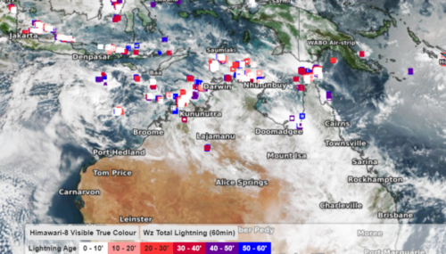
Australia set to see active thunderstorm week Australia is set to see a very active thunderstorm week as the monsoon trough deepens over northern QLD. During this week’s monsoon, severe thunderstorms are likely to impact parts of NT, northern WA and QLD. These storms have the potential to produce heavy rain, flooding, lightning and damaging wind in these regions. Visible satellite images and Weatherzone’s total […]
Tropical Cyclone Tiffany hits QLD, NT next in line
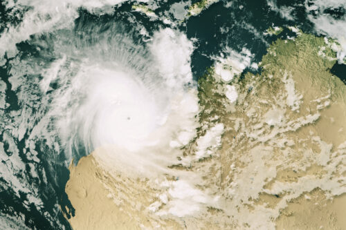
Tropical Cyclone Tiffany has made landfall over far north QLD and will soon be setting its sights on Groote Eylandt and the NT’s Top End. Tiffany became the fourth tropical cyclone to form in Australia’s area of responsibility when it was formed over the Coral Sea on Sunday afternoon. By 7am AEST on Monday, Tiffany had strengthened into a category two […]
Will Australia see another tropical cyclone in 2021?
There are early signs that tropical cyclone activity could pick up in the Australian region between Christmas and New Year’s Eve. We have already seen three tropical cyclones in the Australian region since the start of the cyclone season on November 1. Tropical Cyclone Paddy developed near Christmas Island in mid-November, which is several weeks earlier than usual […]
QLD miners alert: Heavy rain is on its way
Heavy rainfall and large multi-day rainfall totals are expected for parts of central and northeast QLD during the next 48 hours This rainfall is set to be triggered by a low-pressure trough, which will linger in the central interior for the next few days. Strong moist east to northeasterly winds will feed into this low-pressure trough, generating the rainfall event on Monday and Tuesday. Widespread 48 hour […]
Very very lightning, thunderstorms and mining
Thunderstorms are one of the most dangerous weather phenomena, which can occur at any time of the year in Australia. Lightning is random and can strike at any moment during a thunderstorm, posing a significant threat to mine sites. Mining trucks and vehicles in open areas may even attract lightning, whether they are stationary or not. If lightning […]
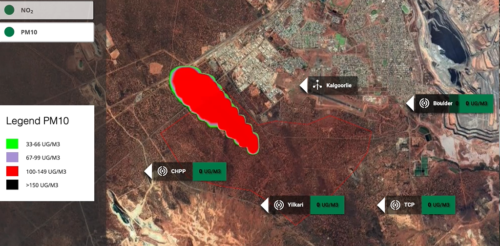
Explosive News – Weatherzone’s new Blast Dispersion System is the solution for your minesite
Mining blasting is the quickest, easiest, and cheapest way to remove rock and maximise production in open cut mining. However, there are many challenges that mine superintendents and blast managers face when considering a blast. Minimising environmental impacts and ensuring health and safety of miners is constantly a challenge when blasting for the superintendents. Information on weather conditions is paramount to minimise these risks to not only the mine site but also surrounding locations. Rainfall, wind, and inversion layers (the depth of atmospheric mixing) play a huge role in the […]
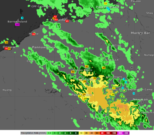
Is there a lack of radar coverage at your location? Oracle can help fill the gaps.
Radar coverage is sparse across regional Australia, much to the frustration of miners and local communities. This is because radars are typically placed near the coast, where much of Australia lives. Unfortunately, they can only detect rainfall within a 256 kilometre radius, leaving many areas without coverage. Significant rainfall was observed in the Pilbara […]