
Severe thunderstorms impacted southwest WA and the Perth region on Sunday, December 14, 2025, triggering Dangerous Thunderstorm Alerts (DTA) by DTN for industries and businesses in the region.
DTN operates Dangerous Thunderstorm Alerts (DTA) which alert businesses and industries to thunderstorms based on intensity and movement. These alerts provide advanced notice of thunderstorms moving into an area. The animated loop below shows DTAs in action over the Perth region on Sunday, as seen on DTN APAC’s Stormtracker dashboard.
Video: DTN APAC Stormtracker’s Radar, Dangerous Thunderstorm Alerts (DTA) and Total Lightning Network with severe thunderstorms moving over the Perth region on Sunday, December 14, 2025.
Three levels of thunderstorm alerting are provided by DTN: Level 1 (blue), Level 2 (yellow) and Dangerous Thunderstorm Alert (red). Alert levels are based on lightning frequency and density, and color-coded thunderstorm track polygons are provided to indicate the areas likely to be impacted in the next 30 minutes.

Image: DTN Level 1 and 2 thunderstorm alerts in action on Sunday, December 14, 2025.
Early warnings for thunderstorms can be incorporated into Trigger Action Response Plans (TARPs) for industries such as aviation, shipping, transport and utilities where lightning poses a serious risk to outdoor workers. Severe thunderstorms also pose a significant risk to expensive machinery with destructive wind gusts and large hail, bringing possible disruptions to the supply and industry chain resulting in costly insurance bills.
Thunderstorm activity started shortly after midday on Sunday, with powerful thunderstorms tracking south to southeast across the region. Between midday to midnight on Sunday, nearly 615,000 lightning strikes (over 135,000 recorded as ground strikes) were detected by DTN’s Total Lightning Network (TLN) across western WA.
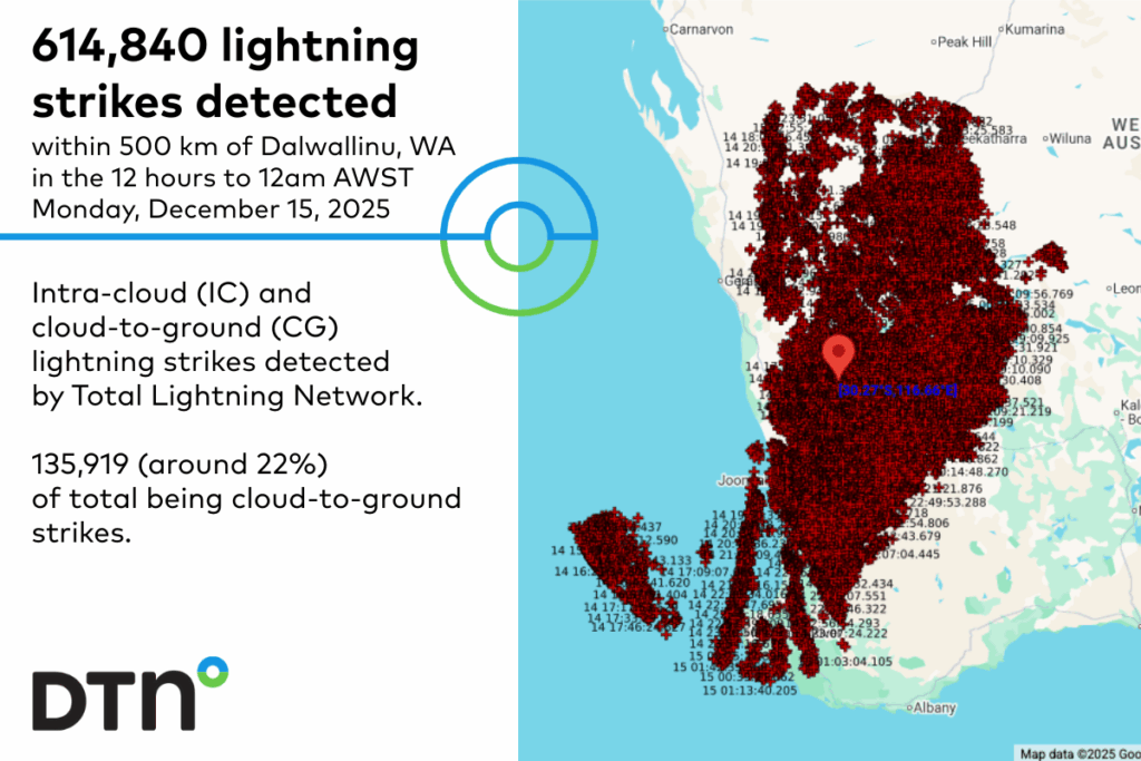
Image: DTN’s Total Lightning Network (TLN) detected a total of 614,840 lightning strikes within 500km of Dalwallinu between 12pm AWST Sunday, and 12am AWST Monday, December 15, 2025. Of the total lightning strike amount, 135,919 were recorded as ground strikes.
Notable wind gusts recorded with these severe thunderstorms include:
- 107 km/h at Ejanding at 3:38pm
- 100 km/h at Perth Airport at 4:03pm
- 94 km/h at Meekatharra and Pearce at 2:55pm and 4:10pm, respectively
- 92 km/h at Moora at 2:54pm
While storms remained active across the region throughout the afternoon and evening, most areas only received heavy rainfall for an hour or so, resulting in:
- 26mm at Long Pool in the hour to 3:50pm
- 17mm at Perth Ap (wettest December day in 14 years)
- 7mm at Dalwallinu (wettest December day in 13 years)
- The wettest December day in 8 years for Perth (15mm), Swanbourne (3mm), Pearce (14mm), Jandakot (6mm) and Bickley (13mm)
Damaging winds and flash flooding quickly moving over infrastructure with thunderstorms can catch operators off guard and unable to safely complete storm mitigation procedures.
How DTN APAC’s Total Lightning Network (TLN) and now-casting solutions are helping mining, transport, shipping and utility industries with severe thunderstorm warnings
Our Total Lightning Network is the intelligent lightning solution that goes above and beyond to alert lightning and increase your lead time before the storm hits.
We utilise a vast global sensor network, created with our partner Earth Networks. Over 1200 sensors in 40+ countries provide a worldwide view of both intra-cloud (IC) and cloud-to-ground (CG) lightning strikes, enabling businesses to plan and respond with the most precise insight available. The highest density of sensors across Australia and the globe give you the edge.
Real-time monitoring and alerting enhance safety outcomes whilst also preventing costly shutdowns caused by inaccurate sensor data. Our system provides early warning of approaching storms by tracking lightning activity, alerting you with the positive charge buildup that often precedes a strike, making it easier to detect potential threats.
Offering unsurpassed accuracy, with real-time sensing to <200m, we integrate with your existing systems to keep your enterprise operating within your defined severe weather thresholds. Our technology also helps monitor radiation from electrical discharges and ensures every lightning flash is accounted for.
Visualise approaching storms as our customisable GIS system, Stormtracker, plots strike data across your site and infrastructure. This enables enhanced understanding of the potential risk inherent in each severe weather system and how storms produce hazardous conditions. Integrated satellite technology improves tracking accuracy, while real-time weather forecasts provide deeper insights into developing thunderstorm activity and potential disruptions.
Leave nothing to chance. Be confident working outdoors with the most sophisticated lightning alerting system, delivering intelligence to any device across your business network. Whether you need a personal lightning alerting tool for individual safety or enterprise-wide monitoring, our solution is designed to emit timely alerts and protect your operations.
Learn more about our large range of industry leading products and services or email us at sales.apac@dtn.com




