
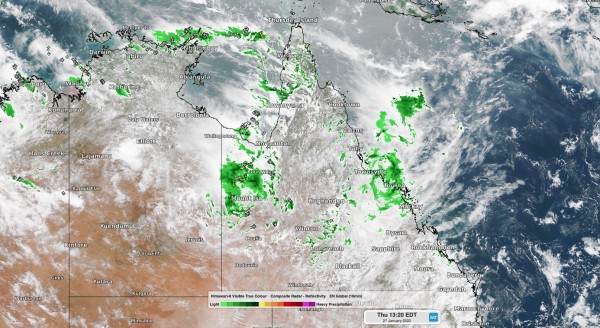
The heaviest rain in three to five years has already soaked parts of Queensland’s eastern tropical coast this week and more rain and storms will affect the state in the coming days. An active monsoon is causing copious moisture to flow over northern Queensland this week, resulting in widespread and heavy rain and thunderstorms.

Image: Composite satellite, radar and lightning strikes on Thursday afternoon.
During the 24 hours to 9am on Thursday, Bowen Airport collected 218.4 mm of rain, which was their heaviest daily fall in five years. About 208 mm of this fell in just 6 hours early on Thursday morning.
Further north, Townsville’s 172.2 mm during the 24 hours to 9am on Thursday was its heaviest rain in three years. Nearby, a rain gauge at Stoney Creek collected a whopping 528 mm during the 48 hours ending at 9am on Thursday.
This two-day deluge has left catchments in the area saturated and caused some flooding. As of 1pm AEST on Thursday, a severe weather warning remained in place for heavy rain between about Cardwell and Bowen, extending inland to about Charters Towers.
This heavy rain will migrate further north on Thursday night and on Friday, spreading over the state’s North Tropical Coast district and adjacent inland.
Six-hourly rates could reach 140 to 180 mm over parts of the Herbert and Lower Burdekin and North Tropical Coast Districts during Thursday into Friday. This much rain would be likely to cause areas of flash flooding and contribute to riverine flooding.
A flood watch has also been issued for several river catchments in eastern tropical Queensland due to this system.

Image: Forecast accumulated rain on Thursday and Friday, according to the ECMWF-HRES model.
This injection of tropical moisture will also help produce showers and thunderstorms in other parts of western and southern Queensland in the coming days. There are also indications that a tropical low may develop between Fiji and Vanuatu on the weekend. This system has the potential to move into the eastern Coral Sea on the weekend, possibly as a tropical cyclone.
At this stage, the low or cyclone is unlikely to directly impact Queensland, although it may move south and impact Lord Howe Island early next week. For more information on Weatherzone’s heavy rainfall alerts and tropical cyclone forecasting, please contact us at apac.sales@dtn.com.




