
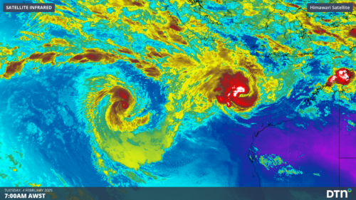
Two tropical cyclones have formed over the Indian Ocean to the northwest of Australia in the past 48 hours, with 75% of Australia’s cyclones so far this season becoming severe. The satellite image below shows that an eye has developed in both cyclones, with cloud swirling around it in a clockwise direction as the sun rises […]
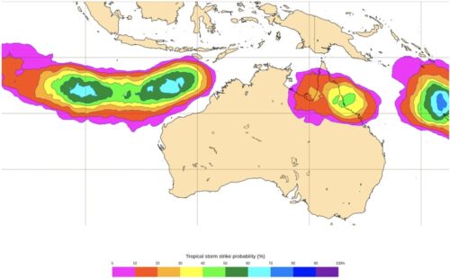
A tropical cyclone could form by early next week, with monsoon winds and tropical lows triggering the wet season and potentially impacting northern Australian businesses. The animation below shows widespread cloud around northern Australia on Friday. Within these vast areas of cloud are several areas of low pressure that have the potential to deepen and […]

Five tropical lows are forecast to form over the northern Australia waters this week, with an increased risk of heavy rainfall and tropical cyclone potential. The enhanced tropical activity comes as two giant tropical waves clash near Australia this week, called the Madden Julian Oscillation (MJO) and an equatorial Kelvin Wave. In addition to […]

A developing low pressure system off Australia’s northwest coast has a high chance of becoming a tropical cyclone this weekend, with the potential for heavy rain and wind to impact some mining and port clients in the Pilbara. Two separate areas of low pressure lying off the northern coast of WA are expected to consolidate […]

The long-awaited monsoon could finally develop over northern Australia towards the end of next week, increasing the risk of heavy rain, thunderstorms and tropical cyclones in the second half of January. Historically the monsoon arrives around late December on average, so its potential arrival next week is considered tardy. However, the latest monsoon onset at […]
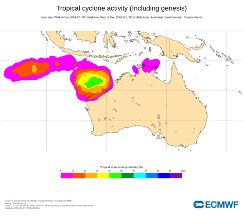
A pair of tropical cyclones may form to the northwest of Australia next week, with the potential for one to come close to the Pilbara and Kimberley coasts. Northern Australia faces an increased risk of heavy rain and tropical cyclone activity in the coming week thanks to the interaction of two huge atmospheric waves near […]

Australia should experience summer without the influence of major climate drivers like La Niña or a negative IOD, potentially heightening the risk of heatwaves, extreme heat and bushfires across parts of the country. Pacific Ocean climate driver During much of 2024, the sea surface temperatures across the central and eastern Pacific have been cooler than […]
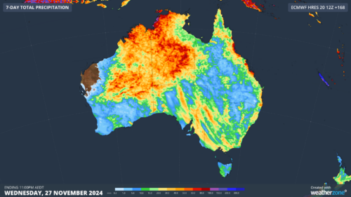
The Madden Julian Oscillation and the monsoon should impact Australia in the next fortnight, increasing the risk of heavy rain, flooding, thunderstorms and tropical cyclones in the coming weeks. The Madden-Julian Oscillation (MJO) is currently over the Indian ocean and is forecast to move east towards Australia in the coming days and remain in the […]
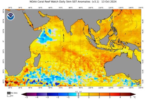
Sea surface temperatures in the Indian Ocean suggest that a negative phase of the Indian Ocean Dipole (IOD) may be emerging, which could influence Australian weather patterns in the coming months. What is the Indian Ocean Dipole? The IOD is an index that measures the difference in sea surface temperatures across the tropical Indian Ocean. […]

Australia’s tropical cyclone season is officially underway, but we may not see much activity for few months yet. The season runs from November to April, and for mining operators and businesses across northern Australia, 2026-27 is shaping up to be a season where the headline numbers and the real risk may not line up. On […]

A positive Indian Ocean Dipole is underway, but this one is unlikely to deliver the textbook dry spring and summer that businesses have come to expect from the pattern. The Bureau of Meteorology officially declared a positive IOD on Tuesday, October 27, which typically like El Niño can cause drier and warmer conditions over parts of […]

Waters off Indonesia have cooled in recent weeks, an indication that a positive Indian Ocean Dipole (IOD) event could be developing. It’s an important climate driver for Australia, and it could shape rainfall and temperatures heading into summer, with flow-on effects for farmers, energy and other industries. What is the Indian Ocean Dipole? The IOD […]

Leonora, WA, had its wettest September day on record earlier this month. Three weeks later, more than 1.3 million lightning pulses were detected within 800 km of the town in 48 hours. Why is a stalled trough delivering storms to mining country, and what it could mean for operations? The DTN Total Lightning Network detected […]
