

Tropical Cyclone Vernon has formed near the Cocos (Keeling) Islands and Anika could soon follow, much closer to mainland Australia. The satellite image below shows several blobs of cloud to the northwest of Australia. These clouds show areas of concentrated convective activity, or storminess, along a monsoon trough. Image: Enhanced visible/infrared satellite image captured at […]

The autumn bushfire outlook has been released by the National Council for Fire and Emergency Services, and as you’d expect given the wet, La Niña-influenced summer in the east, and the scorching WA summer, the outlook is very different on opposite sides of the country. Let’s run through some of the main points in relation […]

A tropical cyclone watch has been issued for Darwin as a low-pressure system gains strength in the Timor Sea. The satellite image below shows clouds building over the Timor Sea on Thursday, associated with a developing Tropical Low. Image: Enhanced visible/infrared satellite image showing cloud building around a developing tropical low to the west of […]

More than 120mm of rain during the last two days means Sydney is now having its wettest summer in 30 years. A persistent stream of moisture feeding into a slow-moving low-pressure trough caused 105.2mm of rain to fall in Sydney’s Observatory Hill rain gauge during the 24 hours to 9am on Wednesday. This was the […]

An overnight deluge has kicked off what is going to be a very wet four days in southeast Queensland and northeast NSW, with major flooding already occurring and likely to become more widespread in the coming days. A deep layer of moisture-laden air feeding into a low-pressure trough caused heavy rain and thunderstorms to develop […]
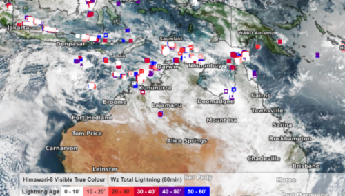
Australia set to see active thunderstorm week Australia is set to see a very active thunderstorm week as the monsoon trough deepens over northern QLD. During this week’s monsoon, severe thunderstorms are likely to impact parts of NT, northern WA and QLD. These storms have the potential to produce heavy rain, flooding, lightning and damaging wind in these regions. Visible satellite images and Weatherzone’s total […]

Tropical activity is set to increase across northern Australia, thanks to a pulse of cloud and rainfall called the Madden-Julian Oscillation (MJO) which is approaching the Australian region. This is expected to bring widespread rain and storms and an increased chance of tropical cyclones. Most models show a low developing in the waters south of […]

After nearly a week of heavy and persistent rainfall across NSW and QLD, locals may be wondering how that much rain can fall from the sky for that long? There are many ‘ingredients’ that worked together to generate some of the largest accumulated rainfall totals that NSW has seen in some locations for more than 100 years. Firstly, a low-pressure trough lingered off the NSW and QLD coast […]

Today we celebrate World Meteorological Day (March 23), with this year’s theme focusing on ‘The ocean, our climate and the weather’. It is also the beginning of the United Nations Decade of Ocean Science for Sustainable Development (2021-2030). Torrential rain in Sydney, flooding in regional New South Wales, extreme heat in Perth and northern Western Australia, and […]

Australia’s tropical cyclone season is officially underway, but we may not see much activity for few months yet. The season runs from November to April, and for mining operators and businesses across northern Australia, 2026-27 is shaping up to be a season where the headline numbers and the real risk may not line up. On […]

A positive Indian Ocean Dipole is underway, but this one is unlikely to deliver the textbook dry spring and summer that businesses have come to expect from the pattern. The Bureau of Meteorology officially declared a positive IOD on Tuesday, October 27, which typically like El Niño can cause drier and warmer conditions over parts of […]

Waters off Indonesia have cooled in recent weeks, an indication that a positive Indian Ocean Dipole (IOD) event could be developing. It’s an important climate driver for Australia, and it could shape rainfall and temperatures heading into summer, with flow-on effects for farmers, energy and other industries. What is the Indian Ocean Dipole? The IOD […]

Leonora, WA, had its wettest September day on record earlier this month. Three weeks later, more than 1.3 million lightning pulses were detected within 800 km of the town in 48 hours. Why is a stalled trough delivering storms to mining country, and what it could mean for operations? The DTN Total Lightning Network detected […]
