
After nearly a week of heavy and persistent rainfall across NSW and QLD, locals may be wondering how that much rain can fall from the sky for that long?
There are many ‘ingredients’ that worked together to generate some of the largest accumulated rainfall totals that NSW has seen in some locations for more than 100 years.
Firstly, a low-pressure trough lingered off the NSW and QLD coast for nearly a week.
For those that don’t know, a trough is an elongated area of low pressure (thinner air near the ground with air converging), which generates rising air, creating cloud, rain and, at times thunderstorms. With the trough remaining near stationary, showers and storms formed and moved over similar locations for days, one after the other, generating large totals. This is called the ‘train effect’.
But why did the trough of low pressure linger off the coast for nearly a week?
The trough remained near stationary due to a large blocking high pressure system over the Tasman Sea. This prevented the trough from continuing to move east, like the weather patterns usually do.
Given the position of the high-pressure system and low-pressure trough, the eastern coast of Australia saw humid easterly winds for days. The easterly winds hit the Great Dividing Range and are forced to lift, generating cloud and rainfall.
The easterly winds were more humid than normal because of the above average ocean temperatures off the eastern coastline. The east Australian Current that brings warm tropical waters south to NSW, feeding moisture into the atmosphere.
The atmosphere was also humid, due to tropical moisture feeding into our weather systems from northern Australia. All these factors led to heavy and persistent rainfall across NSW and QLD, with people wondering if they will ever see sun again.
So, just how much rain did fall?
The largest weekly totals in NSW were on and east the Great Dividing Range (Figure 1). However, to many farmers delight decent rainfall totals fell on the western slopes. Moree observed the heaviest rainfall in 26 years, with 150mm falling in 24 hours to 9am Tuesday, 23 March 2021.
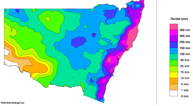
Figure 1: Weekly rainfall totals for NSW/ACT between 18/03/21– 24/03/21
The Mid North Coast, NSW, was the hardest hit during this event with Nambucca heads recording nearly a metre of rain (973mm) in 5 days, which is 6 times the monthly average for March.
Mount Seaview came close second recording 839mm in 6 days. The highest accumulated rainfall in 133 years was recorded at Wingham, Mid North Coast, NSW, of 570mm in a 5-day period.
Sydney did not escape the drenching with 307mm (Observatory Hill) falling in 6 days, Penrith’s 330mm the highest 6-day total since 1996.
The daily rainfall rates were also astounding with Kempsey recording the heaviest 24-hour total in 47 years, which was 226mm up to 9am Friday, 19 March 2021.
Weatherzone can forecast rainfall up to 15 days in advance, with its model Opticast, which alerted our meteorologists and clients early that this event was possible.
Opticast is continuously optimised in real time, and significantly outperforms single-model forecasts of cloud cover and rainfall (amongst over 30+ parameters). The forecasts update hourly based on real time observations, and the latest guidance from a suite of Numerical Weather Prediction models.
Forecasts are combined with confidence values, essential for making informed decisions in high-risk situations.
The Opticast suite of services’ proven track record guarantees your business the very best of short, medium and long-range forecasting services available.
Weatherzone also has flood warning systems and a synthetic radar system which effectively fills the gap in between radar coverage areas. Weatherzone’s radar is called Oracle and covers remote areas that are not covered by the BOMS radar, ensuring safety of remote communities. For more information, please contact us at business@weatherzone.com.




