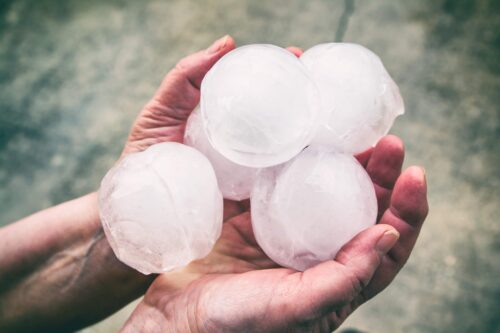
Hail events increasing in some Australian cities
Hailstorms are one of Australia’s most costly natural disasters. New research suggests that they are becoming more frequent in some of Australia’s cities. What is hail? Hailstones are made of layers of ice which form in thunderstorm updraughts. Hailstones grow larger by colliding with other rain droplets and ice particles in the updraft, until they […]
Is this heatwave a sign of things to come this summer?
Spring has kicked off with a sweltering heatwave in Australia, with the mercury soaring well above average in many states and territories this week. So, is this abnormal early-season heatwave a sign of what’s to come this summer? What is a heatwave? In Australia, a heatwave is defined as three or more days of unusually high […]
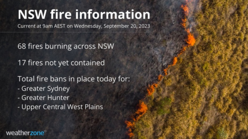
68 NSW fires burning, 17 unconfined
The heatwave continues in New South Wales, with summer-like temperatures and summer-like fire danger. On Thursday morning, there were 68 bushfires burning, 17 of them uncontained, as dangerous winds pick up strength ahead of a southerly change due later on Wednesday. The NSW Rural Fire Service has declared a total fire ban in three regions: […]
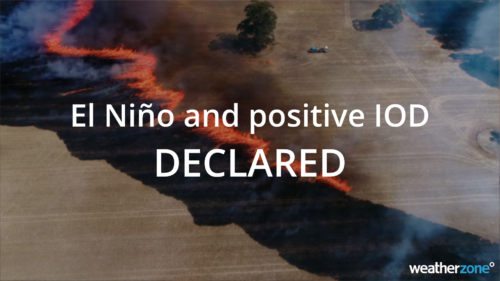
El Nino and positive IOD declared
The Bureau of Meteorology has today declared the arrival of El Niño and a positive Indian Ocean Dipole (IOD), a climate driver double-up that significantly increases the likelihood of unusually warm and dry weather across large areas of Australia in the second half of 2023. The Bureau made the El Niño and positive IOD declarations […]
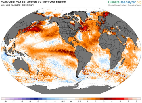
Monitoring El Nino in a warming climate
Scientists are developing a new way to classify El Niño in a warming climate as rising ocean temperatures make existing methods less effective. This research, led by a team of international scientists, may even shed light on why the atmosphere has struggled to respond to this year’s developing El Niño. Warm, warm water in […]
Is the northern wet season nearly here?
Northern Australia’s wet season is about to begin, with relentless humidity and heat, regular storm activity, monsoonal rains, and possible cyclone activity on the horizon. So, when will this year’s wet season arrive? Northern Australia’s wet season officially runs from October to April. The first few months are called the build-up, when moisture builds […]
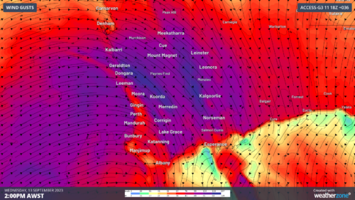
Powerful cold front approaching WA
A powerful cold front is approaching WA, and will generate a wild mix of record warmth, extreme fire danger, 100km/h winds, severe thunderstorms, and heavy rain across the state on Wednesday. Record heat Ahead of this front, heat has been building over WA over the last few days. Last night that heat produced the hottest […]
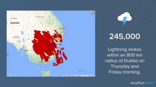
Total Lightning Network detected 245,000 lightning strikes in 24 hours
An outbreak of early-spring thunderstorms has caused prolific lightning over Australia’s southeastern states during the last 24 hours. The animation below shows lightning spreading across central and southeastern Australia on Thursday and Friday morning. These storms were triggered by a large pool of cold air from the Southern Ocean clashing with much warmer air […]
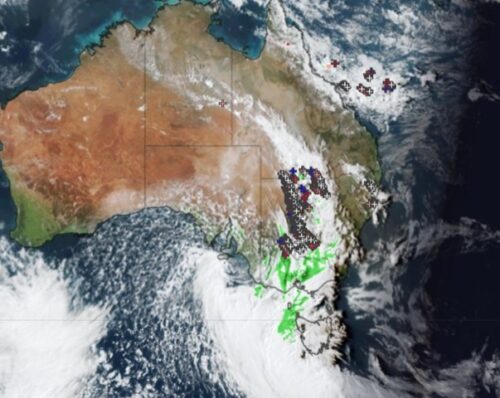
Enormous line of storms crossing three states
The strong early spring cold front continues its march across eastern Australia, generating wild winds and a huge line of storms stretching from southern Qld, all the way through NSW, and into Victoria. No notable rainfall totals have been reported yet with this system in NSW or Vic as it’s moving pretty quickly and tending […]