

Spring has kicked off with a sweltering heatwave in Australia, with the mercury soaring well above average in many states and territories this week. So, is this abnormal early-season heatwave a sign of what’s to come this summer?
What is a heatwave?
In Australia, a heatwave is defined as three or more days of unusually high day and nighttime temperatures in an area.
While hot days can be uncomfortable on their own, the combination of abnormal heat during both day and night can significantly increase stress on the human body.
High overnight temperatures also give the daytime heating a head start, which can allow the mercury to reach uncomfortable levels early in the day and increase into the afternoon. This is why heatwaves typically cause increased air conditioner to use and energy demand during both the day and night.
The Bureau of Meteorology (BOM) assesses heatwave risk by taking the forecast maximum and minimum temperatures for a three-day period and comparing it to the average temperature for the time of year, and the observed temperatures during the last 30 days.
How do heatwaves impact people and businesses?
Heatwaves are responsible for more deaths in Australia than any other natural hazard, including bushfires, tropical cyclones, and floods.
The Bureau’s national heatwave service is classified into three levels based on intensity:
- Low intensity heatwaves are common in summer and most people can cope with them
- Severe heatwaves are challenging for vulnerable people and are less frequent
- Extreme heatwaves can affect healthy people, particularly those that work outdoors, and are rare
The map below shows that the Bureau of Meteorology was forecasting a severe heatwave for parts of the south coast earlier this week.
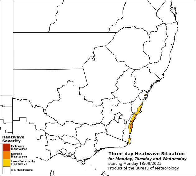
Image: Three-day heatwave situation for Monday, Tuesday and Wednesday, September 20, Source:BOM
According to the World Health Organisation (WHO), 166 000 people died worldwide due to heatwaves between 1998-2017.
In addition to people’s health, heatwaves also impact infrastructure, power and water supplies, transport, healthcare, emergency services, agricultural and bushfire risk.
The increased use of air conditioners in homes and business over recent decades has placed a significant demand on the electricity system in periods of extended hot weather. Heatwaves have the biggest impact when they impact multiple states and territories at the same time, with little energy able to be shared, causing blackouts.
Heatwaves can also cause train disruptions, increased pressure on water supply, agricultural damage and increase bushfire risk.
What causes a heatwave?
While heatwaves are more common in summer, they can occur in spring like we have seen this week. Heatwaves occur when a hot airmass lingers over a region for several days and nights, often caused by a slow or stationary blocking high-pressure system near southern Australia. Other climate influences can exacerbate extreme high temperatures in Australia, including El Niño, a positive Indian Ocean Dipole (IOS), drought, and climate change.
Heatwave forecast for spring and summer
El Niño and a positive IOD are currently underway. This climate driver double-up will significantly increase the likelihood of unusually warm and dry weather across large areas of Australia in the second half of 2023 and early 2024.
While El Niño is known to increase the risk of extreme heat across southern Australia, multi day heatwaves are less common under its influence. This is because weather systems tend to sweep across southern Australia more quickly during El Niño years, reducing the likelihood of stubborn high-pressure systems that sit over southern Australia causing heatwaves.
However, Australia’s north is set to swelter this summer with above average heatwaves and extreme heat both on the cards.
How can Weatherzone help?
The shifting climate is bringing increased complexity and greater risks to businesses worldwide. We are here for you, delivering trusted weather solutions to optimise your operations and profitability.
DTN APAC is a diverse team, with global forecasting, product development and analytics expertise. Couple this with extensive industry experience spanning Aviation to Energy, and we are primed to assist you in strengthening your response to weather
impact.
We work hard to identify your operational pressures and tailor our services and products to meet your needs. Concise communication, giving you full situational awareness exactly when you need it, is our focus. We want to reduce weather risk in your operations, every day.
We deliver clear and comprehensive weather data, personalised risk assessments and briefings to you and your team, so that your critical decisions can be made with confidence.
We are available 365 days a year, so you always have the timely guidance you require, especially when severe conditions hit.
You have our insights to rely on to see you through complex situations, minimising potential loss of profit and maximising the safety of your staff and assets. For more information, please contact us at apac.sales@dtn.com.




