Is another tropical cyclone coming to Qld?
Some weather models are hinting at the possibility of yet another tropical cyclone, after Jasper and Kirrily, to develop in the Coral Sea and make landfall over the Queensland coast. But how likely is this to happen at this stage? Thumbnail image: Severe Tropical Cyclone Kirrily at landfall. Source: Cooperative Institute for Research in the Atmosphere […]
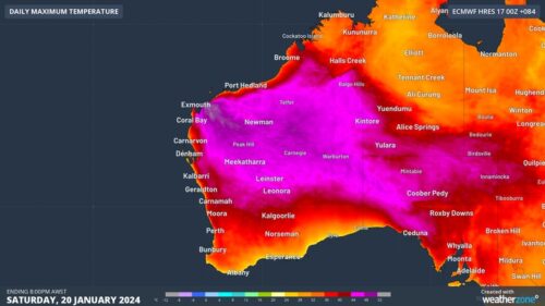
Another day, another Perth sizzler
Be grateful if you’re lucky enough to be working indoors in air conditioning for the rest of the working week in Perth, as temps are set to keep sizzling until the weekend. This Wednesday is day two of a four-day heatwave in western and southwestern WA, with Perth heading for a top of 39°C this […]
Tropical Cyclone Kirrily declared, will cross Qld coast Thursday evening
Tropical Cyclone Kirrily was declared on Wednesday evening and will cross the Queensland coast on Thursday evening. The most likely time of landfall is around 8 pm AEST, although it could occur anytime between about 6 pm and midnight. The most likely location for landfall is just north of Townsville around Magnetic Island although the […]
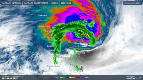
Tropical Cyclone Kirrily struggling to develop over Coral Sea
Despite the unexpectedly sluggish development of a tropical low over the Coral Sea, a tropical cyclone named Kirrily is still expected to hit the east coast of Qld tomorrow night. A tropical low has been spinning over the central and eastern Coral Sea over the last few days, threatening to become a tropical cyclone. However, […]
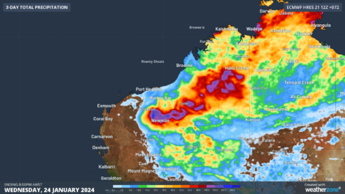
Heavy rain and storms loom for Pilbara
A tropical low will cause heavy rain and thunderstorms across northwestern Australia later this week, with flooding possible in parts of the Pilbara. A slow-moving tropical low has caused persistent rain over parts of the NT during the past on to two, producing several hundred millimetres in some areas. Elliot’s 433 mm during the […]
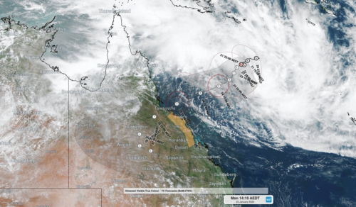
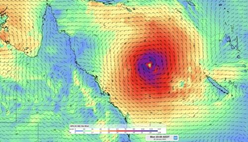
Queensland bracing for severe tropical cyclone impact
A severe tropical cyclone could hit eastern Queensland later this week, bringing a risk of heavy rain, flooding, destructive winds and a dangerous storm tide. At 10am AEST on Monday, January 22, a tropical low was located over the central Coral Sea, roughly 860 km to the east northeast of Townsville. Image: Visible true-colour satellite […]
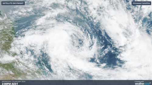
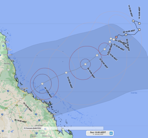
Tropical Cyclone Kirrily headed for Qld
A tropical low, soon to be named Tropical Cyclone Kirrily, is expected to make landfall over Queensland this week as a category 3 strength system. At 11am AEST Sunday, Tropical Low 05U was about 940 km east northeast of Townsville, with wind gusts up to 85km/h and was slow-moving. This large mass of swirling cloud […]
Extreme heat imminent for Pilbara, 50C possible
The presence of multiple tropical lows in the Australian region could cause a burst of intense heat over the Pilbara this weekend and early next week, with temperatures possibly exceeding 50ºC in some areas. Northwestern Australia is always hot in early summer as temperatures soar amid abundant pre-monsoon sunshine. The mercury frequently reaches the mid-forties […]
High chance of Coral Sea tropical cyclone next week
A developing tropical low over the Coral Sea could become a tropical cyclone by the start of next week, continuing the region’s active start to the 2023-24 tropical cyclone season. It’s been just over a month since Tropical Cyclone Jasper made landfall along Queensland’s North Tropical Coast, bringing torrential rain and major flooding across the […]