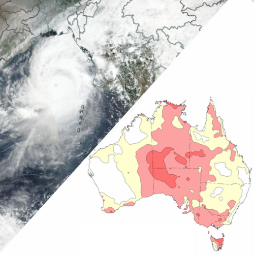
Cyclone Mocha could lead to a hot dry spring in Australia
Tropical Cyclone Mocha, which devastated Myanmar and Bangladesh earlier this month, may have set off a chain-reaction in the Indian Ocean Dipole that will lead to a hot, dry spring in Australia this year. Tropical Cyclone Mocha was a powerful system that formed in the northeastern Indian Ocean, over the Bay of Bengal, on May […]
Southern Oscillation Index hits El Nino threshold
A key atmospheric indicator in the Pacific Ocean region has just surpassed the accepted threshold for El Niño, increasing the likelihood of abnormally dry and warm weather in Australia later this year. There has been a lot of talk recently about the potential for a strong El Niño in 2023. Most of this climate driver […]
Southern Annular Mode hits near-record level
The Southern Annular Mode (SAM) – one of the main broad-scale mechanisms influencing Australia’s climate – just reached one if its strongest positive levels on record. What is the SAM? The SAM refers to the north-south displacement of the powerful westerly wind belt that flows around Antarctica throughout the year. These westerly winds carry the […]
Atmosphere holding back El Nino outlook
Despite the ocean giving clear signs that El Niño could form later this year, a lack of feedback from the atmosphere is giving forecasters a reason to be cautious in their outlook. An abrupt period of warming across the equatorial Pacific Ocean has seen an El Niño-like pattern of sea-surface-temperature anomalies emerging in recent months. […]
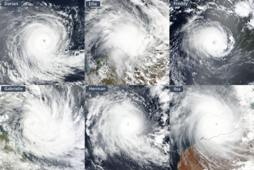
Australia’s 2022-23 tropical cyclone season wrap-up
Australia just had an unusually strong tropical cyclone season, despite having only six systems named inside Australia’s area of responsibility. The 2022-23 Australian tropical cyclone season officially ran from November 1, 2022, until April 30, 2023. During this six-month period, the Bureau of Meteorology assigned names to six tropical cyclones that formed inside Australia’s area […]
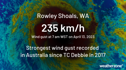
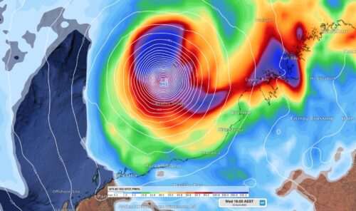
Cyclone Ilsa unleashes 235 km/h winds
Tropical Cyclone Ilsa continues to intensify on Thursday morning, with a wind gust of 235 km/h recorded at 7am Rowley Shoals, a trio of tiny coral atolls located 300 km west of Broome. This is the strongest wind gust recorded anywhere in Australia since TC Debbie in 2017 Ilsa is now a Category 4 cyclone […]
Growing tropical cyclone threat for WA next week
A tropical cyclone is expected to develop near Australia this weekend and may make landfall along the north coast of WA mid-to-late next week. A tropical low formed on Wednesday night about 550km NNE of Darwin, above the warm tropical water of the Arafura Sea. While the low itself isn’t too impressive on satellite imagery […]
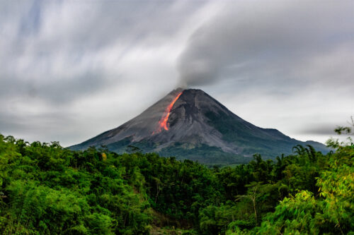
How an ash cloud mirrors mining blasts
On Saturday, Indonesia’s most active volcano, Mount Merapi, erupted, sending huge plumes of ash into the sky. It serves as a large-scale reminder of how ash and dust from explosions, including in mining and demolition, can travel and spread. Mount Merapi erupted at 5am UTC (1pm WST) on Saturday afternoon. Most notable was a […]
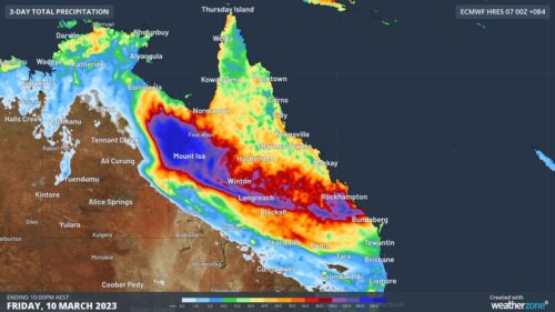
Queensland deluge to bring outback flooding, road closures
A surge of tropical moisture will produce heavy rain and thunderstorms in parts of northwest and central Queensland during the next several days, likely causing flooding and road closures in parts of the state. A slow-moving tropical low pressure system will help drag copious moisture across Qld from the northwest in the coming days. The […]