Prosper in a dynamic world
Search

Could we see a tropical cyclone next week?

  There are early indications that a tropical cyclone could form near the Solomon Islands next week, with some forecast models suggesting the system could briefly enter Australia’s area of responsibility. Australia’s official tropical cyclone season runs from November until April. During this 6-month period, we typically see around 9 to 10 tropical cyclones forming […]

How wind changes grow bushfires

Winds are a key component to understanding the behaviour of bushfires. But what happens when the wind suddenly changes direction? Typically, a fire will tend to spread along the same direction as the prevailing winds. In a strong wind, this allows the fire front to follow the wind very quickly and can exceed 50km/h in […]

Positive IOD keeps getting stronger

This year’s positive Indian Ocean Dipole is gaining strength so quickly that it’s getting close to the record-challenging 2019 event that underpinned Australia’s warmest and driest year on record. While the Pacific Ocean’s El Niño has been getting a lot of attention in recent months, its lesser-known cousin – the Indian Ocean Dipole (IOD) – […]

Australia’s 2023-24 tropical cyclone season outlook

  Australia’s tropical cyclone season will be affected by one of the strongest El Niño events in recent decades. So, how many tropical cyclones will Australia see this season?  Australia’s official tropical cyclone season runs from November until April. While tropical cyclones can form in or near the Australian region at any time of year, […]

Hector the convector’s first appearance off Darwin this season

  One of the world’s most consistent thunderstorms developed for the first time this season, signalling that the ‘build up’ across the north has begun.  The image below shows the famous thunderstorm developing to Darwin’s north on Thursday afternoon.   Image: Himawari satellite image at 3:15pm on Thursday, October 5.  Nearly every afternoon the thunderstorm forms […]

Australia’s driest September on record, one of the hottest too

Australia has had its driest September on record, led by huge rainfall deficiencies in the Murray-Darling Basin. Most of the country was well above average for maximums too, with NSW, Victoria and WA setting new records. Rainfall Australia as a whole averaged a measly 4.8mm of rain during September, the lowest on record for September […]

Severe thunderstorms hitting eastern Australia

Thunderstorms have developed in southeast Qld and northeast NSW on Thursday, bringing a risk of heavy rainfall to the region. The storms are being triggered on a southerly change which is moving up the Qld coast on Thursday afternoon. The video below shows the storms moving slowly across the region. On Wednesday night, over half […]

Geraldton’s hottest September day in more than a century of records

It was Geraldton’s hottest September day in more than a century. Temperature records are being broken in WA today as a searing air mass spreads across the state’s north and west. A high pressure system centred over the Great Australian Bight is causing a pool of hot air to intensify over northwestern Australia, with temperatures […]

Positive Indian Ocean Dipole (IOD) strengthening

A positive Indian Ocean Dipole (IOD) event is gaining strength to the northwest of Australia, increasing the risk of hot and dry weather and fires in the coming months. What is the IOD? The IOD is an index that measures the difference in sea surface temperature anomalies between the western and eastern sides of the […]

Latest news

Satisfy your weather obsession with these news headlines from around the nation, and the world.

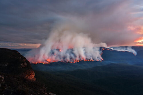
How does DTN help businesses monitor bushfire induced pyrocumulonimbus thunderstorms that ignite more fires?

Intense heat from bushfires during elevated fire danger days can trigger fire-induced pyrocumulonimbus thunderstorms that ignite additional fires. In early January 2026, an extreme heatwave sweeping over southeastern Australia brought catastrophic fire danger to Victoria. Intensely hot bush and grass fires spread erratically and quickly in hot, dry and gusty winds, with pyrocumulonimbus generating lightning, […]

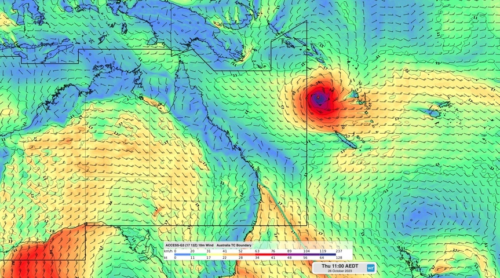
Active seas to the north and east of Australia disrupting port and maritime operations

Seas to the north and east of Australia are experiencing periods of increased activity this week, leading to disruptions to port, maritime and offshore operations. Intense and hazardous Tasman Sea Ocean conditions across NSW’s South Coast rapidly deteriorated last Friday as a deep feed of easterly winds whipped up large and dangerous seas. The Batemans […]

Transport, emergency and energy industries flooded across Greater Sydney with weekend deluges

Transport, emergency, energy and port industries in eastern NSW and Sydney were impacted by significant flash flooding with intense and heavy rainfall this weekend. Rainfall rates between 80 and 140mm in one to three hours were registered across parts of Sydney’s Northern Beaches and Central Coast on Saturday afternoon and evening. In some areas, these […]

DTN Dangerous Thunderstorm Alerts in action with severe thunderstorms disrupting Perth industries

Severe thunderstorms impacted southwest WA and the Perth region on Sunday, December 14, 2025, triggering Dangerous Thunderstorm Alerts (DTA) by DTN for industries and businesses in the region. DTN operates Dangerous Thunderstorm Alerts (DTA) which alert businesses and industries to thunderstorms based on intensity and movement. These alerts provide advanced notice of thunderstorms moving into […]