
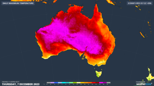
Our capital cities should dodge the worst of it, but the first heatwave of the 2023/24 summer will affect huge parts of the country this week, having already warmed up parts of WA over the weekend. The pink zone on the map below shows areas that can expect maximum temperatures of 44°C or higher […]
Australia has entered summer 2023-24 under the influence of a moderate El Niño and a positive Indian Ocean Dipole. So how will these climate drivers influence Australia’s weather throughout the season and what can you expect to see in your part of the country during the next three months? Climate drivers this season The […]

Large areas of the country are at an increased risk of bushfires this summer, with several dry-phase climate drivers impacting the outlook. The Australasian Fire and Emergency Service Authorities Council (AFAC) has today released Australia’s official Seasonal Bushfire Outlook for summer. The outlook brings together advice and information from AFAC, the Bureau of Meteorology […]

A broad arc of dangerous thunderstorms is moving over eastern Australia this afternoon, prompting severe storm warnings from central Qld to southern NSW. The animation below shows the massive band of storms, which has formed ahead of an approaching upper-level trough associated with an upper-level low centred over southern NSW. At one stage on Wednesday […]

Extremely heavy and in some cases record-breaking rain has fallen across New South Wales in the 24 hours to 9 am Wednesday, with 351 mm falling at one South Coast location. This truly was a remarkable 24 hours of rainfall, and not just because of the massive totals in many areas, but because of […]

Parts of Australia are having one of their wettest Novembers on record during El Niño. This is a juxtaposition that may seem surprising, but it is actually a timely reminder of Australia’s fickle relationship with broad-scale climate drivers. El Niño has been in the news a lot this year since it was initially declared by […]

Parts of Tasmania had one of their driest summers on record last year, so what is in store for hydro power this summer? The western half of Tasmania saw summer totals in the driest 10% of records in 2022-23, under the influence of La Niña and a positive Southern Annular Mode (SAM). These climate […]
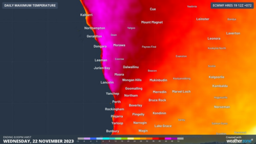
There’s nothing too unusual about a burst of heat for Perth and nearby areas with summer almost upon us, but this week’s heat will be intense by November standards. On Monday afternoon, the BoM issued heatwave warnings for numerous WA forecast regions, with a three-day heatwave warning in effect in a broad strip in […]

Australia has some of the best offshore wind resources in the world, which are set to be captured by facilities scattered across our vast coastline in several years time. The offshore wind industry is booming internationally, as countries around the globe use it as part of their renewable energy transition. Wind farms are […]

Australia’s tropical cyclone season is officially underway, but we may not see much activity for few months yet. The season runs from November to April, and for mining operators and businesses across northern Australia, 2026-27 is shaping up to be a season where the headline numbers and the real risk may not line up. On […]

A positive Indian Ocean Dipole is underway, but this one is unlikely to deliver the textbook dry spring and summer that businesses have come to expect from the pattern. The Bureau of Meteorology officially declared a positive IOD on Tuesday, October 27, which typically like El Niño can cause drier and warmer conditions over parts of […]

Waters off Indonesia have cooled in recent weeks, an indication that a positive Indian Ocean Dipole (IOD) event could be developing. It’s an important climate driver for Australia, and it could shape rainfall and temperatures heading into summer, with flow-on effects for farmers, energy and other industries. What is the Indian Ocean Dipole? The IOD […]

Leonora, WA, had its wettest September day on record earlier this month. Three weeks later, more than 1.3 million lightning pulses were detected within 800 km of the town in 48 hours. Why is a stalled trough delivering storms to mining country, and what it could mean for operations? The DTN Total Lightning Network detected […]
