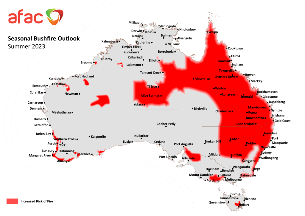
Large areas of the country are at an increased risk of bushfires this summer, with several dry-phase climate drivers impacting the outlook.
The Australasian Fire and Emergency Service Authorities Council (AFAC) has today released Australia’s official Seasonal Bushfire Outlook for summer. The outlook brings together advice and information from AFAC, the Bureau of Meteorology and Australia’s state and territory fire authorities.
According to the outlook, there is an increased risk of fires in large areas of Qld and NSW, and parts of the NT, VIC, SA, WA and TAS
This outlook is being influenced by several factors:
- Three consecutive La Nina years brought wet conditions that caused prolific vegetation growth in some areas of the country.
- This vegetation is now drying out and becoming very flammable on the back of a record-breaking dry start to spring, combined with unusually warm temperatures.
- A confluence of dry phase climate drivers, including El Niño, a positive Indian Ocean Dipole (IOD) and the potential for negative Southern Annular Mode (SAM) phases early in 2024.
- These climate drivers will make abnormally hot and dry conditions more likely in some regions of Australia this summer.
- Some of the vegetation affected by the 2019/20 black summer fires has also regrown and is now able to carry fast moving fires.
The ACT is the only state or territory that has a normal fire risk this summer, with the territory expecting near-average rainfall this summer.
Parts of eastern Australia were fortunate to see increased rainfall and thunderstorm activity in November, which has helped replenish root zone soil moisture in parts of Qld, NSW and Vic. While this recent bout of wet weather will help mitigate fires at the start of summer, most of NSW and Qld are forecast to see an increased risk of fire in the mid to late summer due to above average temperatures and ongoing drying of vegetation.
AFAC CEO Rob Webb says that “an increased risk of bushfire makes it even more important for you to take action. Wherever you live, work or visit this summer, know where to find bushfire information, prepare your property, and talk to your family and friends about what you will do in an emergency. Your local fire agency is the perfect place to find out exactly how to stay safe this summer.”
You can find the full Seasonal Bushfire Outlook for summer 2023-24 on the AFAC website.
DTN APAC serves the forestry and emergency sectors, delivering trusted weather data and severe weather alerting to maintain safety, protect your assets and underpin your planning.
Weatherzone’s trusted nowcasting and forecasting system, OpticastTM, is independently proven to outperform other industry models, allowing you to respond rapidly to changing conditions. Opticast can ingest data from your on-site weather observation equipment, ensuring your forecast is customised to your local microclimate. From nowcasting and 14 day forecasting to seasonal outlooks, you have powerful, hyper-local weather alerting and intelligence, giving you decisive confidence when it’s most needed.
With lightning a prominent cause of forest fires throughout Australia, Weatherzone’s Total Lightning Network offers real-time detection and unsurpassed accuracy of lightning strikes to <200m. Based on a vast sensor network, both intra-cloud and cloud-to-ground strikes are located, ensuring you are alerted when severe weather is building and threatening your teams, assets and infrastructure. When volatile conditions increase the ferocity of fire it’s imperative you have lead-time to enact safety plans, keeping your people out of harm’s way.
Your weather intelligence is accessible across all devices in your network via our Weatherguard App, and your customisable interface.
We are there for you when you need us the most – 24/7, 365 days a year. For more information, please contact us at apac.sales@dtn.com.


