Parts of Tasmania had one of their driest summers on record last year, so what is in store for hydro power this summer?
The western half of Tasmania saw summer totals in the driest 10% of records in 2022-23, under the influence of La Niña and a positive Southern Annular Mode (SAM). These climate drivers led to a reduced number of cold fronts or rain baring systems sweeping across the state.
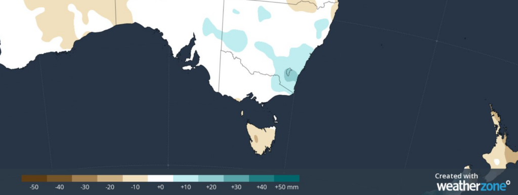
The last three months in Tasmania have also been exceptionally dry at a time of year that’s usually the soggiest. The map below shows the rainfall that fell in the three months up to the end of October 2023.
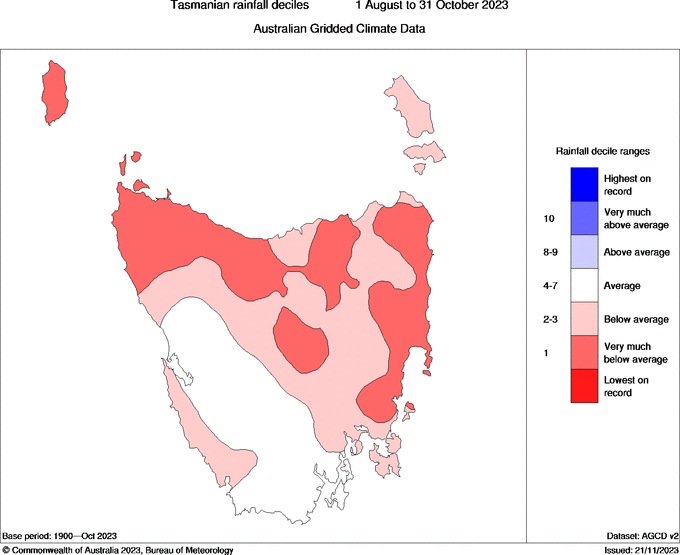
Image: Tasmania rainfall deciles between August 1 and 31 October 2023.
Like most of the Australian mainland, the dry weather in the last three months has been caused by a combination of El Niño and a positive Indian Ocean Dipole (IOD). These drivers reduced the amount of moisture moving over the state from the north and east in particular.
So, will this weather continue?
El Niño should continue throughout summer, bringing average to slightly below average rainfall to Tasmania. However, for western parts of Tasmania there is not a notable increased chance of dry conditions under the influence of El
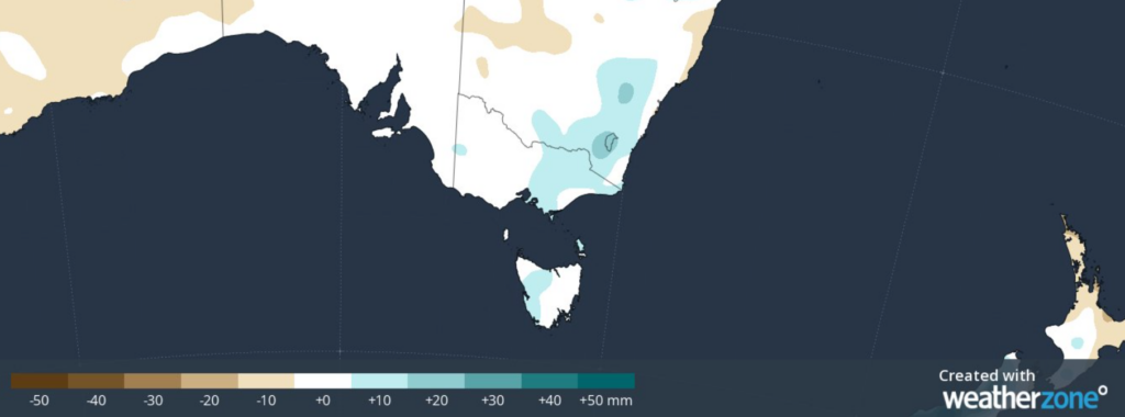
The map below shows the summer mean rainfall deciles for 14 El Niño events since Federation.
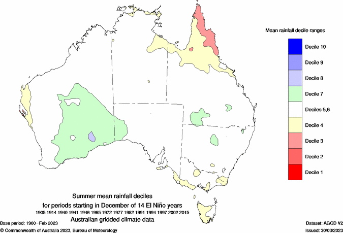
Image: Summer mean rainfall Deciles during 14 El Niño events, Source: BOM
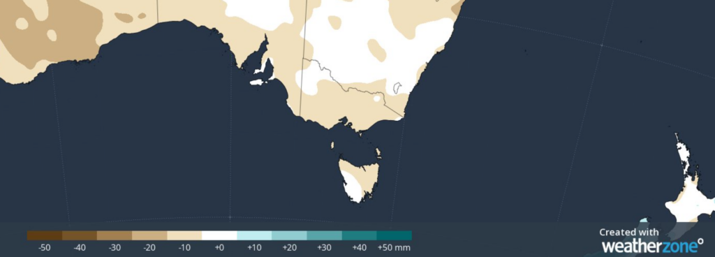
A positive phase of the Indian Ocean Dipole (IOD) is also expected to linger into early summer which brings drier than average conditions to northern and eastern Tas.
During eight positive IOD events in recent history very much drier than average conditions impacted the eastern half of Tasmania.
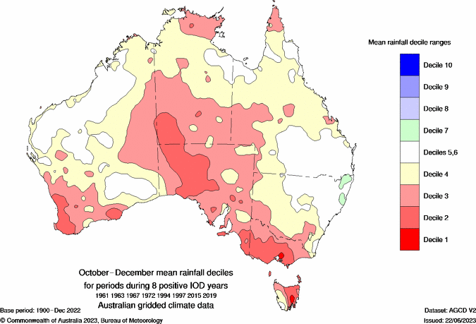
Image: October-December mean rainfall deciles during 8 positive IOD events. Source: BOM
The Southern Annular Mode (SAM) plays a major role in Tasmania’s weather by either shifting the frontal passage north or south.
During El Niño, negative phases of SAM are more likely, which shifts the fronts further north. With cold fronts more frequent it can bring wet conditions to western Tas but dries out conditions in the north and east. The image below shows how negative SAM impacts Australia.
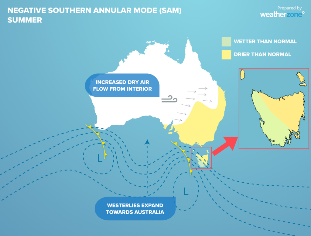
Image: Negative SAM
The maps below show the rainfall forecast for this summer with drier conditions expected under the influence of the positive IOD and El Niño in December.
Despite El Nino at play which typically brings drier conditions to much of Australia, January looks wetter than average for western Tasmania under the influence of negative SAM.
Images: December (top), January (middle) and February (bottom) forecast monthly rainfall anomalies
Temperatures across Tasmania are expected to be slightly above average this summer. Hobart could see a couple of days over 35°C which has not been recorded in the city for two years.
Using Opticast’s nowcasting and forecasting capabilities, you will have long-term outlook covering rainfall and extreme heat events out to 12 months. This can significantly improve your planning as you integrate the data with site-specific hydrological parameters.
With renewables making up more of Australia’s energy mix every year, we want to support your business to make informed critical decisions and improve your overall generation and safety. For more information please contact us at apac.sales@dtn.com.


