While there are many types of thunderstorms, squall-line thunderstorms are one of the largest types and impact the highest number of people when they roll through.
Squall lines are a special and organised version of a traditional thunderstorm. These are almost always associated with a broad scale synoptic feature (like a front or trough) that allows storm cells to help reinforce each other’s updrafts and downdrafts. The cycle works like this:
- A large amount of rain-cooled air from a downburst pushes forward ahead of a thunderstorm, creating a gust front.
- This gust front behaves exactly like a cold front, pushing the air over the top of it as it moves.
- If the air ahead of the gust front is sufficiently hot and unstable, the updraft is strengthened
- The strong updraft displaces more cold air and condenses water high in the clouds, causing it to rain and the air to sink as a downdraft
This self-sustaining structure allows the line of thunderstorms to propagate over large distances and persist for many hours.
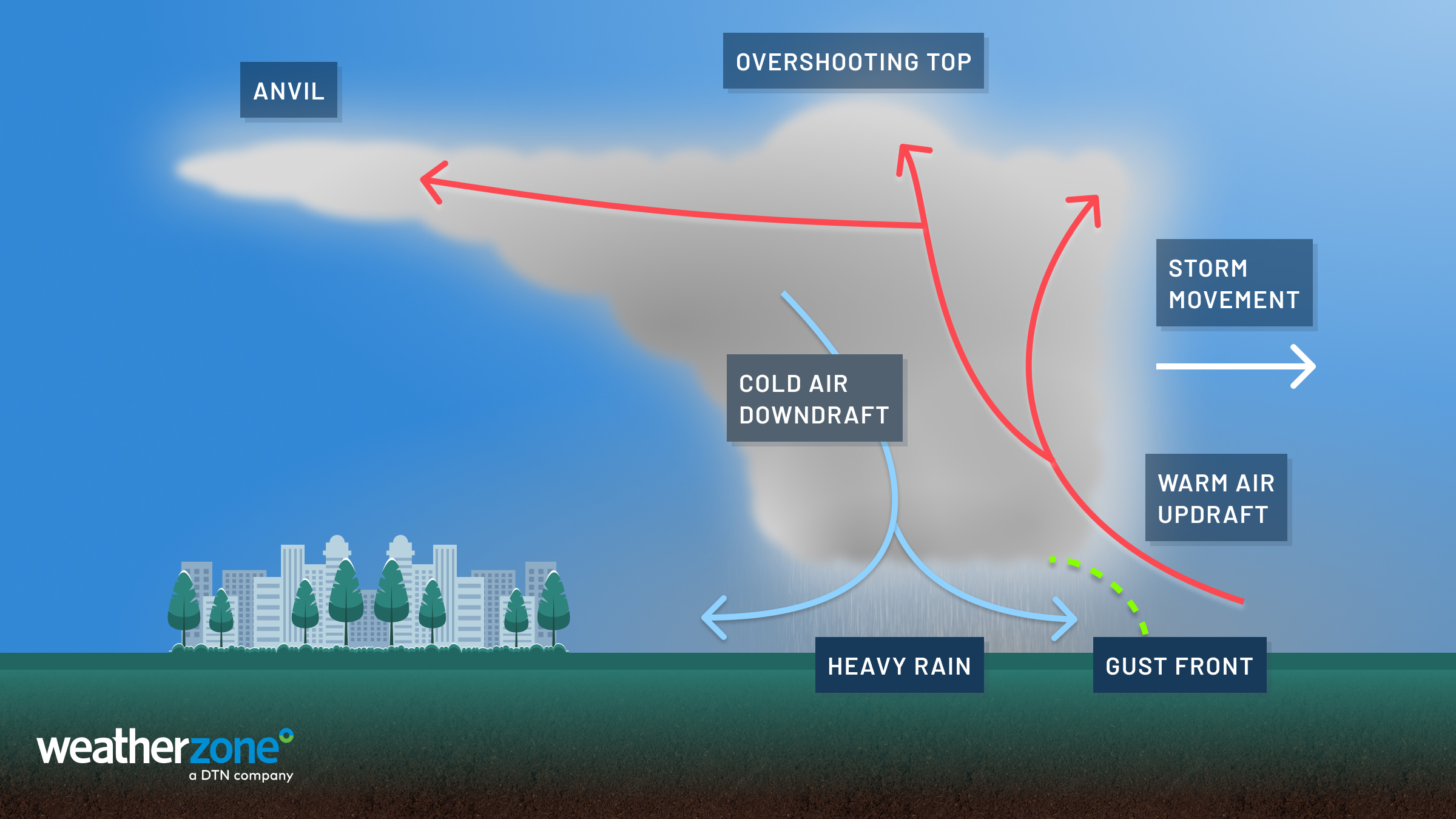
Image: Diagram of a squall line thunderstorm. The cold air downdraft helps to propel the warm air upwards, continually feeding the thunderstorm.
A common trait of squalls is the development of a ‘bow-echo’ in the radar trace. This pattern looks like a backwards ‘c’ shape (if the storm is moving west to east) and indicates that a gust front is pushing through the centre. This is a very strong indicator that a squall has started. As the squall propagates, the gust front spreads along the length of the front, stretching the ‘c’ pattern so it appears almost straight. Hence why they are sometimes called ‘straight-line’ thunderstorms.
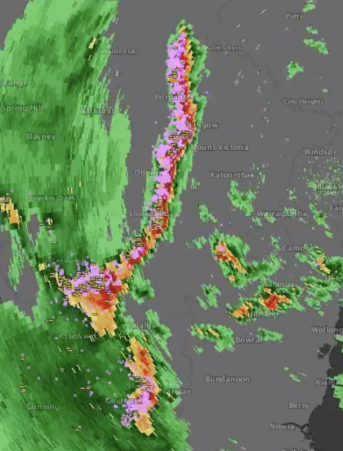
Image: A bow-echo from a squall line over Oberon in 2017
Squalls can often be seen as arcus clouds (like a long tube ahead of a storm) forms, riding the gust front ahead of the squall.
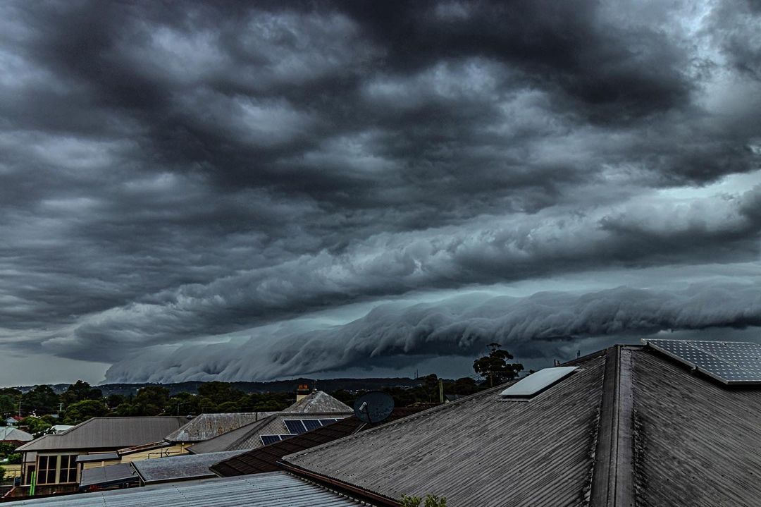
Image: An arcus cloud over Newcastle as a squall-line passed in 2021 Source: @louisefaulknerphotography/Instagram
Squall lines bring a very high chance of damaging wind gusts (exceeding 90km/h) and even destructive wind gusts (exceeding 120km/h) with the strongest squalls along the gust front. This means that a very large area (hundreds to thousands of kilometres) may be exposed to these gale-to-storm-force winds. In the United States, the most powerful squall-lines are called ‘derechos‘ and often cross several and sometimes dozens of states at a time.
Squalls are particularly dangerous over the open ocean, as the gust front can help build and propagate a narrow set of very large waves (often classified as rouge waves with heights more than double that of the significant wave height). These waves can persist for hours after the thunderstorm has dissipated given the right conditions, meaning they can appear out of the blue.
While damaging-destructive wind gusts and powerful seas are common with squall lines, they can also bring brief but intense periods of heavy rain (often more than 1mm per minute), large-to-giant hail, and tornado outbreaks.
Video: A squall-line pushing over the Top End in December 2021
Squall-line thunderstorms are almost always severe, so if you see one or if one is forecast for your area, keep an eye out on the warnings here.
Many industries can be greatly affected by squall line thunderstorms, including energy networks, mining and aviation. DTN APAC forecasts these thunderstorms ahead of time, and our meteorologists can provide special weather briefings if severe weather is expected for your business. To find out more, please email us at apac.sales@dtn.com.


