
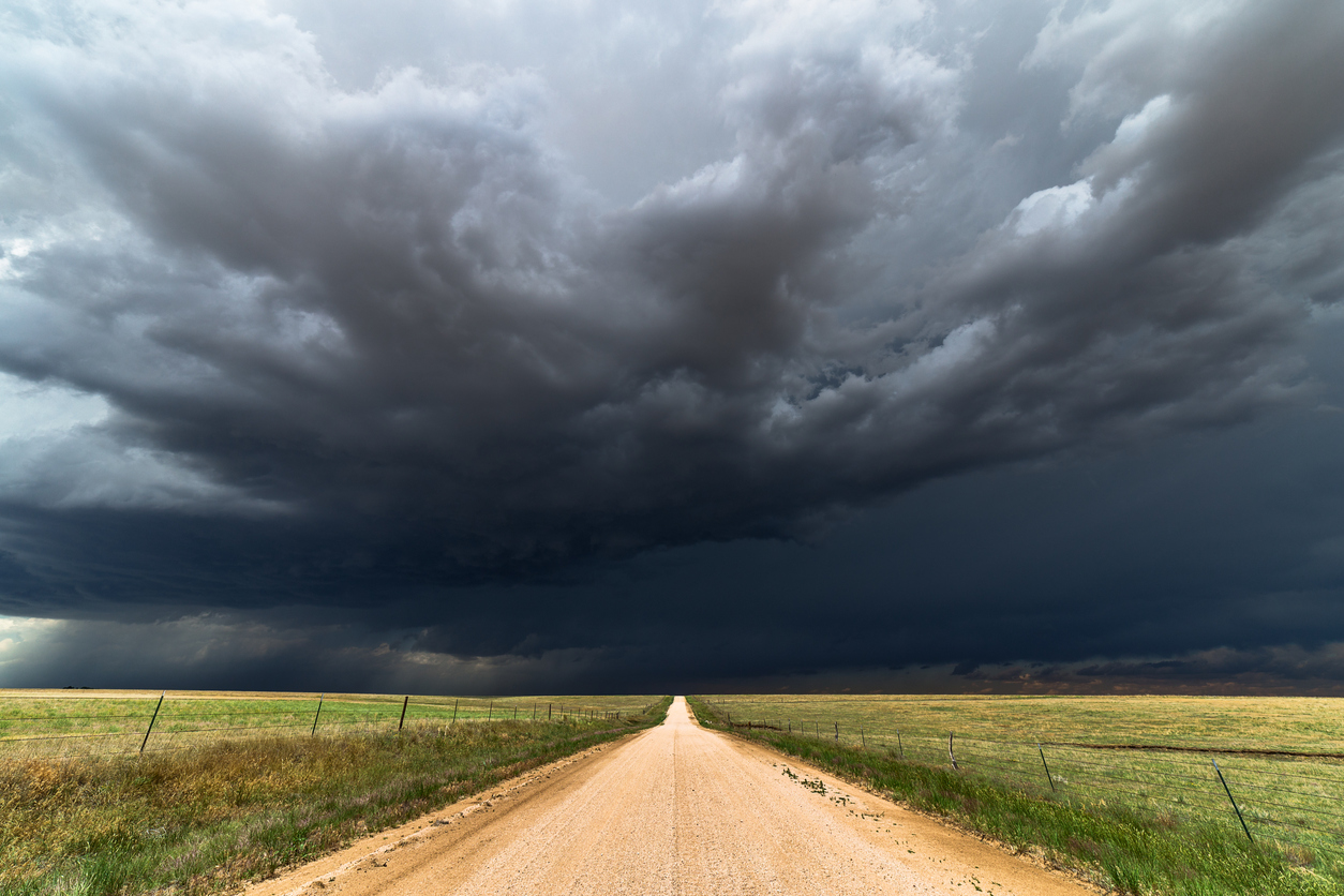
Abnormally warm oceans surrounding Australia and a developing negative Indian Ocean Dipole will increase the likelihood of abnormally wet weather across large parts of the country this spring, along with an increased risk of flooding and severe thunderstorms disrupting businesses and industries.
Spring in Australia runs for three months from the start of September to the end of November. This time of year is characterised by rising temperatures and increasingly active weather, typically featuring vast rain-bearing cloudbands, prolific thunderstorm activity and building tropical moisture in the lead-up to the northern wet season.
Spring weather this year is expected to be influenced by several broad-scale features:
- A negative Indian Ocean Dipole (IOD) is expected to emerge to the northwest of Australia this spring, increasing the amount of moisture-laden air flowing over Australia from the tropical Indian Ocean.
- The Pacific Ocean is expected to stay in a neutral phase this spring (neither La Niña nor El Niño), although a weak La Niña-like pattern may develop.
- Sea surface temperatures in the Australian region are expected to be warmer than average throughout spring. These relatively warm waters will help supply additional atmospheric moisture for rain and clouds over the Australian continent this spring.
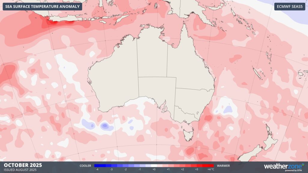
Image: Forecast sea surface temperature anomalies around Australia in October 2025.
Rain and thunderstorms
Both rain and thunderstorm activity are expected to be above average over large areas of Australia this spring, mainly in the eastern two-thirds of the country. This will be due to the combined influence of enhanced moisture in the atmosphere and an increased likelihood of cut-off lows occurring near Australian longitudes.
By contrast, some northern and western parts of Australia are expected to see below average rain this spring. This contrasting rain outlook between the east and the west suggests that the upper-level pressure patters will favour the types of systems that initiate rain and storms over central or southern Australia before moving towards the east.
The maps below shows one model’s prediction for the chance of having a wetter than normal spring in 2025.
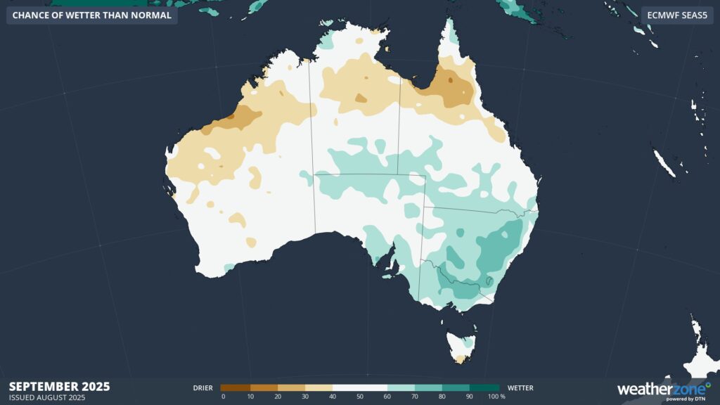
Image: Probability of exceeding median rainfall during September 2025, according to the ECMWF SEAS5 model.
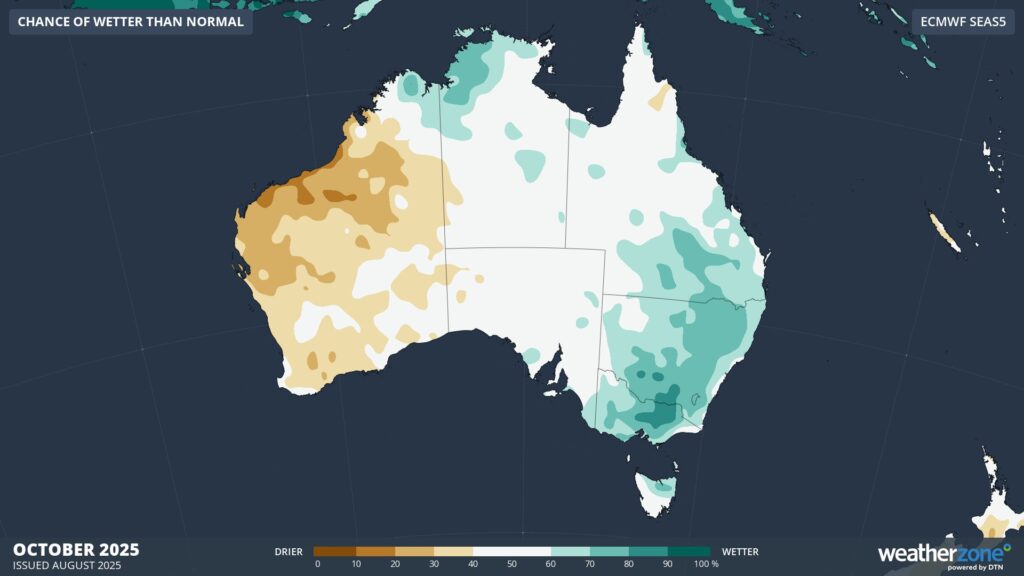
Image: Probability of exceeding median rainfall during October 2025, according to the ECMWF SEAS5 model.
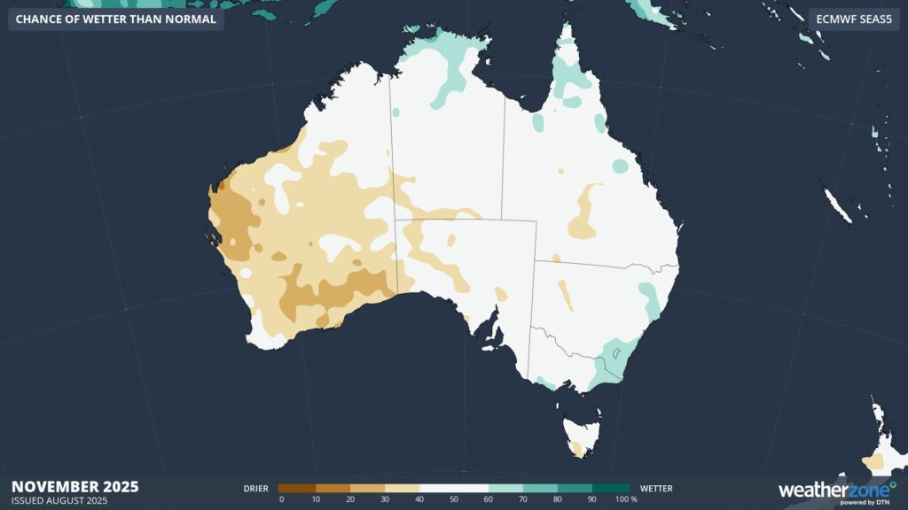
Image: Probability of exceeding median rainfall during November 2025, according to the ECMWF SEAS5 model.
Temperature
Increased cloud cover over Australia this spring is expected to help moderate maximum temperatures, with much of southern and eastern Australia predicted to see cooler-than-average daytime temperatures between September and November.
Note that temperatures will still rise throughout spring and gradually become warmer in the lead-up to summer. However, days should be a bit cooler than you would expect to see in an average spring in some parts of the country.
This spring’s ample cloud cover should also reduce the likelihood of outbreaks of intense early season heat in eastern Australia, while also reducing solar generation capacities.
Some areas of northern and western Australia could buck the trends mentioned above and experience warmer-than-average daytime temperatures this spring. Some forecast models even suggest that mean maximum temperatures will be in the top 20 % of historical records this spring across parts of northern Australia. These abnormally warm temperatures may help enhance bushfire activity in the final months of the dry season.
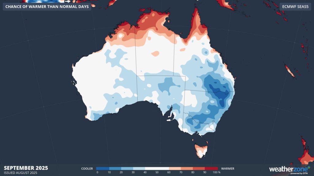
Image: Probability of exceeding median maximum temperature during September 2025, according to the ECMWF SEAS5 model.
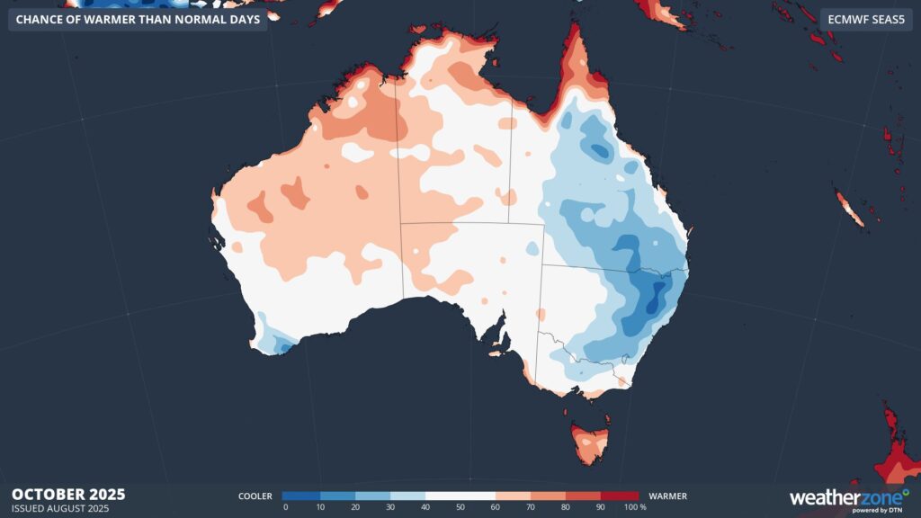
Image: Probability of exceeding median maximum temperature during October 2025, according to the ECMWF SEAS5 model.
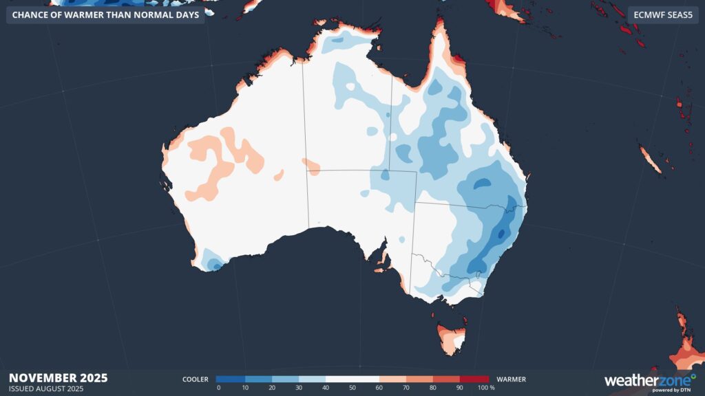
Image: Probability of exceeding median maximum temperature during November 2025, according to the ECMWF SEAS5 model.
This spring is expected to feature a contrasting mix of rain and temperatures across Australia. Spring also marks the beginning of the severe weather season in Australia, which runs from about October to April during the warmer months of the year. This spring could kick the severe weather season off with a bang thanks to increased rainfall and thunderstorms in some parts of the country.
How DTN APAC can help
The shifting climate is bringing increased complexity and greater risks to businesses worldwide. We are here for you, delivering trusted weather solutions to optimize your operations and profitability.
DTN APAC is a diverse team, with global forecasting, product development and analytics expertise. Couple this with extensive industry experience spanning Aviation to Energy, and we are primed to assist you in strengthening your response to weather impact.
We work hard to identify your operational pressures and tailor our services and products to meet your needs. Concise communication, giving you full situational awareness exactly when you need it, is our focus. We want to reduce weather risk in your operations, every day.
We deliver clear and comprehensive weather data that you can’t get anywhere else, personalised risk assessments and briefings to you and your team, so that your critical decisions can be made with confidence.
We are available 365 days a year, so you always have the timely guidance you require, especially when severe conditions hit.
You have our insights to rely on to see you through complex situations, minimising potential loss of profit and maximising the safety of your staff and assets.
Learn more about our large range of industry leading products and services or email us at sales.apac@dtn.com
Thumbnail image source: iStock / mdesigner125




