
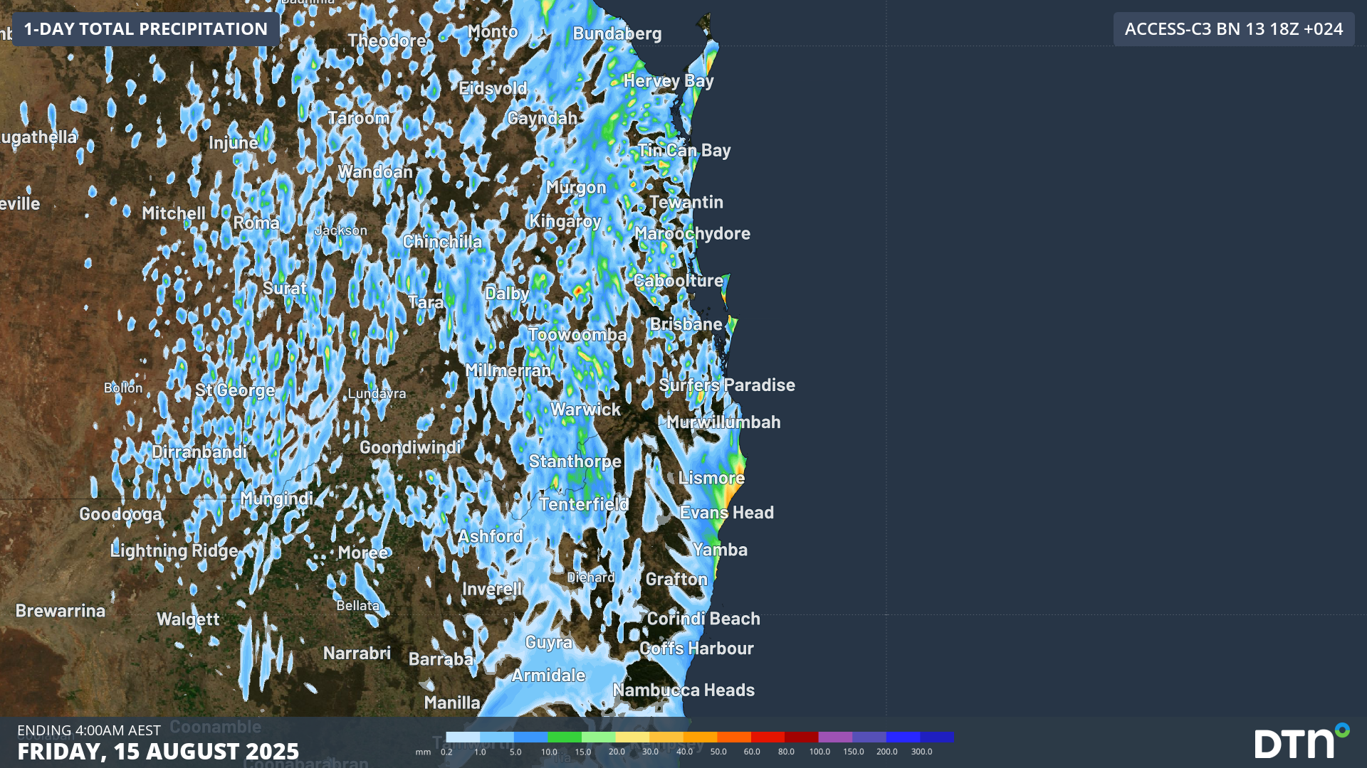
Severe thunderstorms producing heavy rain, large hail and lightning are impacting parts of Queensland and NSW on Thursday.
Winter is a quiet time for thunderstorm activity in eastern Australia because there is less atmospheric instability and surface heating for the storms to develop compared to spring and summer.
However, there are rare cases where all of the ingredients come together to cause severe winter thunderstorms over parts of eastern Australia, and this unusual situation is happening this week.
A pool of cold upper-level air interacting with ample atmospheric moisture is causing thunderstorms to develop over a broad area of southeast Queensland and northeast NSW on Thursday.
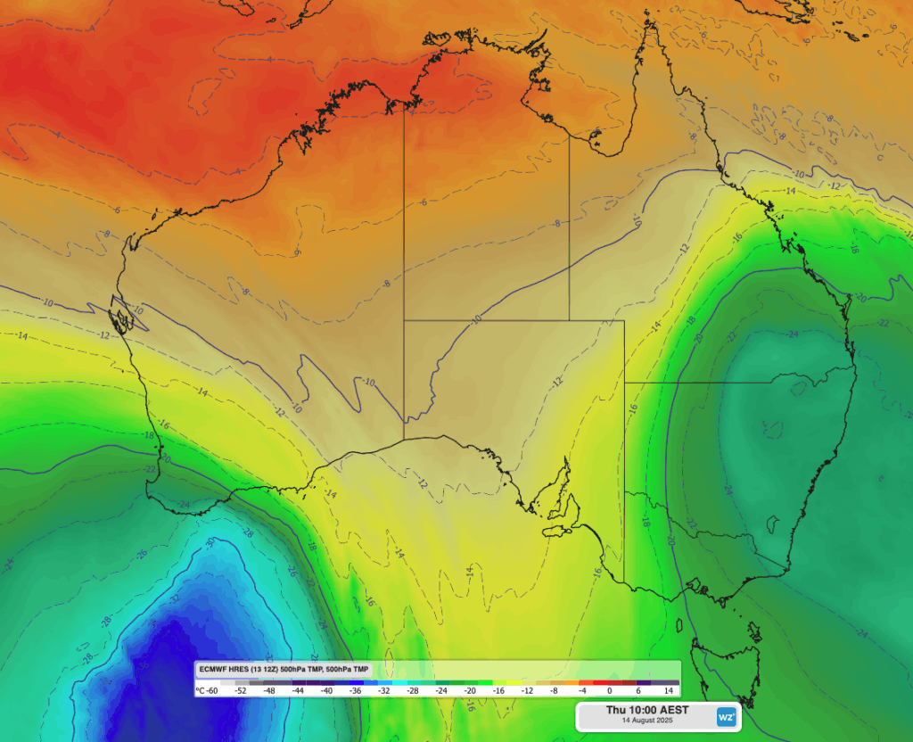
Image: 500hPa temperature at 10am AEST on Thursday, showing a large pool of cold upper-level air over eastern Australia.
This system already triggered a few thunderstorms on Wednesday afternoon, which caused large amounts of small hail in parts of both states, including Grafton and the Glass House Mountains region.
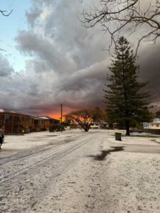
Image: Hail in Grafton, NSW on Wednesday, August 13, 2025. Source: @em.norton / Instagram
Thursday’s thunderstorm activity has been more widespread than Wednesday, with areas experiencing large hail and plentiful accumulations of smaller hail stones. While wintertime thunderstorms are less likely to become severe than their summertime counterparts, it’s not unusual for winter storms to cause lots of small hail that can accumulate on the ground.
Video: DTN’s Stormtracker dashboard showing satellite, radar and the DTN Total Lightning Network overlaid on Thursday, August 14, 2025.
Severe thunderstorm warnings have been issued by the Bureau of Meteorology this afternoon for parts of southeast Queensland. Even thunderstorms outside of these warnings can be dangerous due to their lightning, rain and small hail. Short periods of heavy rain can cause driving conditions to become hazardous and large accumulations of small hail can cause structural damage and affect crops.
How DTN APAC Total Lightning Network can keep you and your staff safe with Lightning Alerting
Our Total Lightning Network is the intelligent lightning solution that goes above and beyond to alert lightning and increase your lead time before the storm hits.

Image: Don’t get caught out by an incoming storm with alerting across your work site. Source: iStock / Jurkos
We utilise a vast global sensor network, created with our partner Earth Networks. Over 1200 sensors in 40+ countries provide a worldwide view of both intra-cloud (IC) and cloud-to-ground (CG) lightning strikes, enabling businesses to plan and respond with the most precise insight available. Our system can detect and calculate strike locations with incredible accuracy, offering real-time lightning mapping for a comprehensive view of storm activity.
Offering unsurpassed accuracy, with real-time sensing to <200m, we integrate with your existing systems to keep your enterprise operating within your defined severe weather thresholds. Our technology also helps monitor radiation from electrical discharges and ensures every lightning flash is accounted for.
The Total Lightning Network can be set up with DTN APAC Onguard Alerting: a scalable visual and audible alarm system that provides simultaneous sitewide alerts to protect your staff and assets when lightning is detected within your thresholds.
Onguard can be customised to your Trigger Action Response Plans (TARPs) and other considerations, ensuring you are securing the safety of your sites based on your existing, functional parameters.
Onguard provides clear, sitewide lightning risk communication for your operations personnel, but also for contractors and visitors who don’t have access to an existing alerting system. The light and sound alerts give everyone on site adequate time to act quickly when thresholds are breached.
With a combination of light beacons and sounders, and a modular, scalable configuration, you can customise the setup to suit any site arrangement and maximise your coverage.
Leave nothing to chance. Be confident working outdoors with the most sophisticated lightning alerting system, delivering intelligence to any device across your business network. Whether you need a personal lightning alerting tool for individual safety or enterprise-wide monitoring, our solution is designed to emit timely alerts and protect your operations.
Learn more about our large range of industry leading products and services or email us at sales.apac@dtn.com




