
Sydney’s days have been so hot this October that the city is currently on track to break the average maximum temperature record for November.
Frequent westerly winds, a lack of cloud and rain, and repetitive bouts of hot air from inland NSW have caused Sydney’s daytime temperatures to run about 5°C above average so far this month.
Including recent maximum temperatures of 36.0°C on Monday and 37.0°C on Wednesday this week, the running average for Sydney’s first 22 days of October is 27.9°C.
Using DTN APAC’s 14-day energy forecast, as seen below, the average maximum temperature for October in Sydney should come in at just around 27.1°C. This would be roughly 5°C above average for this time of year.
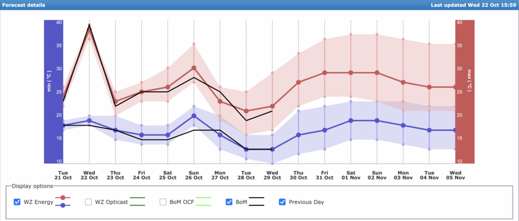
Image: DTN APAC’s 14-day temperature forecast for Sydney.
If this happens, it will not only beat the previous October record of 26.2°C from October 1988, but it will also trump the November record of 27.0°C from 2019. No spring month has ever been this hot in Sydney’s meteorological history, which dates back to 1859.
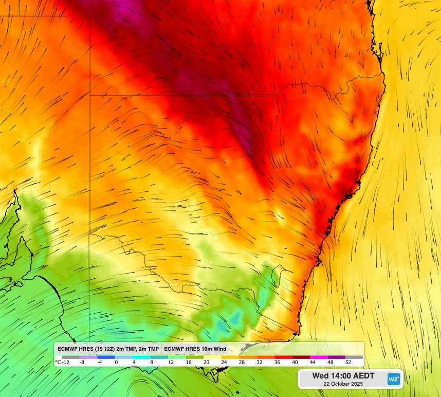
Image: Forecast air temperature and wind at 2pm AEDT on Wednesday, October 22, 2025, showing warm northwesterly winds flowing towards Sydney.
Why is Sydney so hot and dry this month?
In a typical October, Sydney would experience periods of warm and dry weather interspersed with bursts of mild and stormy weather. This month, however, the dry and hot days have been plentiful, while cooler and wetter days have been scarce.
One of the main reasons for Sydney’s extremely warm weather this month has been the ongoing influence of a negative Southern Annular Mode (SAM) in the Southern Hemisphere.
A negative SAM occurs when the belt of westerly winds that flows around Antarctica becomes displaced to the north. Because this westerly wind belt passes between Australia and Antarctica, a negative SAM during spring typically causes westerly winds to become more prominent over southern and eastern Australia. For eastern NSW, a negative SAM in spring promotes hot and dry westerlies.
The SAM has been in a negative phase for most of September and October in response to a sudden stratospheric warming (SSW) event that occurred high above Antarctica over the past several weeks.
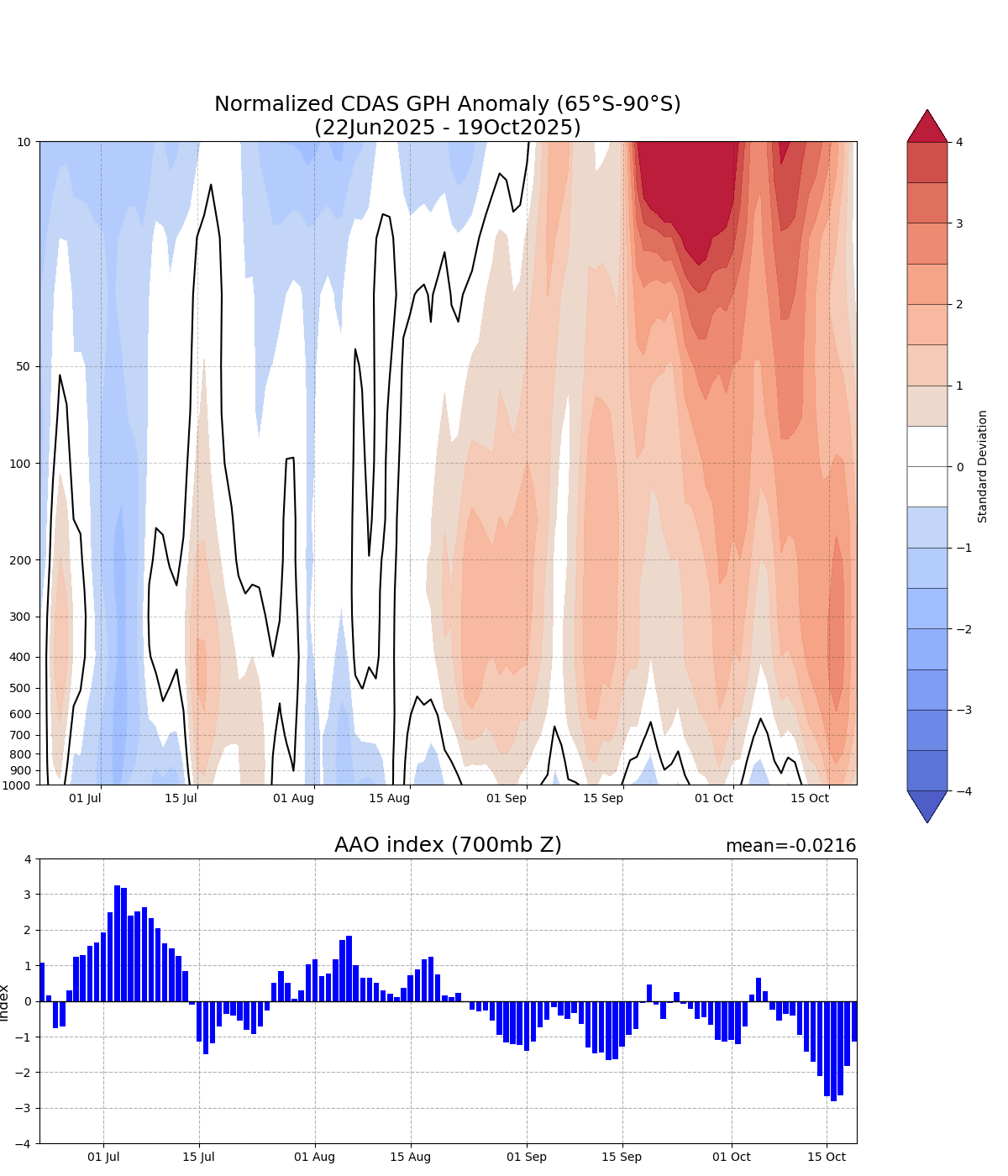
Image: Geopotential height anomalies for the polar region south of 65°S over the past four months. The red shading on the top graph shows a period of sudden stratospheric warming (SSW) in September and October. The blue bar graph at the bottom shows that this SSW has been associated with a predominantly negative southern annular mode (SAM) this spring. Source: NOAA
This month’s prolonged and strong negative SAM is likely a big reason for Sydney’s relentless run of warm and dry days.
Climate change is also likely playing a part, with Sydney’s springtime maximum temperatures having increased by close to 0.7°C since 1910.
DTN APAC has grown to become the outright leader within the Australian energy market, serving wind, solar, hydro, trading, utilities and network companies.
You can’t control the weather, but you can gain precision insights to optimise your response. What lights us up is providing your energy business with tailored weather information to reduce your risk and keep you moving ahead of the curve.
Our services cover all aspects – from wind and solar generation to demand forecasts, wholesale markets to retail so, no matter where your company sits, we have solutions for you. We have worked closely with market participants to create products that meet the evolving needs of the sector, aiming to increase safety and profitability for our customers.
Your customisable Energyzone interface can assess heat/heatwave potential from 14 days out to 12 months. It allows you to benefit from specialised indices for CDD/HDD/apparent temperature/sunshine hours to help accurately predict the demand for electricity. This, along with high-resolution modelling and local knowledge, gives you the most precise information available to make the critical decisions that bolster your production.
Benefit from the timely delivery of accurate weather information, allowing informed and effective decision-making.
How DTN APAC Risk Communicator can inform your decision making with tailored weather and seasonal climate outlook
DTN APAC is a diverse team, with global forecasting, product development and analytics expertise. Couple this with extensive industry experience spanning Aviation to Energy, and we are primed to assist you in strengthening your response to weather impact.
We work hard to identify your operational pressures and tailor our services and products to meet your needs. Concise communication, giving you full situational awareness exactly when you need it, is our focus. We want to reduce weather risk in your operations, every day.
We deliver clear and comprehensive weather data that you can’t get anywhere else, personalised risk assessments and briefings to you and your team, so that your critical decisions can be made with confidence.

We are available 365 days a year, so you always have the timely guidance you require, especially when extreme temperatures hit.
Learn more about our large range of industry leading products and services or email us at sales.apac@dtn.com
Thumbnail image source: iStock / Brian Bornstein


