Prosper in a dynamic world
Search

A week over 30 degrees on the cards for Adelaide


A weeklong run of heat is on the horizon for Adelaide, with daily maximum temperatures expected to remain in the 30’s for at least seven days from this Friday. 

This will be the first time Adelaide has seen a run of seven days over 30C since January 2023, when the city saw 8 days above 30°C. 

A ‘train’ of high-pressure systems in the Bight and Tasman Sea are expected to force cold fronts and their associated cooler airmasses south during the next 5-7 days.  

This is in response to a strong sub-tropical ridge over Australian longitudes, which is commonly associated with prolonged heat. 

The image below shows the low-pressure systems ‘hugging’ Antarctica, as the Sub-tropical Ridge squeezes them south. 

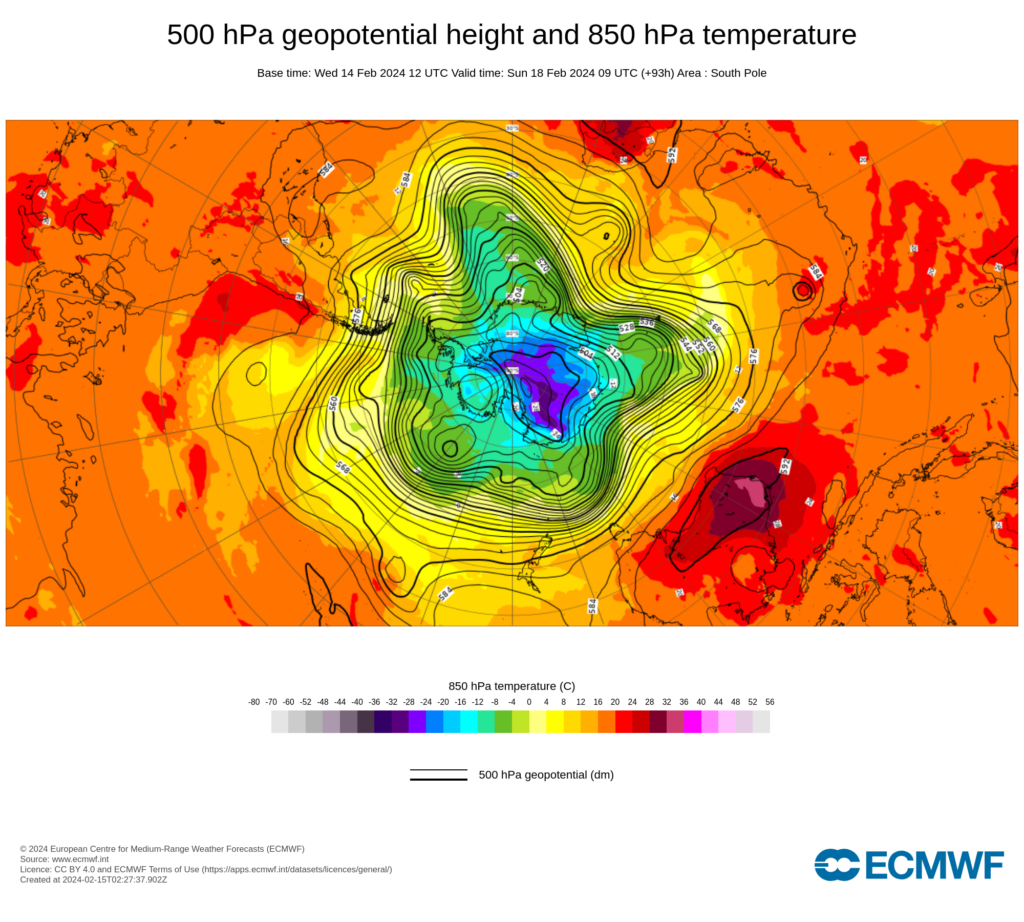
Image: ECWMF 500 hPa geopotential height 850 hPa temperature 

This pattern will cause heat to linger across parts of SA, Vic and western NSW from late this week well into next. 

The map below shows a low intensity heatwave forecast for much of SA for three days from Sunday, while severe heatwave conditions are impacting western SA and much of WA. 

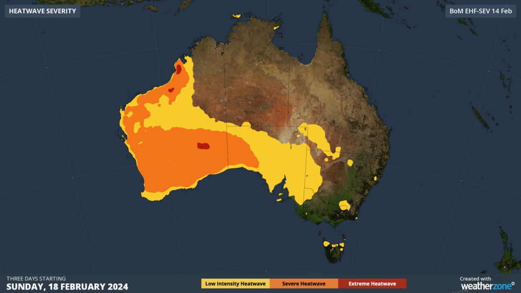
Image: Heatwave severity forecast for three days starting Sunday, February 18. 

The heat is expected to peak on Sunday and Monday and potentially later in the working week in Adelaide, with temperatures reaching the mid to high 30’s 

The map below shows the maximum temperatures are forecast to reach the high 20’s to low 40’s across much of SA on Sunday.  

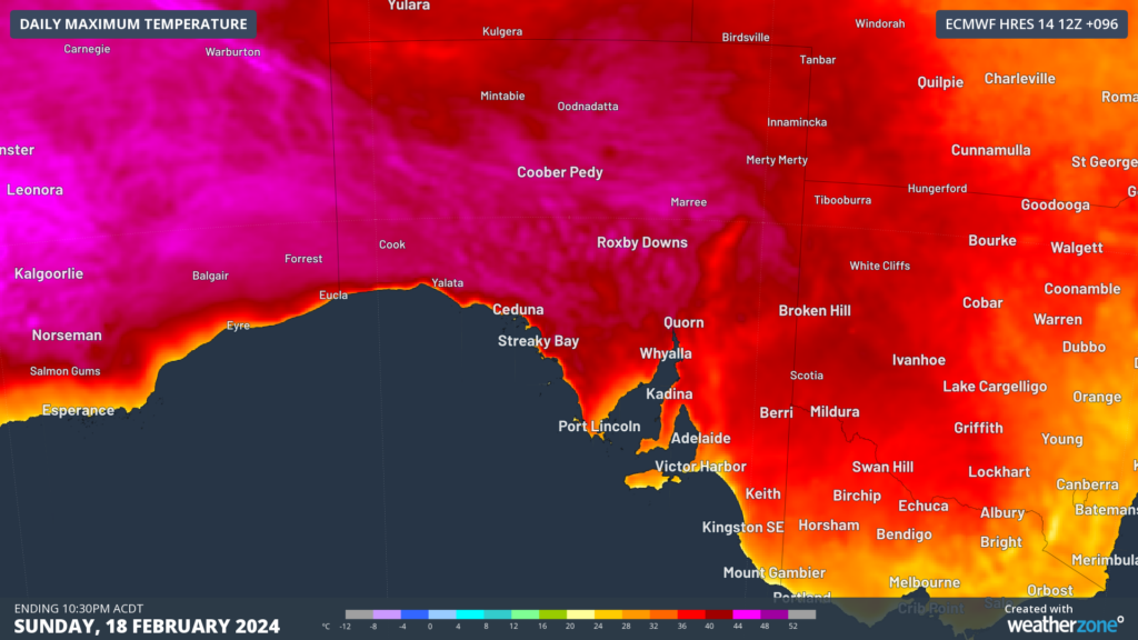
Image: Maximum temperature forecast for Sunday, February 18, according to ECMWF. 

A cold front is expected to sweep across southeastern Aus next Thursday, February 22, which could bring a cooler airmass into Adelaide.  

Ahead of this cold front, the southeast could see strong, dry and hot northerly winds which could bring severe fire danger to the region. 

At this stage it is uncertain how far north this cool airmass will move. If it slips to the south, it looks like Adelaide could remain hot until the weekend beginning Saturday, February 24.  

For more information on our energy forecasts, please contact us at apac.sales@dtn.com

Latest news

Satisfy your weather obsession with these news headlines from around the nation, and the world.

How does DTN help businesses monitor bushfire induced pyrocumulonimbus thunderstorms that ignite more fires?

Intense heat from bushfires during elevated fire danger days can trigger fire-induced pyrocumulonimbus thunderstorms that ignite additional fires. In early January 2026, an extreme heatwave sweeping over southeastern Australia brought catastrophic fire danger to Victoria. Intensely hot bush and grass fires spread erratically and quickly in hot, dry and gusty winds, with pyrocumulonimbus generating lightning, […]

Active seas to the north and east of Australia disrupting port and maritime operations

Seas to the north and east of Australia are experiencing periods of increased activity this week, leading to disruptions to port, maritime and offshore operations. Intense and hazardous Tasman Sea Ocean conditions across NSW’s South Coast rapidly deteriorated last Friday as a deep feed of easterly winds whipped up large and dangerous seas. The Batemans […]

Transport, emergency and energy industries flooded across Greater Sydney with weekend deluges

Transport, emergency, energy and port industries in eastern NSW and Sydney were impacted by significant flash flooding with intense and heavy rainfall this weekend. Rainfall rates between 80 and 140mm in one to three hours were registered across parts of Sydney’s Northern Beaches and Central Coast on Saturday afternoon and evening. In some areas, these […]

DTN Dangerous Thunderstorm Alerts in action with severe thunderstorms disrupting Perth industries

Severe thunderstorms impacted southwest WA and the Perth region on Sunday, December 14, 2025, triggering Dangerous Thunderstorm Alerts (DTA) by DTN for industries and businesses in the region. DTN operates Dangerous Thunderstorm Alerts (DTA) which alert businesses and industries to thunderstorms based on intensity and movement. These alerts provide advanced notice of thunderstorms moving into […]