Signals of a negative Indian Ocean Dipole (IOD) developing in the coming months could bring increased risk of heavy rainfall, severe thunderstorms and tropical cyclones for the mining sector.
Indian Ocean Dipole (IOD)
The IOD is a measure of the difference in sea surface temperatures across the equatorial Indian Ocean.
A negative IOD occurs when cooler-than-average water sits on the western side of the Indian Ocean, near the Horn of Africa, and warmer-than-average water lies on the eastern side of the Indian Ocean, near Indonesia. A positive IOD is the opposite of this pattern (cooler water in the east, warmer in the west).
Each phase of the IOD also influences atmospheric conditions above the Indian Ocean and surrounding countries. For Australia and Indonesia, a negative IOD typically increases the likelihood of above average rain over large areas, while also promoting cooler days in Australia’s south and east with increased cloud cover.
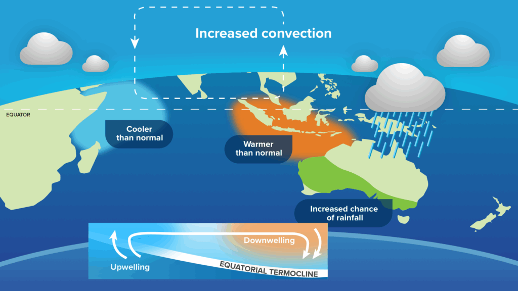
Image: typical oceanic and atmospheric patterns during a negative IOD.
IOD events typically occur between May and November and break down when the Australian monsoon arrives in late spring or early summer.
The IOD dips into negative values
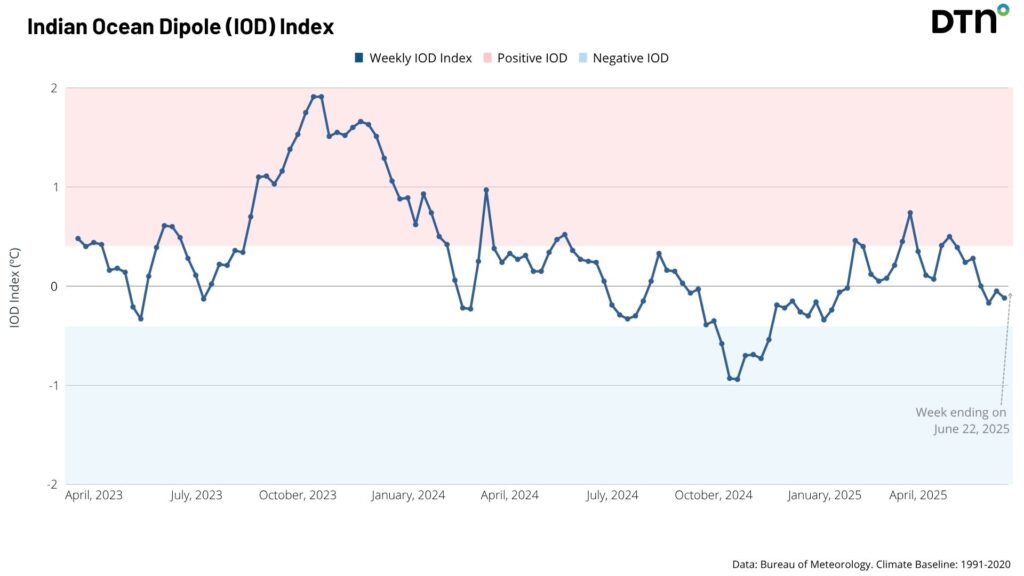
Image: IOD index over the past 26 months since April 2023.
The IOD index dropped below zero in the first week of June. This is the first time values have gone negative since January 2025. The drop comes following cooling over the western Indian Ocean, near the Horn of Africa, and Arabian Sea, with the strengthening of the Indian Southwest Monsoon.
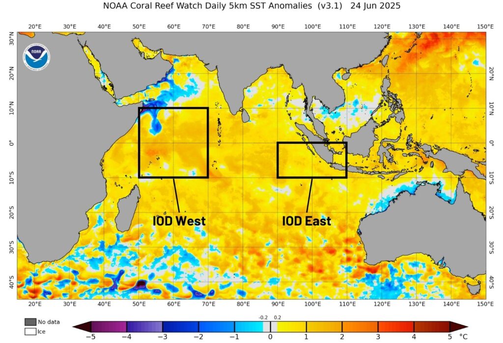
Image: Sea surface temperature anomalies across the Indian Ocean and the IOD monitoring regions on June 24, 2025. Source: NOAA
Last year briefly saw negative IOD conditions during October and November, however this was too short-lived to be considered a negative IOD event.
Sea Surface Temperature (SST) anomalies are expected to warm further in and around the IOD East region, near Indonesia, in the coming months.
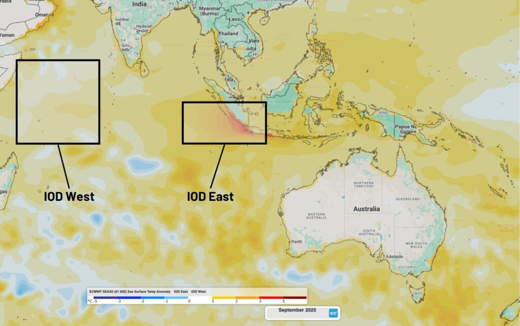
Image: Forecast SST anomalies across the Indian Ocean for September 2025.
This should help tip the IOD index further into the negative values, especially around August and September.
How could a negative IOD impact mining across Australia and Indonesia?
This forecast IOD event could be later than usual, with most IOD events typically occurring between May and November, before breaking down when the monsoon moves over Indonesia in late spring or early summer.
With increased moisture from the warm SST to the northwest of Australia, near Indonesia, a negative IOD brings increased risk of above average rainfall to much of Australia’s north, interior and southeast. This usually occurs through the formation of northwest cloudbands, sending moisture across the continent.
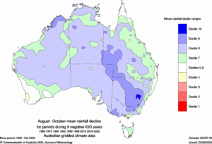
Image: Typical changes to rainfall when a negative IOD occurs between August and October. Source: Bureau of Meteorology
The added cloud cover can also lead to cooler days (and milder nights) over southern and eastern Australia during a negative IOD event.
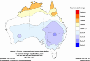
Image: Typical changes to maximum temperature when a negative IOD occurs between August and October. Source: Bureau of Meteorology
The localised very warm waters near Indonesia will promote increased potential for heavy rainfall, flooding and landslides. As a result, the wet season could get started early for parts of Sumatra, Java and Kalimantan.
Video: Forecast rainfall anomalies for each month between July and November 2025.
The nearby warm SST could also promote above average rainfall, thunderstorms and tropical cyclones for northern Australia during late spring and the summer months, even if the potential negative IOD ends before then.
There are several indicators suggesting that we could see this negative IOD event developing later this winter; however, models remain at about a 50% chance of the IOD either remaining neutral or turning negative.
How DTN APAC can help
The shifting climate is bringing increased complexity and greater risks to businesses worldwide. We are here for you, delivering trusted weather solutions to optimize your operations and profitability.
DTN APAC is a diverse team, with global forecasting, product development and analytics expertise. Couple this with extensive industry experience spanning Aviation to Energy, and we are primed to assist you in strengthening your response to weather impact.
We work hard to identify your operational pressures and tailor our services and products to meet your needs. Concise communication, giving you full situational awareness exactly when you need it, is our focus. We want to reduce weather risk in your operations, every day.
We deliver clear and comprehensive weather data that you can’t get anywhere else, personalised risk assessments and briefings to you and your team, so that your critical decisions can be made with confidence.
We are available 365 days a year, so you always have the timely guidance you require, especially when severe conditions hit.
You have our insights to rely on to see you through complex situations, minimising potential loss of profit and maximising the safety of your staff and assets.
Learn more about our large range of industry leading products and services or email us at sales.apac@dtn.com
Thumbnail image source: iStock / Funky-data