
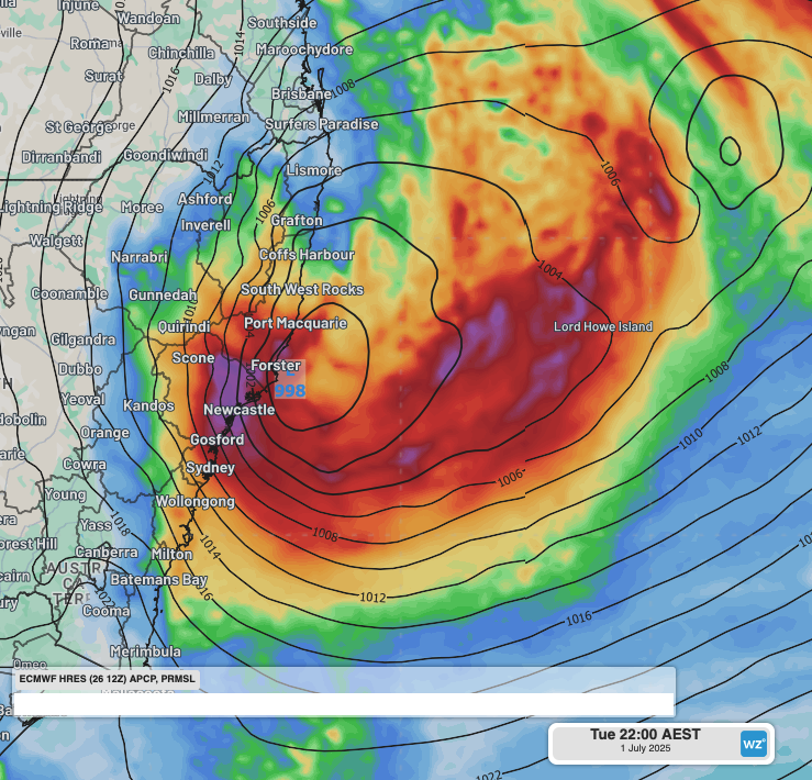
Heavy rain, intense winds and large surf could impact eastern NSW next week as a significant low pressure system develops off the coast, with potential for an East Coast Low.
East Coast Lows (ECL) are a type of low pressure systems that rapidly form and stay within close proximity to the east coast of Australia for at least 24 hours. ECLs produce damaging-to-destructive winds, heavy and intense rainfall, flooding, and/or powerful and erosive surf.
Past major ECLs include the June 2016 storm that eroded Collaroy Beach, the Pasha Bulker storm in June 2007 and the Sygna storm in May 1974. The last ECL to impact Australia was in July 2022.
Where will be most impacted?
A coastal trough will deepen off the northern NSW coast next Monday, June 30. Showers and fresh winds could intensify into heavy and potentially flooding rainfall, and damaging winds as the system develops into a potential ECL somewhere near the NSW coastline on Tuesday, July 1.
Video: 6-hourly rainfall and Mean Sea Level Pressure (MSLP) between Monday, June 30, and Saturday, July 5, according to the ECMWF model.
All models have a significant low developing off the NSW coast from the coastal trough on Tuesday, July 1, but as seen in the image below, uncertainty regarding the proximity and intensity remains elevated.
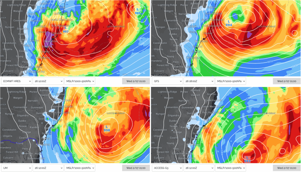
Image: MSLP and 24-hour rainfall accumulation at 1am on Wednesday, July 2, 2025, according to ECMWF (top left), GFS (top right), UKMO (bottom left) and ACCESS-G (bottom right).
The European ECMWF model (top left) shows a strong ECL impacting the NSW coast south of Port Macquarie. The US GFS model (top right) has the low further offshore, with intense rainfall still affecting parts of the Mid North Coast and Hunter. The Australia ACCESS-G and the UKMO UM models (bottom left and right) favour the formation of a Tasman Low well off the coast, rather than a ECL within proximity of coastal NSW.
Rainfall accumulations of 100-200mm are possible over a period of 36-48 hours to Thursday next week, across parts of the Mid North Coast and Hunter, possibly extending as far south as the South Coast. The deep feed of moisture coming off the Tasman Sea could interact with local topography around the Mid North Coast, Hunter and Central Coast, with rainfall totals reaching 300mm possible in some parts.
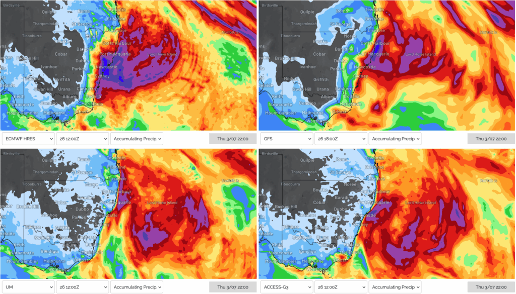
Image: Rainfall accumulations across NSW to 10pm on Thursday, July 3, 2025, according to ECMWF (top left), GFS (top right), UKMO (bottom left) and ACCESS-G (bottom right).
Winds will strengthen over the southern flank of the system on Tuesday, with the strongest winds most likely between Forster and Jervis Bay. Winds will reach peak strength later on Tuesday and across most of Wednesday as the system intensifies rapidly. Wind gusts exceeding 100km/h are possible across coastal NSW, most likely between Coffs Harbour and Jervis Bay, and possibly extending into early Thursday before the system moves further east.
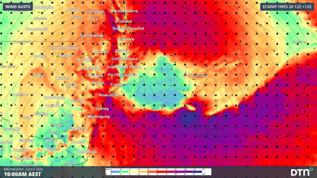
Image: 10 metre wind gusts at 10am on Wednesday, July 2, 2025, according to ECMWF.
The strong winds wrapping into the low pressure system will generate very large waves across the Tasman Sea. Significant wave heights of 5 to 6 metres are expected over coastal parts of the Sydney, Central Coast, Hunter and Mid North Coast regions between late Tuesday and Thursday. Maximum wave heights reaching 11 to 13 metres are also possible.
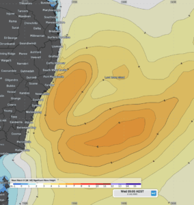
Image: Significant wave height forecast at 9am on Wednesday, July 2, 2025.
Most of the wave energy is expected from the east to southeast direction. Large waves from the east have a much greater potential to cause significant coastal erosion, especially across known erosion hotspots like Collaroy Beach on Sydney’s Northern Beaches, and Wamberal Beach on the Central Coast. Fortunately, the high tides next week will only be moderate in height with the neap tide occurring later in the week.
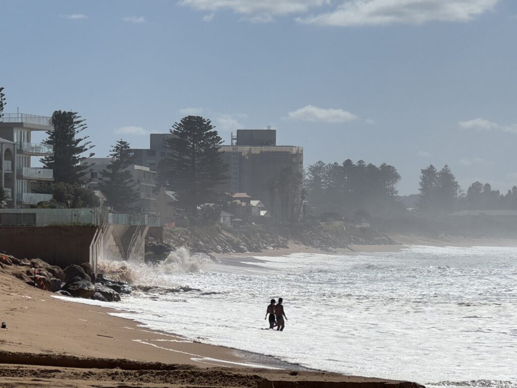
Image: Subsequent Tasman Lows have left erosion prone beaches, like Narrabeen-Collaroy Beach, in a vulnerable state ahead of next week’s swell. Source: Felix Levesque
What makes an East Coast Low (ECL)?
Some of the key ingredients for potential ECL intensification include:
1. Warm Sea Surface Temperatures (SST): A warm Tasman Sea provides the developing ECL with moisture and rising air. The images below show a warm tongue of 22-23°C waters (left image) extending down the Northern Rivers, Mid North Coast and Hunter coastlines with the East Australia Current (EAC). These waters are 2-2.5°C warmer than average for this time of year (right image).
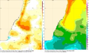
Images: SST (left) and SST anomalies (right) off the NSW coast on June 26, 2025. Source: BoM
2. Baroclinic instability: Air usually grades from warm to cold towards the poles. When surges of cold air move equatorward, like the cold air (blue) seen over inland NSW in the image below, baroclinic instability increases. This causes air to rise along the boundary of the two airmasses and winds start to rotate. This “spins up” the low pressure system faster, leading to rapid intensification.
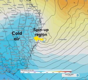
Image: 1000-500 hPa thickness and Mean Sea Level Pressure at 7am on Tuesday, July 1, 2025.
Video: 1000-500 hPa thickness and Mean Sea Level Pressure from 10am on Monday, June 30, 2025 to 4pm on Friday, July 4, 2025, showing the rapid intensification of the low near the NSW coast.
3. A blocking high pressure system: Having a broad and strong high over the Tasman Sea keeps the low pressure system close to the coast, prolonging and increasing the adverse weather. At this stage, high pressure is expected in the lower Tasman Sea, but some models have a weaker high, causing the low to develop further away from the coast and slipping east sooner, limiting its impacts over coastal NSW. Lows that form further offshore are called Tasman Lows.
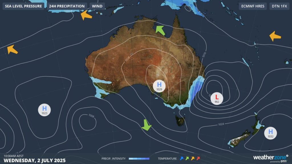
Image: Synoptic chart on the Weatherzone website for Wednesday, July 2, 2025, showing the deep low in the Tasman Sea, with a blocking high extending over New Zealand.
4. An upper trough over the Great Dividing Range: This helps rising air move from the surface low into the upper troposphere, where it’s transported over the surface high pressure and brought back down towards the surface. This process lowers the surface low pressure, and increases the pressure of the high. Intensification of both the surface low and high causes winds driven by the pressure difference to intensify as well.
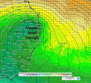
Image: Upper level trough located over the Great Dividing Range on Tuesday, July 1, according to ECMWF.
As seen above, the atmosphere and ocean conditions are primed for the formation of a significant low pressure system in the Tasman Sea. Uncertainty mostly remains as to how close to the coast this low may form, which will be the defining factor on whether we see our first East Coast Low of the season, or another of the numerous Tasman Lows already seen since March.
How DTN APAC can support your business through severe weather
From Ports to Offshore energy farms, our weather solutions can help your business across Australia and Asia Pacific plan ahead and make confidence decisions.
Weatherguard
Whether out in the field, on-site or nationwide, your staff have access, via their device, to real-time alerting and local weather data to support their efficiency and safety during severe weather events.
Whatever the size of your enterprise, farm, business or company, when it comes to severe weather, it’s important that everyone is immediately aware of their personal situation and risk.

Weatherguard gives you and your staff a visual understanding of incoming weather systems, with GIS mapping and radar. Personal push notifications give users real-time severe weather and lightning alerts, based on their phone’s GPS position. Real-time alerting works to keep staff safe and enables operational decisions to be made quickly.
Field and site crews can see the full picture and understand the spread and magnitude of risk to people and assets, providing enhanced synergy between crews and the control room.
Weatherguard delivers complete situational awareness, enhancing critical decision making. Reduce health, safety and environmental impacts associated with weather threat, and improve efficiency across your operations.
DTN APAC Risk Communicators
Our Risk Communicators work closely with you to analyse how weather impacts your operations and communicate potential risks. We can then support your risk management planning, and provide situational awareness and post-event reporting when extreme weather events hit hard.
DTN APAC, is a diverse team, with global forecasting, product development and analytics expertise. Couple this with extensive industry experience spanning Aviation to Energy, and we are primed to assist you in strengthening your operational strategies when responding to weather disruption.
We consult with you to understand the nuances of your operations and your existing procedures and policies. We can then assist in creating communication structures, safety strategies and procedures to mitigate the risks that may impact your workforce, assets and uptime.
Our Risk Communicators are working closely with industries and businesses likely to be affected by next week’s severe weather, in order to mitigate the risk of damaging and long lasting impacts. Our weather risk communicators deliver short- to long- term guidance from:
- hourly-event weather monitoring (assisting you when severe weather is about to hits and is likely to clear).
- week to month operational planning based on likely timing of increased rain or low pressure development.
- seasonal long term planning based on climate drivers and the likely trends across the coming months.
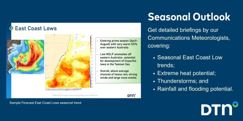
As seen below, long range forecasts provided by our weather risk communicators at the start of autumn signalled for increased activity in the Tasman Sea over the coming autumn and winter.
We deliver clear and comprehensive weather data that you can’t get anywhere else, personalised risk assessments and briefings to you and your team, so that your critical decisions can be made with confidence.
We are available 365 days a year, so you always have the timely guidance you require, especially when severe conditions hit.
You have our insights to rely on to see you through complex situations, minimising potential loss of profit and maximising the safety of your staff and assets.
Learn more about our large range of industry leading products and services or email us at sales.apac@dtn.com




