
A cold front sweeping over southeastern Australia is bringing an icy polar blast and chilly nights.
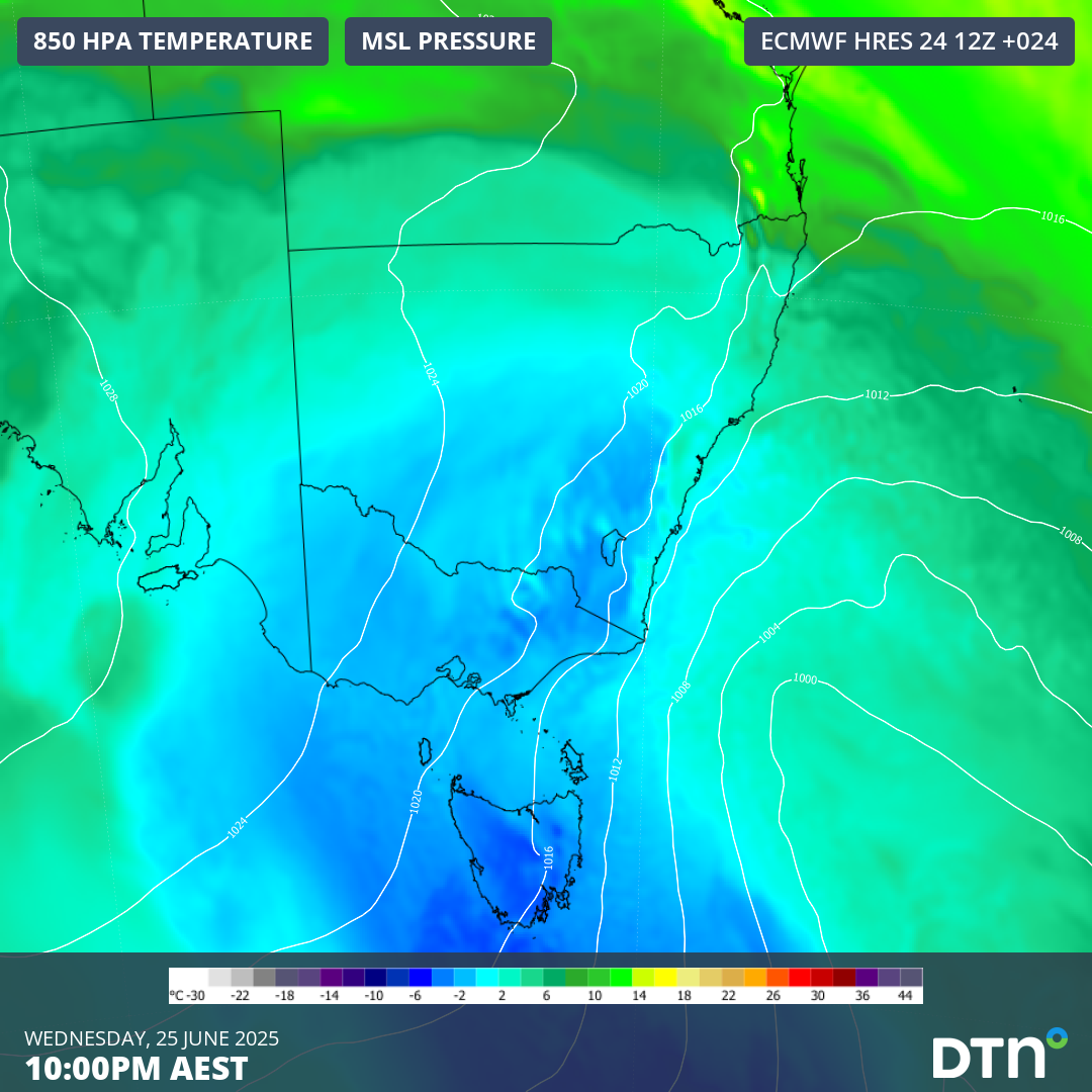
The animation below shows the forecast temperatures at 850 hPa (approximately 1,500 metres up) easily dropping between –2°C to -4°C above the capital cities, which translates to near sea-level surface temperatures in the low-teens.
Video: Forecast 850 hPa temperatures over southeastern Australia between 10pm June 23 and 10pm June 26, 2025.
Strong west-to-southwest winds brought by a powerful cold front, along with cooling showers, will emphasise the cold and make it feel between 3 to 7 degrees colder than actual. The coldest day of the spell is expected today for Victoria and southern NSW, and tomorrow for eastern parts of the country.
Chilly mornings will take hold into the weekend as this polar airmass slowly dissipates and high pressure brings clear skies.
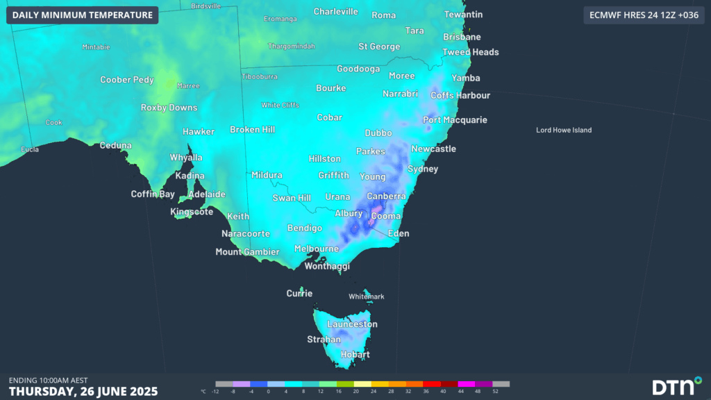
Image: Forecast minimum temperatures across southeastern Australia on Thursday, June 26, 2025.
With all this in mind, here’s the forecast for southeastern Australia’s capital cities:
11°C on Wednesday but feeling no warmer than about 6-7°C with gusty winds and showers. As daytime temperatures gradually warm from Thursday, overnight temperatures are expected to drop between 4 and 6°C for a more extensive period, possibly until Wednesday or Thursday next week.
Tuesday’s maximum of only 13.6°C was the coldest day of the week, with forecasts of 15°C for Wednesday and Thursday expected. The wind chill will however make it feel no warmer than about 12-13°C, with a few showers lingering into the early afternoon on Wednesday. Colder mornings will also follow, most likely between Saturday and mid-next week with a run of minima dropping to 5-6°C.
A brief cool day reaching 10°C with showers and possible thunderstorms on Wednesday, with milder days from Thursday. Overnight temperatures dropping to about 4°C on Thursday morning, with another run of colder nights from early next week as cloud cover parts over the Apple Isle.
Wednesday will be cold, wet and windy with the mercury only reaching 8°C, but feeling no warmer than 2-3°C throughout most of the day. Conditions improve on Thursday with a maximum of 10°C (feeling about 4 degrees colder with the wind) and periods of sunshine.
Overnight temperatures will however plummet, with areas of frost expected between Thursday and the weekend. Minimum temperatures between -3 and -5°C are forecast until the end of June, which could solidify Canberra’s chances of recording its coldest average minimum for June minimum on record.
Wednesday and Thursday will remain mostly sunny in the harbour city, but the respective 18 and 16°C forecast maximum will feel 4-5°C colder than actual with strong westerly winds. Overnight temperature dropping to 8°C on Thursday and Friday under clear and dry conditions are expected but will only feel mild compared to the 8 consecutive nights dropping at or below 8°C from June 16 to 23.
Increased energy demand across the National Electricity Market (NEM) is expected with this blast of cold air, especially on Thursday as the chilly conditions spread into eastern NSW.
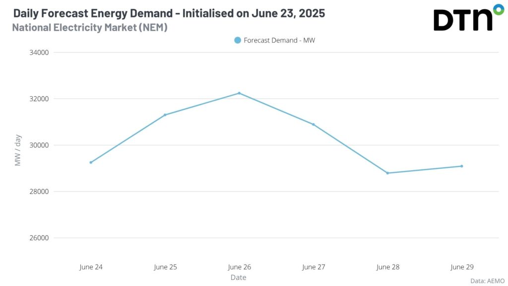
Image: Daily forecast energy demand according to the AEMO forecast initialised on June 23.
Wind farms are harnessing the power of the cold front, with the NEM recording consecutive record wind generation over a day on Monday and Tuesday, with 191,268 and 211,084 MWh, respectively. Along with that, Victoria had its highest renewable energy output on record on Tuesday, June 24, with 100,565 MWh produced by wind, solar and hydro.
DTN APAC has grown to become the outright leader within the Australian energy market, serving wind, solar, hydro, trading, utilities and network companies.
You can’t control the weather, but you can gain precision insights to optimise your response. What lights us up is providing your energy business with tailored weather information to reduce your risk and keep you moving ahead of the curve.
Our services cover all aspects – from wind and solar generation to demand forecasts, wholesale markets to retail so, no matter where your company sits, we have solutions for you. We have worked closely with market participants to create products that meet the evolving needs of the sector, aiming to increase safety and profitability for our customers.
Your customisable Energyzone interface can assess heat/heatwave potential from 14 days out to 12 months. It allows you to benefit from specialised indices for CDD/HDD/apparent temperature/sunshine hours to help accurately predict the demand for electricity. This, along with high-resolution modelling and local knowledge, gives you the most precise information available to make the critical decisions that bolster your production.
Benefit from the timely delivery of accurate weather information, allowing informed and effective decision-making.
Learn more about our large range of industry leading products and services or email us at sales.apac@dtn.com




