
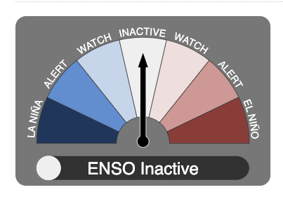
The Bureau of Meteorology has officially declared El Niño over and the El Niño Southern Oscillation (ENSO) is now inactive for the first time since 2021, meaning there is no immediate sign of either an El Niño or a La Niña event.
“El Niño has ended and the El Niño–Southern Oscillation (ENSO) has returned to neutral. Climate models indicate ENSO will likely continue to be neutral until at least July 2024,” the BoM said in a statement on Tuesday.
“As the current global ocean conditions have not been observed before, inferences of how ENSO may develop in 2024 that are based on past events may not be reliable.”
The story of the 2023/24 El Niño event
Many Australians tend to associate El Niño with uniformly dry weather across the country, however this is not always the case and was definitely not the case over the duration of the 2023/24 El Niño event.
- El Niño’s influence on Australia’s climate was clear in late winter and early spring 2023, leading to the driest three-month period on record across Australia from August through to October 2023.
- The swift end to a moderate Australian snow season as well as severe rainfall deficiencies in large parts of southern Australia were just two clear-cut effects of the widespread dry conditions.
This remarkable dry period was then followed by widespread rain and thunderstorms across eastern and southeastern Australia during summer, highlighting that El Niño’s influence is strongest during spring and that it does not always lead to dry weather, especially when other climate drivers were at play.
A myth busted: El Niño years always mean dry summers
The map below shows the summer rainfall deciles during 14 El Niño years, showing that during El Niño years much of the country can expect average to above average rainfall. Note just how much of the country is close to average during the summer months, with some parts even seeing a wetter than normal tendency.
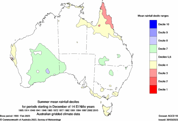
Image: Summer mean rainfall deciles for 14 El Niño years, source: BOM
The return of wet weather in summer and Autumn was caused by the waning influence of El Niño, a positive phase of the Southern Annular Mode (SAM) and record-breaking warm sea surface temperatures off the east coast of Australia.
The map below shows that during the during the last five months that much of Australia saw above average rainfall, except the west coast.
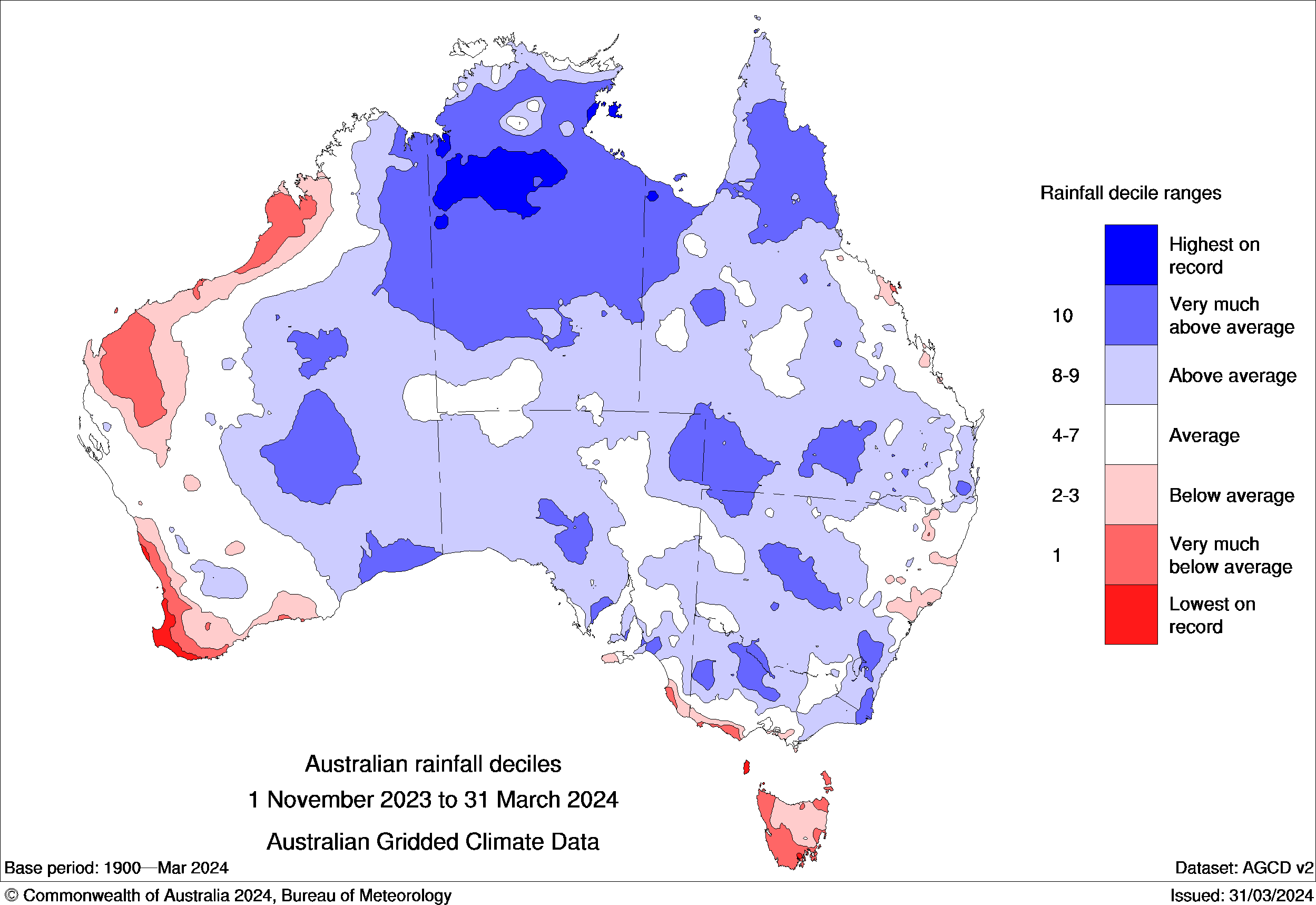
Source: BoM.
The record-breaking sea surface temperatures across northern Australia, also led to an unusually active end to the tropical cyclone season despite El Niño. Eight tropical cyclones have formed in the Australian region so far this season, with computer models showing another two possible in the next week. The average for an El Niño is around seven.
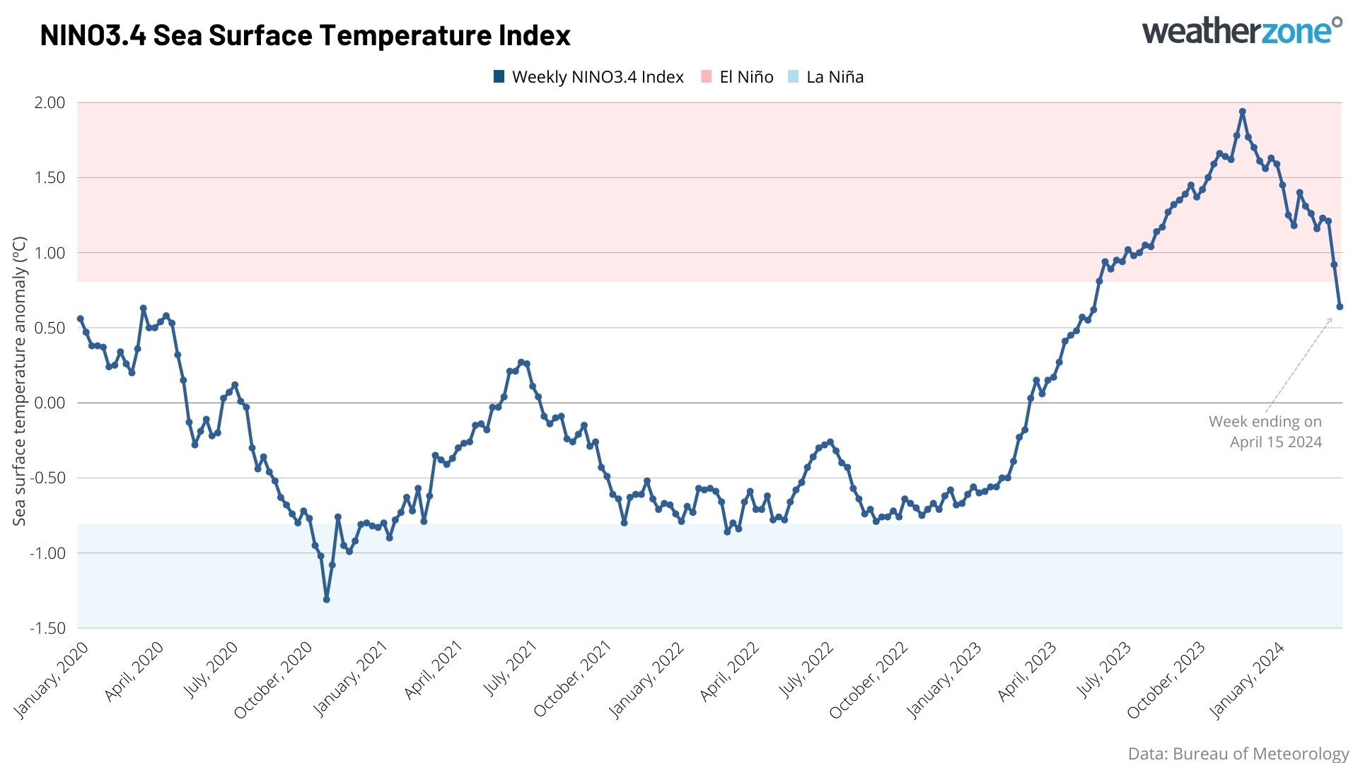
The latest weekly Nino 3.4 value up to Monday, April 15, was +0.64°C, which has fallen below the El Niño threshold of +0.8°C. This means that the Pacific Ocean has returned to a neutral or normal phase, no longer influencing Australia’s weather.
El Niño was declared in mid-September 2023 by the Bureau of Meteorology and as mentioned, it quickly became a strong event during November and December 2023. This contributed to the driest three-month period on record for Australia between August and October 2023.
While the BoM forecasts that neutral conditions should continue through the remainder of autumn and into winter, three out of seven global meteorological organisations give La Niña of developing later this year.
The US Climate Prediction Centre (CPC) and Columbia University’s International Research Institute for Climate and Society (IRI) give La Niña an 80 percent chance of occurring by late winter/early spring and an 86 percent chance in late spring and early summer.
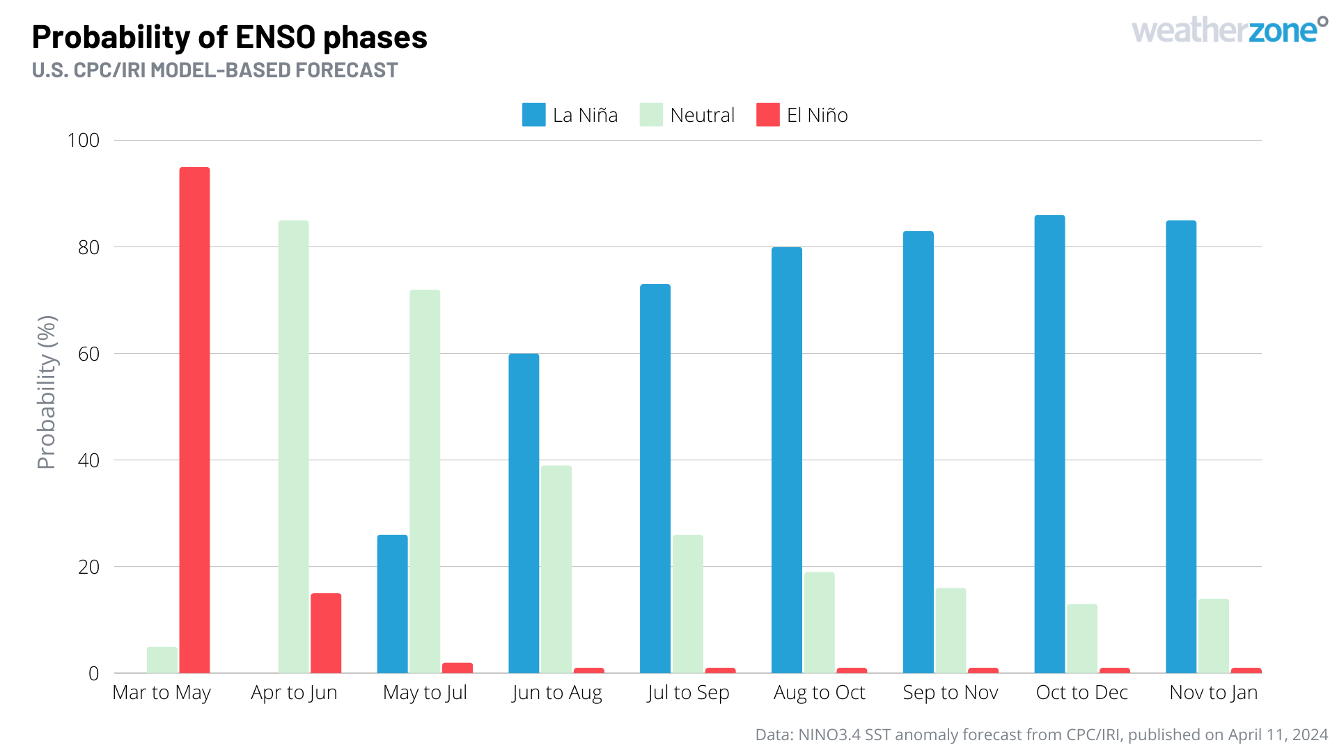
Image: El Niño-Southern Oscillation (ENSO) forecast for the next 10 months, according to the U.S. CPC/IRI. The blue bars show the probability of La Niña occurring during each three-month period, with grey and red bars representing the probability of neutral and El Niño, respectively. Source: CPC/IRI
The warm oceans and humid atmosphere that are associated with La Niña typically drive above average rainfall and cloud cover across much of Australia, especially between winter and early summer.
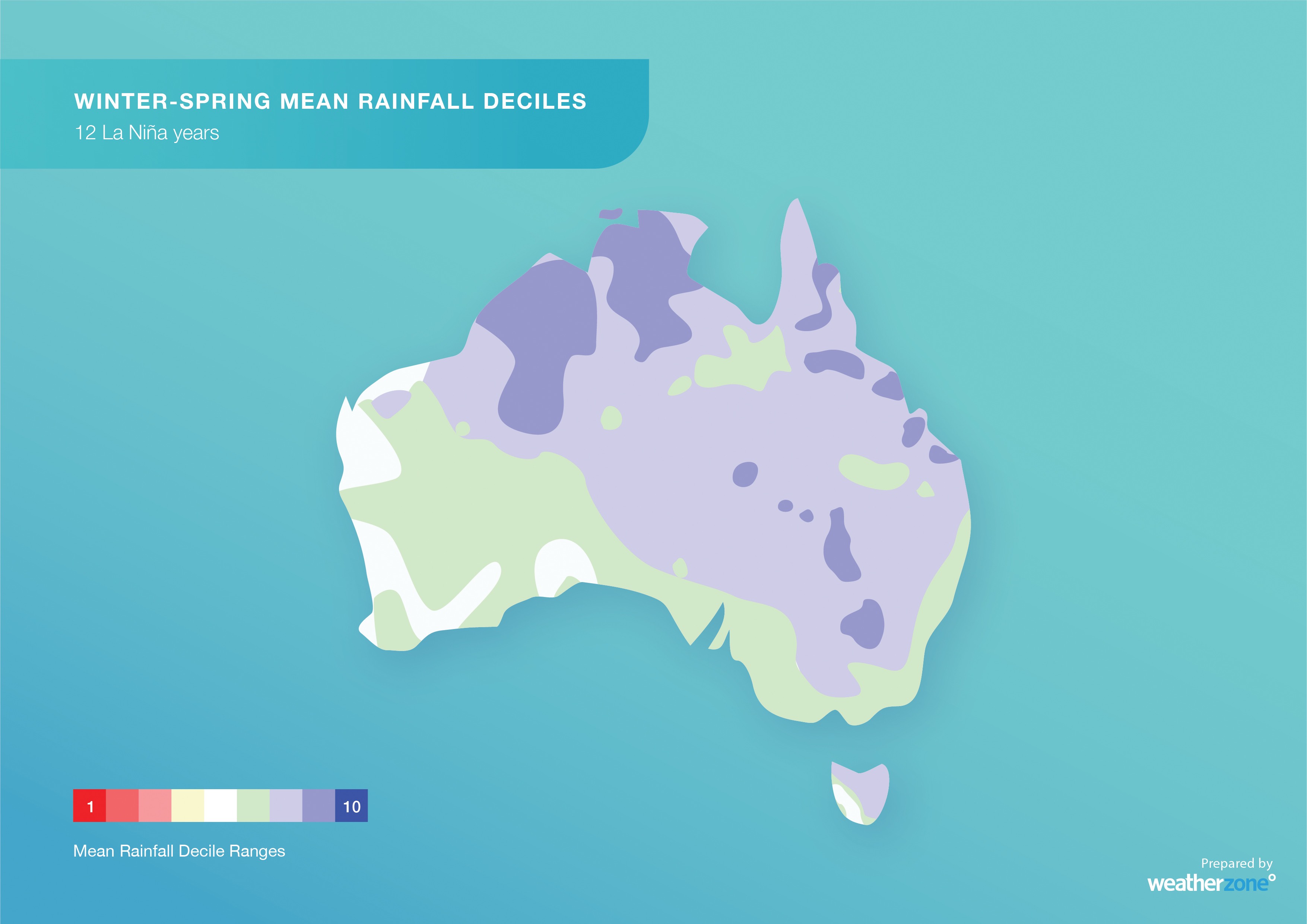
Image: Observed rainfall deciles during 12 past La Niña winter-spring periods combined, showing that large areas of Australia typically experience above-average rain during La Niña.
You can read more about the impacts of La Niña on Australia’s weather here.


