
New data released overnight gives La Niña nearly a 90% chance of returning this spring, as the ocean continues to cool in the tropical eastern Pacific.
The Pacific Ocean has been in an El Niño phase since September 2023, peaking between November to December 2023 at about 2°C, which is classified as a strong event. The latest weekly Nino 3.4 value up to Monday, April 8, was 1.04°C, which is still above the El Niño threshold of +0.8°C.
While the ocean temperatures remain in El Niño thresholds, the atmosphere is barely showing any signs of an El Niño, with weaker trade winds, enhance cloud over the central tropical pacific and drier conditions over Indonesia. Most models suggest that the Pacific Ocean will return to a neutral phase in the next month, despite El Niño having little influence on Australia’s weather recently.
Looking ahead, the US Climate Prediction Centre (CPC) and Columbia University’s International Research Institute for Climate and Society (IRI) show that the probability of La Niña increases later this year. Their predictions give La Niña an 80 percent chance of occurring by late winter/early spring and an 86 percent chance in late spring and early summer.
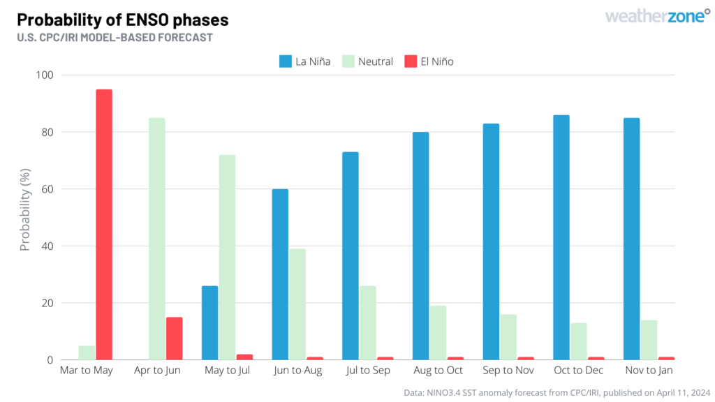
Image: El Niño-Southern Oscillation (ENSO) forecast for the next 10 months, according to the U.S. CPC/IRI. The blue bars show the probability of La Niña occurring during each three-month period, with grey and red bars representing the probability of neutral and El Niño, respectively. Source: CPC/IRI
While many international models are hinting at the return of La Niña this year, the Australian model suggests that we will be in neutral ENSO conditions during late winter and early spring.
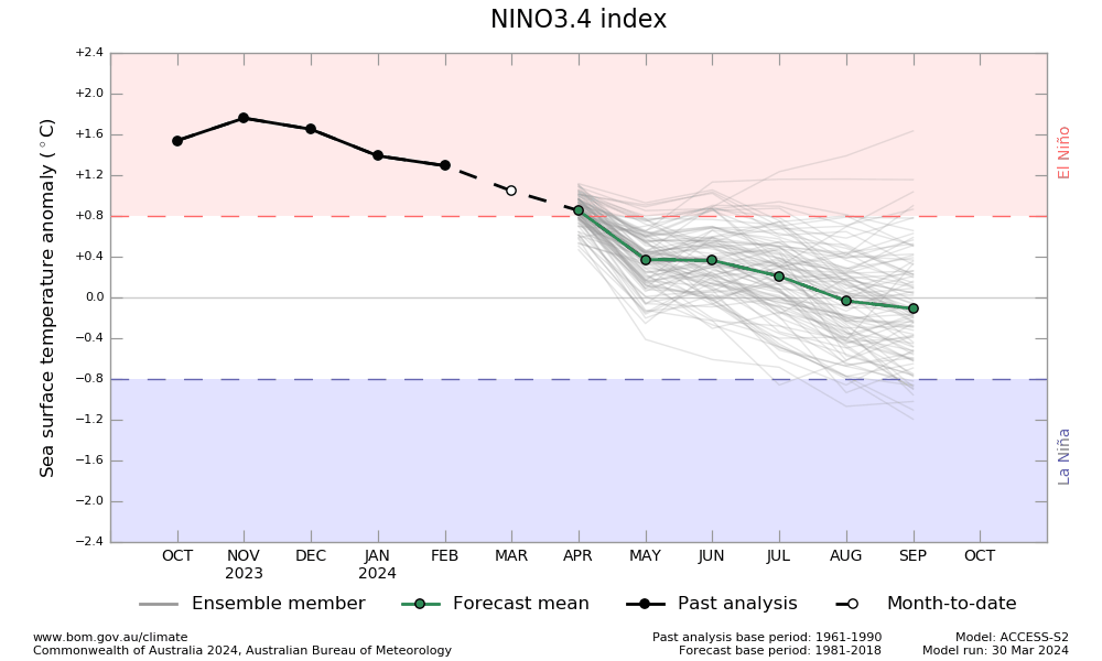
Image: ENSO forecast for the next six months, based on the Nino-3.4 temperature anomaly, according to ACCESS-S2 Source: Bureau of Meteorology, issued on March 30.
The graphic below shows that a pool of unusually cold water has been growing over the last month in the eastern tropical Pacific Ocean, hinting that the foundations of a La Niña event may be lurking beneath the surface.
Image: Pacific Ocean Sea surface temperature anomalies on March 12 to April 10, 2024. Source NOAA
The large supply of abnormally cool water in the eastern tropical Pacific Ocean does add some weight to the possibility of La Niña returning this year. However, it is too early to know with much certainty whether this will happen or not.
What are the chances of an La Niña this year when we look back at history?
Following a strong El Niño event, La Niña has double the likelihood of returning in the following year. Prior to 2023, the U.S. CPC have recorded eight strong El Niños dating back to 1950, of which five were followed by a La Niña in spring.
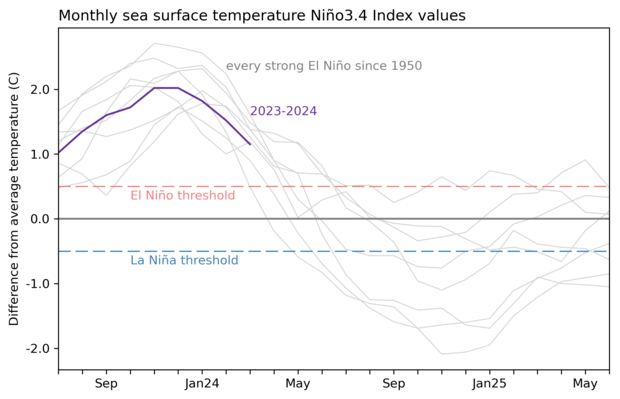
Image: The grey lines in this graph show the two-year history of sea surface temperature anomalies in the Niño-3.4 region of the tropical Pacific Ocean for all strong El Niño events since 1950. The current event (2023 to 2024) is shown by the purple line. Prior to 2023, five out of eight Strong El Niño ’s returned to La Niña in spring. Graph is based on monthly Niño-3.4 index data from CPC using ERSSTv5. Source: NOAA CPC / Emily Becker.
During the last 5-years we have seen three consecutive La Nina (2020-2023), and an El Nino, with the possibility for a fourth La Nina in 2024. This would be the first time this sequence was to occur in the history of Australia’s record keeping. The most similar years are listed below;
- 2007-2009 La Niña, 2009 El Niño, 2010-12 La Niña
- During 1970-75 there was a similar run with two back-to-back La Niña’s followed by one El Niño then a triple La Niña.
- Between 1906 and 1911 we saw 5 La Niña’s in a row followed by one El Niño
An important caveat with any ENSO outlook made at this time of year is that predictions are less reliable prior to winter in the Southern Hemisphere. This seasonal dip in model reliability is called the autumn predictability barrier in the Southern Hemisphere (spring predictability barrier in the Northern Hemisphere) and means the current outlook should be treated with caution. In the coming months, we will watch the ocean temperatures in the Pacific and the international climate models closely.
The shifting climate is bringing increased complexity and greater risks to businesses worldwide. We are here for you, delivering trusted weather solutions to optimize your operations and profitability.
DTN APAC is a diverse team, with global forecasting, product development and analytics expertise. Couple this with extensive industry experience spanning Aviation to Energy, and we are primed to assist you in strengthening your response to weather
impact.
We work hard to identify your operational pressures and tailor our services and products to meet your needs. Concise communication, giving you full situational awareness exactly when you need it, is our focus. We want to reduce weather risk in your operations, every day.
We deliver clear and comprehensive weather data, personalised risk assessments and briefings to you and your team, so that your critical decisions can be made with confidence.
We are available 365 days a year, so you always have the timely guidance you require, especially when severe conditions hit.
You have our insights to rely on to see you through complex situations, minimising potential loss of profit and maximising the safety of your staff and assets. For more information, please contact us at apac.sales@dtn.com.


