
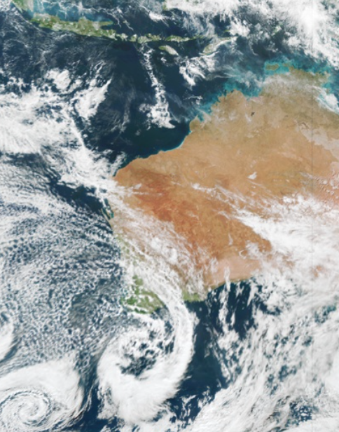
Wild and windy weather has begun in southwestern WA, as a low-pressure system lingers off the southern coastline. Damaging winds were recorded in the southwest of WA on Monday morning, with gusts reaching 120 km/h at Cape Leeuwin, 96 km/h at Busselton Jetty and 95 km/h at Cape Naturaliste between 1am and 4am. These strong winds are set to […]

Australia’s climate varies greatly throughout the eight states and territories, which certainly keeps Australian businesses on their toes. In some parts of Australia, winter is marked with frosts and freezing temperatures, while heatwaves and extreme temperatures are frequent in the summer months. The huge contrast in the seasonal temperatures in Australia is a challenge for businesses in the energy market. Accurate temperature forecasting […]

Today is the second morning Sydneysiders have woken up beneath a thick blanket fog. The low visibility caused by this morning’s fog has created issues and disruptions to operations and services for several businesses, including ferries, ports and aviation. Unfortunately, the fog lasted well into the morning on both occasions, reducing visibility until after 10am. Sydney’s fog rarely forms in the city Centre, but instead arrives […]

Rain is going to sweep across a broad area of Queensland and NSW during the next 4-5 days, with thunderstorms and flooding possible in some areas. Moisture-laden air interacting with a low pressure trough has been causing cloud, showers and the odd thunderstorm to develop over eastern Australia on Wednesday. The days of cloud and rain are likely to cause […]

There are growing signs that much of Australia will experience unusually cold and wet weather this winter and spring, with a negative Indian Ocean Dipole (IOD) emerging in recent weeks. Climatologists have been keeping a close eye on the Indian Ocean during the last couple of months. In May, there were early signs that […]

Cloud, rain and thunderstorms are expected to impact a large area of Australia this week, as a northwest cloudband and low-pressure system sweep across the country. Northwest cloudbands are vast layers of cloud which stretch from Australia’s northwest to southeast. They form when humid and warm tropical air over the Indian ocean moves across Australia, producing cloud as the air rises over the cooler air in the mid-latitudes. The oceans off the northwest shelf of Australia are currently warmer than […]

A deepening Tasman Low will bring a burst of wind, rain, and large waves to parts of Tasmania, Victoria, and NSW during the next 3 days. The low could be seen clearly in satellite images last night, sitting roughly 350 km to the east of Victoria and is expected to deepen today and tomorrow. WAVES […]

As the days get shorter and the temperatures begin to drop ahead of winter, fog becomes an imminent risk for port and offshore rigs safety and operations. Fog can occur at any time of the year, although they are most prevalent during the winter months. Fog forms overnight when temperatures cool and the humidity of air increases significantly, such […]

Bankstown has experienced its equal coldest day in 38 years today, with the maximum temperature unable to break above 10 degrees. Sydney’s maximum temperature also struggled, with the capital shivering through the coolest day in 37 years. A freezing air mass has wrapped around a cut-off low and into NSW, bringing icy temperatures and spreading low level snow across NSW. In fact, the ski resorts in the Snowy Mountains have […]

Australia’s tropical cyclone season is officially underway, but we may not see much activity for few months yet. The season runs from November to April, and for mining operators and businesses across northern Australia, 2026-27 is shaping up to be a season where the headline numbers and the real risk may not line up. On […]

A positive Indian Ocean Dipole is underway, but this one is unlikely to deliver the textbook dry spring and summer that businesses have come to expect from the pattern. The Bureau of Meteorology officially declared a positive IOD on Tuesday, October 27, which typically like El Niño can cause drier and warmer conditions over parts of […]

Waters off Indonesia have cooled in recent weeks, an indication that a positive Indian Ocean Dipole (IOD) event could be developing. It’s an important climate driver for Australia, and it could shape rainfall and temperatures heading into summer, with flow-on effects for farmers, energy and other industries. What is the Indian Ocean Dipole? The IOD […]

Leonora, WA, had its wettest September day on record earlier this month. Three weeks later, more than 1.3 million lightning pulses were detected within 800 km of the town in 48 hours. Why is a stalled trough delivering storms to mining country, and what it could mean for operations? The DTN Total Lightning Network detected […]
