
There are growing signs that much of Australia will experience unusually cold and wet weather this winter and spring, with a negative Indian Ocean Dipole (IOD) emerging in recent weeks.
Climatologists have been keeping a close eye on the Indian Ocean during the last couple of months. In May, there were early signs that a negative IOD could develop this winter. This now looks more likely, and we are already starting to feel its impacts.
What is the Indian Ocean Dipole?
The IOD is a large-scale circulation that occurs in the Indian Ocean, much like the El Niño Southern Oscillation (ENSO) in the Pacific Ocean.
The IOD is characterised by remarkably different sea surface temperatures in the western tropical Indian Ocean (near the Arabian Sea) and the eastern tropical Indian ocean (off the northwest shelf of Australia).
When this sea surface temperature gradient is large enough across the Indian Ocean, it drives rising and descending moisture and air on both sides of the Indian Ocean basin (figure 1).
There are 3 phases of the IOD: negative, neutral and positive. Each phase dramatically impacts Australia’s weather. In general, negative IOD events are cool and wet for Australia (figure 1), while positive IOD events are drier and warmer.
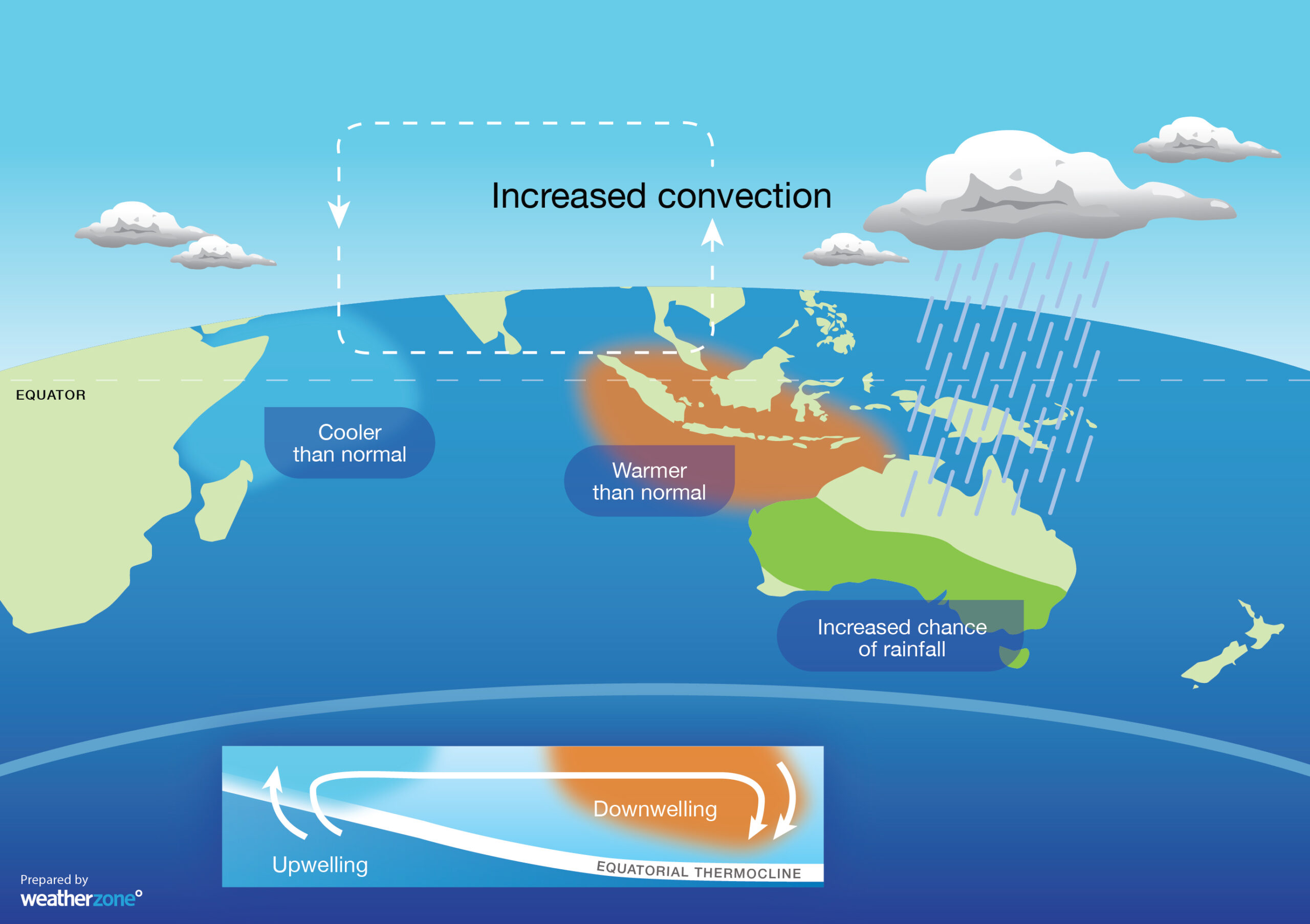
Figure 1: Negative Indian Ocean Dipole (IOD) and the impacts on Australia.
While the IOD is currently neutral (average conditions for Australia), this week’s mean IOD value is minus 0.7, which is below the negative IOD threshold of minus 0.4.
As it turns out, the weekly mean IOD value has now remained below the negative IOD threshold for five consecutive weeks.
For a negative IOD event to be officially declared, the weekly mean IOD value must stay below this threshold (-0.4) for eight consecutive weeks.
Some seasonal computer models indicate that a negative IOD will be officially declared this winter and persist into spring. Of the five global climate models surveyed, four are predicting a negative IOD in August and all five are predicting a negative IOD in September.
How does the IOD affect Australia’s weather?
A negative IOD can have a big impact on Australia’s weather during winter and spring.
The pattern of sea surface temperatures during negative IOD events typically cause more atmospheric moisture to flow over Australia from the northwest.
This moisture can fuel vast northwest cloudbands, which can cause widespread rain, thunderstorms and flooding during winter and spring (figure 2).

Figure 2: Winter spring mean rainfall during 11 negative IOD events.
The increased cloud cover caused by negative IOD episodes can also limit daytime heating over Australia. This often causes below-average daytime temperatures across large areas of the country during winter and spring (figure 3).

Figure 3: Winter-spring mean maximum temperature deciles during 11 negative IOD years
But while days are often colder for some areas of Australia during a negative IOD, nights are usually near-average to warmer-than-average in winter and spring. This is because clouds act like a blanket at night and help trap some of the previous day’s warmth near the ground (figure 4).

Figure 4: Winter-spring mean minimum temperature deciles during 11 negative IOD years.
In general, extreme cold days are more likely across southeastern Australia during a negative IOD, while extreme cold nights are less likely.
The IOD can also influences the quality and quantity of snow in southeastern Australia. The combination of more rain and lower daytime temperatures during a negative IOD typically means a better snow season in the Alps.
Already feeling the IOD
While a negative IOD hasn’t yet been declared, Australia is already feeling its effects.
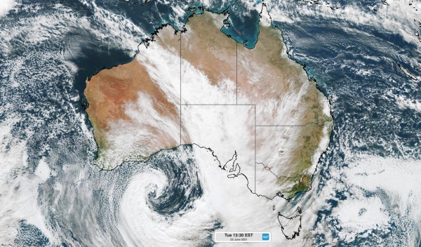
Warmer-than-average sea surface temperatures to the northwest of Australia are fueling a large northwest cloudband this week (figure 5).

Figure 5: Visible satellite imagery on Tuesday, June 22 at 1:30pm EST showing a northwest cloud band streaming across Australia.
This moisture has already caused flooding in parts of Western Australia during the last 48 hours. More flooding is likely as the rain spreads further east, with part of every state and territory likely to see some decent rain this week.
These northwest cloudbands, and their impacts, are likely to be a prominent feature during the next several months. For more information on the negative IOD and how this may impact your business, please contact us at apac.sales@dtn.com.




