
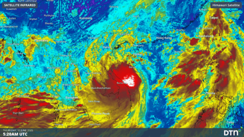
Gusty winds and heavy rain are impacting parts of Vietnam and southern China as the first tropical storm of the season, named Wutip, closes in on Hainan Island. The satellite loop below shows Tropical Storm Wutip, which translates to “butterfly” in Cantonese, spinning to the east of Da Nang, Vietnam. Video: Satellite loop of Tropical […]

Victoria just experienced it’s warmest autumn on record, but why? Average temperatures across Victoria were 1.90°C above average throughout autumn 2025, which narrowly exceeded the old record set in 2016. Image: Temperature anomalies in Victoria from 1910 to 2025. Source: BoM. Australia as a whole was 1.41°C above average in autumn 2025, which made it […]
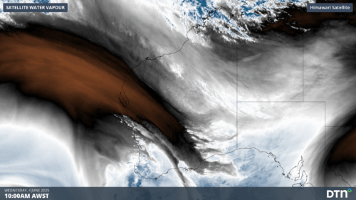
Perth just registered its wettest day since July last year and more rain is in the way for Australia’s west coast in the coming days. The first five months of 2025 were unusually dry in Perth. The city only received 96 mm of its 170 mm average for the period from the start of January to […]
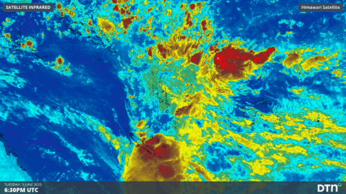
Intense rainfall and thunderstorms impacted New Caledonia early this morning, with more to come for other South Pacific islands to the east. Flooding rainfall and intense thunderstorms in New Caledonia The satellite imagery below shows an area of convergence into a low pressure trough moving over New Caledonia early on Wednesday, June 4. This convergence […]

Abnormally high fire risk is anticipated across parts of South Australia and Victoria this winter as the ongoing drought causes a seemingly endless 2025 fire season in southern Australia, with reduced risk across northern Australia with recent wet months. Increased Risk of Fire for southern Australia Australia’s official seasonal bushfire outlook for winter 2025 was […]
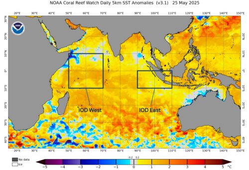
Warm sea surface temperatures near Indonesia are expected to heat up further over winter, possibly triggering a negative Indian Ocean Dipole (IOD) event. What is the Indian Ocean Dipole (IOD)? The IOD is an index that measures the difference in sea surface temperatures across the equatorial Indian Ocean. A negative IOD occurs when cooler-than-average water […]
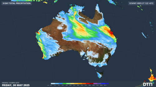
Unseasonably heavy rain has drenched parts of northern WA and the NT, with Queensland next in line for soaking rain in the next few days. A deep stream of tropical moisture originating over the Indian Ocean is fuelling a massive northwest cloud band across Australia this week. This thick cloud band has been producing exceptionally […]

A powerful Tasman low and vigorous cold front are generating two strong south swells that will bring large waves to coastal NSW in the coming days. The satellite loop below shows a deep Tasman low spinning halfway between NSW and New Zealand. The satellite imagery also shows a powerful cold front crossing well to the […]

A huge dust storm and gusty westerly winds whipped up by a powerful cold front crossing southeastern Australia have led to airport disruptions and diversions on Monday and Tuesday. A powerful cold front passing over drought-affected areas of SA and Victoria on Monday caused dry topsoil to become airborne as strong winds scoured the parched […]

Australia’s tropical cyclone season is officially underway, but we may not see much activity for few months yet. The season runs from November to April, and for mining operators and businesses across northern Australia, 2026-27 is shaping up to be a season where the headline numbers and the real risk may not line up. On […]

A positive Indian Ocean Dipole is underway, but this one is unlikely to deliver the textbook dry spring and summer that businesses have come to expect from the pattern. The Bureau of Meteorology officially declared a positive IOD on Tuesday, October 27, which typically like El Niño can cause drier and warmer conditions over parts of […]

Waters off Indonesia have cooled in recent weeks, an indication that a positive Indian Ocean Dipole (IOD) event could be developing. It’s an important climate driver for Australia, and it could shape rainfall and temperatures heading into summer, with flow-on effects for farmers, energy and other industries. What is the Indian Ocean Dipole? The IOD […]

Leonora, WA, had its wettest September day on record earlier this month. Three weeks later, more than 1.3 million lightning pulses were detected within 800 km of the town in 48 hours. Why is a stalled trough delivering storms to mining country, and what it could mean for operations? The DTN Total Lightning Network detected […]
