Intense rainfall and thunderstorms impacted New Caledonia early this morning, with more to come for other South Pacific islands to the east.
Flooding rainfall and intense thunderstorms in New Caledonia
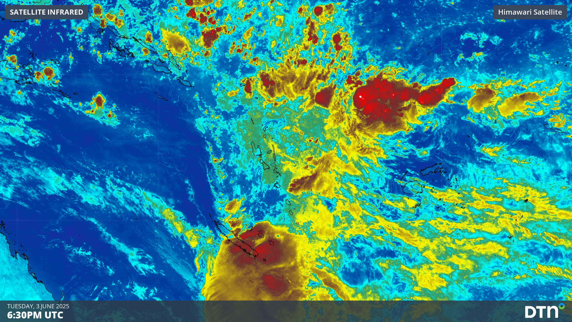
The satellite imagery below shows an area of convergence into a low pressure trough moving over New Caledonia early on Wednesday, June 4. This convergence of moist east to northeast winds (to the east of the trough) and drier westerly winds (to the west of the trough) triggered these intense thunderstorms and heavy downpours over the French territory.
Video: satellite loop and detected lightning on Wednesday morning, June 4 over New Caledonia as seen on DTN’s Stormtracker.
According to Météo France Nouvelle-Calédonie, the heaviest falls were recorded within a period of six to 12 hours on the morning of Wednesday, June 4, including:
- 219mm at Poindimié
- 206mm at Yaté (including 99mm in one hour and 171mm in three hours)
- 167mm at Touho
- 124mm at Canala
The notable heavy rainfall totals exceeding 100mm were mostly located on the northeastern coast of Grande Terre, the main island. This is due to the mountain range that runs the length of the island, causing the moist Pacific Ocean winds to precipitate intensely.
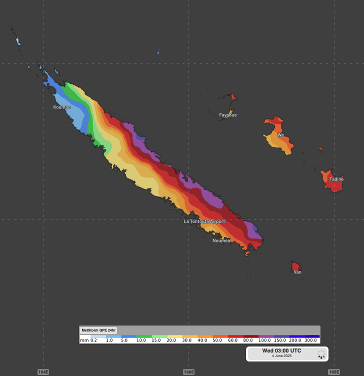
Image: DTN MetStorm QPE showing estimated observed rainfall over New Caledonia during the 24 hours ending at 2pm NCT on Wednesday, June 4, 2025.
Thunderstorms affected the whole archipelago, with 22mm falling at Nouméa, the capital city. Strong wind gusts reaching 47 knots (87km/h) were also recorded at Nouméa and Phare Amedée, an offshore lighthouse island.
300,000 lightning strikes were also recorded within 500km of Nouméa over the past 36 hours, according to the DTN Total Lightning Network.
Flooding and thunderstorms coming for other South Pacific nations
The convergence line that impacted New Caledonia is starting to impact Vanuatu this afternoon. Less intense rainfall is expected over the volcanic archipelago, but severe thunderstorms could still deliver 30-50mm of rain in short periods of time this Wednesday afternoon and evening – possibly causing flash flooding and disruptions.
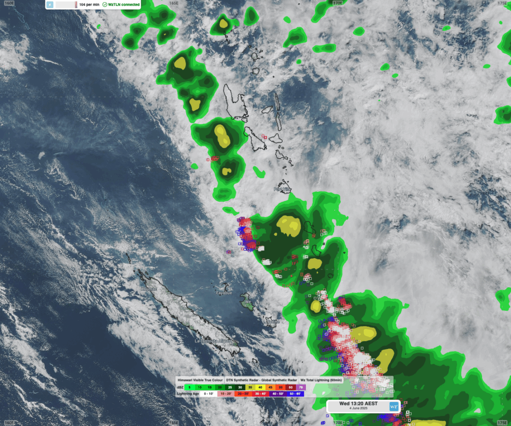
Image: In a region where radar coverage is sparse, the DTN Synthetic Radar and Total Lightning Network shows where adverse weather is starting to impact Vanuatu on the afternoon of Wednesday, June 4, 2025.
A more prolonged, but less intense, period of rainfall is expected for Fiji, lasting between Thursday morning and Friday afternoon. Tonga is forecast to receive more intense rainfall later on Friday and on Saturday morning.
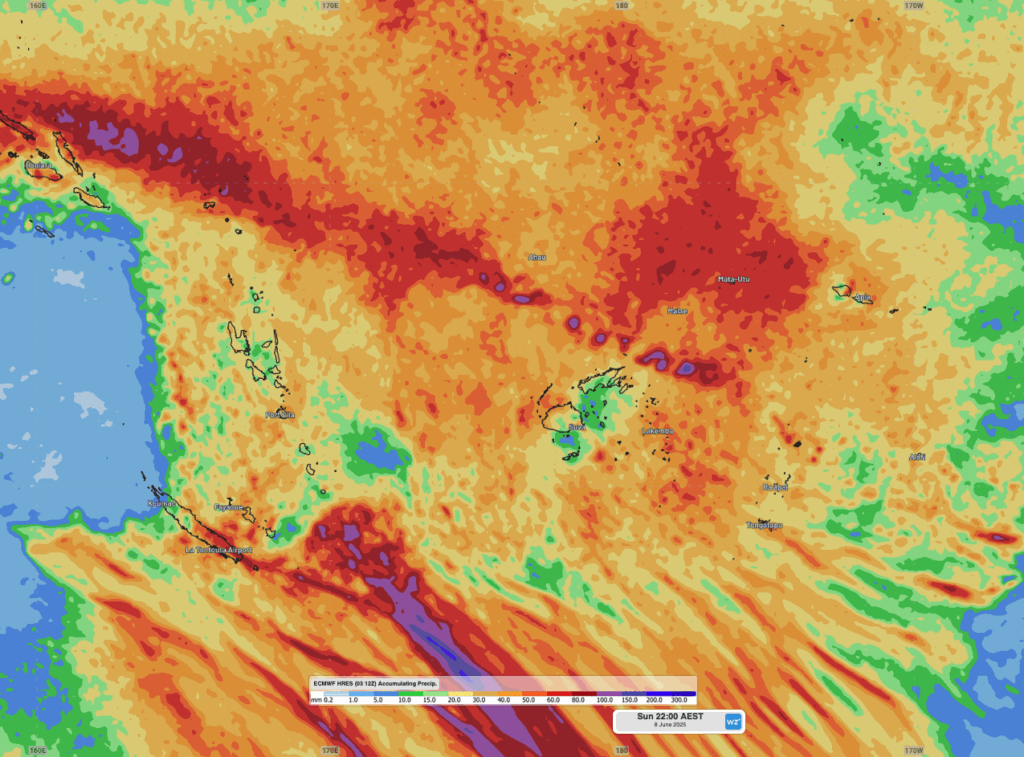
Image: forecast accumulated rainfall across the South Pacific to 10pm AEST on Sunday, June 8.
Other South Pacific islands can also expect periods of rain between late this week and early next week. The convergence of winds is set to weaken as the week goes on, so the rainfall is not expected to be intense, but will be reminiscent of the wetter summer months.
How DTN APAC services the South Pacific
The South Pacific radar and weather observation network is sparse, leaving many locations and businesses in the dark when it comes to weather alerting. DTN APAC offers a powerful and accurate remote sensing array that will alert you of oncoming lightning and heavy rainfall, without needing to install costly radar technology.
The DTN Total Lightning Network
Our Total Lightning Network is the intelligent lightning solution that goes above and beyond to alert lightning and increase your lead time before the storm hits.
We utilise a vast global sensor network, created with our partner Earth Networks. Over 1200 sensors in 40+ countries provide a worldwide view of both intra-cloud (IC) and cloud-to-ground (CG) lightning strikes, enabling businesses to plan and respond with the most precise insight available. Our system can detect and calculate strike locations with incredible accuracy, offering real-time lightning mapping for a comprehensive view of storm activity.
Offering unsurpassed accuracy, with real-time sensing to <200m, we integrate with your existing systems to keep your enterprise operating within your defined severe weather thresholds. Our technology also helps monitor radiation from electrical discharges and ensures every lightning flash is accounted for.
Leave nothing to chance. Be confident working outdoors with the most sophisticated lightning alerting system, delivering intelligence to any device across your business network. Whether you need a personal lightning alerting tool for individual safety or enterprise-wide monitoring, our solution is designed to emit timely alerts and protect your operations.
DTN’s Synthetic Radar technology
DTN’s Synthetic Radar is a satellite-derived, gridded nowcasting system. This ensures that no matter where you are on the globe, you will have access to a precision radar-like system that can rapidly inform your critical business decisions.
Working in conjunction with DTN APAC’s Stormtracker GIS system, the synthetic radar provides full situational awareness of any severe weather event that presents risk to your business. Severe weather alerts enable you to foresee the intensity and duration of events, so you can prioritise the safety and preparation of your staff and assets.
Whatever the weather, we provide the insights to help keep you and your team safe, productive and profitable.
Install your own weather station
The ObsConnect Weather Station is DTN APAC’s turn-key solution – simple to install with ongoing maintenance support provided, and easily scaled to serve your business requirements.
Our weather sensor and data hub are expertly assembled in a ready-to-deploy ruggedized cabinet so you can install the Weather Station easily, anywhere. Scheduled verification and preventative maintenance ensure reliability for your peace of mind, while DTN’s MetConsole Cloud data system facilitates seamless integration into your existing online products.
The compact, all-in-one sensor is the first of its kind to integrate all measurements into a single, intelligent package. It offers precise quantification with proven accuracy and efficiency. You will always have the situational data you need, exactly when you need it.
Reduce the time and costs associated with deploying networks of field hardware. The plug-and-play nature of its singular design ensures no specialty tools are required for installing the Weather Station on site, and your data is secure, validated and easily visualised.
Learn more about our large range of industry leading products and services or email us at sales.apac@dtn.com


