Unseasonably heavy rain has drenched parts of northern WA and the NT, with Queensland next in line for soaking rain in the next few days.
A deep stream of tropical moisture originating over the Indian Ocean is fuelling a massive northwest cloud band across Australia this week.
This thick cloud band has been producing exceptionally heavy rain for this time of year, delivering 100mm in 24 hours at places that typically see less than 20 mm during all of May.
Image: Visible satellite images showing a large northwest cloud band over Australia on Tuesday, May 27, 2025.
The heaviest rain over the last two days has focussed on the NT and northern WA, where some places had their wettest May day on record. Some of the standout 24-hour totals from the past couple of days included:
- Broome, WA: 100.6 mm – heaviest May daily rain since 1997
- Kalumburu, WA: 111.6 mm – wettest May day on record (data to 1942)
- Wyndham, WA: 54.8 mm – wettest May day on record (data to 1961)
- Tindal, NT 179.8 mm – wettest May day on record (short historical data)
- Rabbit Flat, NT: 77.6 mm – wettest May day on record (data to 1970)
- Alice Springs, NT: 40.4 mm – heaviest May daily rain since 1993
Some of these areas rarely see rain in May. Tindal, which collected almost 180 mm in 24 hours, has a long-term May monthly average of just 2 mm.
This has been more than enough rain to cause flooding across the outback, prompting flood watches in the West Kimberley and Fitzroy Rivers and Desert catchments in WA, and the MacDonnell Ranges, Tanami, Central and Simpson Desert catchments in the NT.
The focus of this system’s heaviest rainfall will now shift further east and soak a broad area of Queensland between Wednesday afternoon and Saturday.
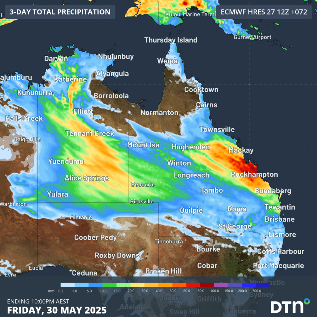
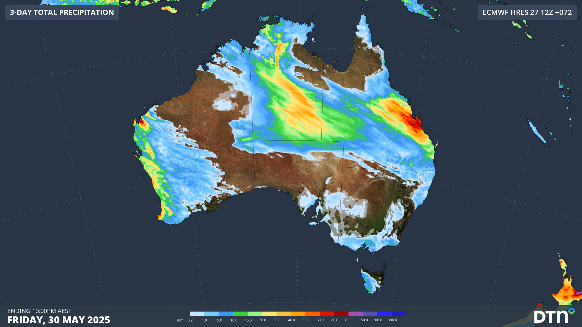
Image: Forecast accumulated rain during the 72 hours ending at 10pm AEST pm Friday, May 30, 2025.
Queensland is not expected to see as much rain as the wettest places in the NT and WA over the past few days. However, the rain will be widespread and may cause some localised flooding in the state’s flat interior.
Areas of flooding could affect parts of northern WA, the NT and Queensland through the back half of this week. Be sure to check the latest flood watches and road closures before travelling on outback roads.
How DTN APAC can help
We help businesses in Australia, Asia and the Pacific prepare for severe weather and storms, across sectors including Roads and Transportation, Emergency Services, Mining, Insurance and Energy.
The DTN APAC Flood Risk System (FRS)
DTN APAC, delivers the Flood Risk System (FRS) to provide flood risk visibility. You can now easily visualise precipitation, and access rapid-update forecasting, across multiple sections of your site with the FRS geofenced alerting system. Gain a more precise determination with DTN APAC’s advanced geospatial technology creating hundreds of virtual ‘weather stations’ for each monitored section or culvert.
Rainfall is measured across each of your established catchments, with alerting calibrated to their individual thresholds. Alerts are raised when thresholds for any section are approaching or have been breached. This gives you targeted risk visibility to inform your assessment, operational response and emergency management.
The FRS can be integrated into your existing DTN APAC interface, or your own monitoring and control systems. Real-time monitoring of each catchment’s predefined thresholds is coupled with forecasting of rain, so you can provide your team with the most up-to-date information on whether conditions will ease, continue, or worsen.
Learn more about our large range of industry leading products and services or email us at sales.apac@dtn.com


