
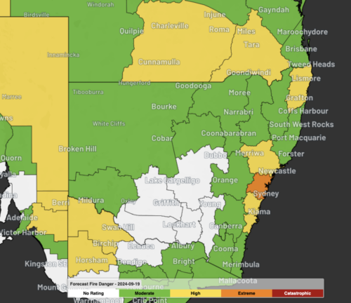
Sydney and the Illawarra will experience an early-season spike in fire danger ratings on Wednesday and Thursday as a burst of warm, dry and windy weather hits eastern NSW. While the start of this week was abnormally cold in Sydney and surrounding areas, temperatures will climb quickly over the next couple of days as warmer […]
This spring is shaping up to be an unusually warm and stormy season for Australia, with some parts of the country also likely to see an increased risk of fires. Australia has entered spring off the back of its warmest August and second warmest winter on record. The end of winter was also very dry […]

Nodes of polar air could soon be sweeping around the Southern Hemisphere as tropospheric weather patterns respond to recent warming in the stratosphere above Antarctica. Over the past fortnight, a pool of abnormally warm air disrupted the shape of the Southern Hemisphere’s stratospheric polar vortex. This phenomenon, which is called sudden stratospheric warming (SSW), occurred […]

SA has woken up to one of the coldest mornings in years, as temperatures plunged below freezing in some areas. The freezing cold morning was caused by a stubborn high pressure system sitting over SA and promoting clear skies over the state. The image below shows the cloud-free skies across SA earlier Wednesday morning, which […]
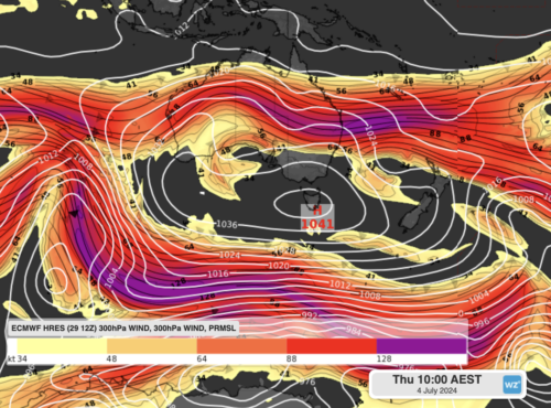
A blocking-high pressure system will park itself directly over Tasmania this week, and is forecast to become so strong, it challenges an Australian record. High pressure is crossing the Great Australian Bight after a cold front swept over southeastern Australia this weekend. While high pressure is common after a cold front, this particular high pressure […]

Today marks the date of the winter solstice in the Southern Hemisphere, making it Australia’s shortest day of the year based on time between sunrise and sunset. The winter solstice is an annual occurrence that falls in late-June each year. It marks the moment Earth’s Southern Hemisphere reached its furthest tilt away from the Sun, […]
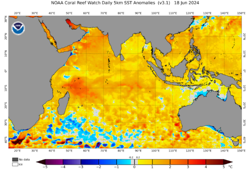
Early last month, we said that May would be a make-or-break month for the positive Indian Ocean Dipole (IOD) that could be forming this year. Turns out, it has most likely broken. A positive IOD occurs when the trade winds along the equator blow to the west instead of the east, causing an upwelling of […]

Australia has entered winter without any strong climate drivers influencing the country’s weather patterns. So, what can we expect to see across Australia during winter 2024? The term ‘climate drivers’ refers to patterns of sea surface temperatures and associated atmospheric conditions that influence Australia’s weather on a time scale of months to seasons. The main […]

A severe weather warning has been issued for damaging winds across all 11 weather districts in Tasmania on Friday, with dangerous gusts also likely in parts of Victoria, NSW and the ACT over the next two days. A strong cold front will cross southeastern Australia on Thursday and Friday, with an associated low pressure system passing […]

Australia’s tropical cyclone season is officially underway, but we may not see much activity for few months yet. The season runs from November to April, and for mining operators and businesses across northern Australia, 2026-27 is shaping up to be a season where the headline numbers and the real risk may not line up. On […]

A positive Indian Ocean Dipole is underway, but this one is unlikely to deliver the textbook dry spring and summer that businesses have come to expect from the pattern. The Bureau of Meteorology officially declared a positive IOD on Tuesday, October 27, which typically like El Niño can cause drier and warmer conditions over parts of […]

Waters off Indonesia have cooled in recent weeks, an indication that a positive Indian Ocean Dipole (IOD) event could be developing. It’s an important climate driver for Australia, and it could shape rainfall and temperatures heading into summer, with flow-on effects for farmers, energy and other industries. What is the Indian Ocean Dipole? The IOD […]

Leonora, WA, had its wettest September day on record earlier this month. Three weeks later, more than 1.3 million lightning pulses were detected within 800 km of the town in 48 hours. Why is a stalled trough delivering storms to mining country, and what it could mean for operations? The DTN Total Lightning Network detected […]
