

A key atmospheric indicator in the Pacific Ocean region has just surpassed the accepted threshold for El Niño, increasing the likelihood of abnormally dry and warm weather in Australia later this year. There has been a lot of talk recently about the potential for a strong El Niño in 2023. Most of this climate driver […]

Australia could see a lacklustre snow season this year if an anticipated unfavourable combination of Pacific and Indian Ocean climate drivers comes to fruition. The Australian snow season is notoriously fickle. Some years can see heaps of snow coming from multiple large snow-bearing systems (e.g. 1981, 1990, 2000), while other years barely have enough snow […]
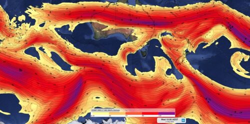
The Southern Annular Mode (SAM) – one of the main broad-scale mechanisms influencing Australia’s climate – just reached one if its strongest positive levels on record. What is the SAM? The SAM refers to the north-south displacement of the powerful westerly wind belt that flows around Antarctica throughout the year. These westerly winds carry the […]

Parts of southeast Qld just received more than a month’s worth of rain in 24 hours, with some areas on the Gold Coast collecting around 100 mm in six hours overnight. A low pressure trough and developing low pressure system produced thick clouds and widespread rain across southeast Qld and northeast NSW during Monday night […]

Heavy rain will soak parts of southeast Queensland and northeast New South Wales on Monday night into Tuesday morning, with some places at risk of flooding. An upper-level trough passing over southern Qld on Monday will allow a surface trough to deepen across the southeast of the state. This deepening trough will tap into moisture-laden […]

Despite the ocean giving clear signs that El Niño could form later this year, a lack of feedback from the atmosphere is giving forecasters a reason to be cautious in their outlook. An abrupt period of warming across the equatorial Pacific Ocean has seen an El Niño-like pattern of sea-surface-temperature anomalies emerging in recent months. […]

Waves measuring more than 14 metres in height have been observed off the NSW coast today as a powerful low pressure system churns the Tasman Sea. A mass of cold polar air passing over the Tasman Sea caused a dynamic low pressure system to develop near the NSW coast on Sunday and gain strength into […]

A rare meteorological phenomenon caused parts of southeastern Australia to shiver through their lowest May temperatures in years over the last 24 hours. The satellite images below show a low pressure system spinning over the Tasman Sea on Monday morning. Over the past 24 hours, this low and an associated cold front caused a wintry […]

Some of Australia’s main ski resorts and Aussie Alps have been given a preview of the season ahead after a wintry cold front delivered a decent bout of snow in the last 24 hours. A cold front swept over southeastern Australia on Wednesday causing a burst of showers and damaging winds in several states. The […]

Australia’s tropical cyclone season is officially underway, but we may not see much activity for few months yet. The season runs from November to April, and for mining operators and businesses across northern Australia, 2026-27 is shaping up to be a season where the headline numbers and the real risk may not line up. On […]

A positive Indian Ocean Dipole is underway, but this one is unlikely to deliver the textbook dry spring and summer that businesses have come to expect from the pattern. The Bureau of Meteorology officially declared a positive IOD on Tuesday, October 27, which typically like El Niño can cause drier and warmer conditions over parts of […]

Waters off Indonesia have cooled in recent weeks, an indication that a positive Indian Ocean Dipole (IOD) event could be developing. It’s an important climate driver for Australia, and it could shape rainfall and temperatures heading into summer, with flow-on effects for farmers, energy and other industries. What is the Indian Ocean Dipole? The IOD […]

Leonora, WA, had its wettest September day on record earlier this month. Three weeks later, more than 1.3 million lightning pulses were detected within 800 km of the town in 48 hours. Why is a stalled trough delivering storms to mining country, and what it could mean for operations? The DTN Total Lightning Network detected […]
