

Australia’s southeastern states experienced an early glimpse of spring-like thunderstorms on the weekend, with destructive winds, huge hail and more than a quarter of a million lightning strikes. The interaction between two contrasting cold and warm air masses created the perfect environment for prolific thunderstorm activity over southeastern Australia on the weekend. While this type […]
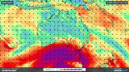
A prolonged period of powerful winds will lash the southern half of Australia from this weekend into next week as a deep low pressure system lingers over the Southern Ocean. A complex and slow-moving low pressure system will pass between Australia and Antarctica over the coming week. This low will send a series of strong […]
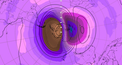
There are signs that another sudden stratospheric warming episode could occur above Antarctica towards the end of August, increasing the likelihood that the Southern Hemisphere’s polar vortex will continue to be disrupted into September. This event could have an ongoing influence on Australia’s weather patterns this spring. What is Sudden Stratospheric Warming? Sudden stratospheric warming […]
Unseasonably high 24-hour rainfall totals have again been recorded to 9 am Wednesday across large parts of southern Queensland and northern NSW, with the heaviest falls in Queensland’s Capricornia, Wide Bay and Burnett, and Southeast Coast forecast districts. The city of Rockhampton recorded 85 mm to 9 am Wednesday, which made it the wettest August […]
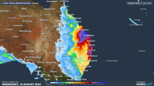
Flood watches have been issued between central Queensland and northeast New South Wales as unseasonably heavy rain continues to drench parts of eastern Australia. A deep layer of moisture-laden east-northeasterly winds interacting with a pair of upper-level low pressure systems is causing widespread rain over eastern Australia. This drenching kicked off on the weekend and […]

Heavy and persistent rainfall is set to impact parts of eastern Qld and northeast NSW from early to mid-next week, as moisture laden easterly winds stream onto the coast. The moist easterly winds will extend up to around 2.5km above the surface, transporting a deep layer of moisture into NSW and Qld. Within this […]

Stretching high above Earth’s North and South Poles are two swirling columns of extremely cold air encircled by powerful winds. These whirlpools of frigid air and wind are each called the polar vortex, and they can have a big influence on weather patterns across the Northern and Southern Hemispheres. What is a polar vortex? A […]

Rain, and plenty of it, has again soaked the southwest corner of Western Australia, with solid falls of around 10 to 30 mm from Geraldton, down through the wheatbelt, all the way to the South Coastal and Great Southern forecast districts. The heaviest falls came with a pronounced rainband that crossed the coastline early on […]
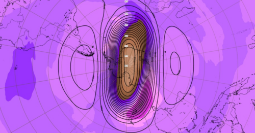
Ongoing stratospheric warming above Antarctica looks set to influence weather patterns across the Southern Hemisphere into August as a strong negative Southern Annular Mode (SAM) takes shape. The atmosphere above East Antarctica started to warm abruptly during the middle of July. This warming initially started in the polar stratosphere, around 30-40km above East Antarctica, but […]

Australia’s tropical cyclone season is officially underway, but we may not see much activity for few months yet. The season runs from November to April, and for mining operators and businesses across northern Australia, 2026-27 is shaping up to be a season where the headline numbers and the real risk may not line up. On […]

A positive Indian Ocean Dipole is underway, but this one is unlikely to deliver the textbook dry spring and summer that businesses have come to expect from the pattern. The Bureau of Meteorology officially declared a positive IOD on Tuesday, October 27, which typically like El Niño can cause drier and warmer conditions over parts of […]

Waters off Indonesia have cooled in recent weeks, an indication that a positive Indian Ocean Dipole (IOD) event could be developing. It’s an important climate driver for Australia, and it could shape rainfall and temperatures heading into summer, with flow-on effects for farmers, energy and other industries. What is the Indian Ocean Dipole? The IOD […]

Leonora, WA, had its wettest September day on record earlier this month. Three weeks later, more than 1.3 million lightning pulses were detected within 800 km of the town in 48 hours. Why is a stalled trough delivering storms to mining country, and what it could mean for operations? The DTN Total Lightning Network detected […]
