

A volatile weather pattern is set to cause widespread thunderstorm activity over Australia throughout the first week of summer, with severe storms likely to hit multiple states and territories. The last week of spring is featuring prolific rain and thunderstorm activity over large areas of northern and eastern Australia. This wet and stormy weather will […]
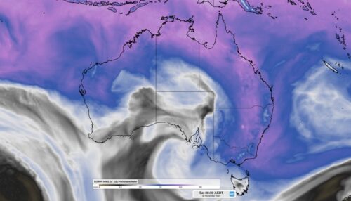
A vast area of northern and eastern Australia is set to see persistent rainfall and thunderstorm activity in coming days, with the potential for flooding in many areas. If you want to understand why, the image at the top of this story explains all. The image shows the amount of “precipitable water” in the atmosphere, […]

An outbreak of dangerous thunderstorms and heavy rainfall will impact parts of eastern Australia in the next two to three days, including the Sydney and Illawarra regions. A low pressure system centred to the southeast of SA and a series of associated troughs have brought heavy rainfall to parts of SA, Vic and southwestern […]

Sydney and other areas in eastern NSW are in the middle of a severe heatwave that’s making the end of spring feel more like the middle of summer. This early-season heat was so intense on Wednesday morning that the Sydney Basin briefly became the hottest place in the world. So, why is it feeling so […]

A relentless five-day run of oppressive heat is impacting NSW, with some towns in the state expected to see the warmest run of November days in 15 years. The prolonged period of heat began on Saturday for western Sydney, with Penrith reaching 35.3°C on Saturday and 37°C on Sunday, with the mercury set to […]
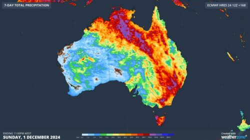
Rain and thunderstorms will hit part of every state and territory in Australia this week, with flash flooding a heightened risk amid the late-spring severe storm outbreak. Several factors will align to cause prolific rain and thunderstorm activity over Australia this week: A hot air mass will linger over northern and eastern Australia, providing some […]

A sustained run of heat will grip Sydney over the coming week, with a string of hot days and uncomfortable nights giving the city an early taste of summer. A blocking high pressure system centred over the Tasman Sea will allow warm northerly component winds to flow over eastern NSW every day between now and […]

A burst of heat will sweep across Australia’s southeastern states during the next six days, causing temperatures to soar in Sydney, Melbourne, Adelaide, Canberra and Hobart. Northerly winds developing ahead of a broad low pressure trough will carry a hot air mass towards southern and southeastern Australia in the coming days. Image: Forecast 850 hPa […]

Oppressive heat is looming for NSW late this week into early next, with the potential to leave NSW with insufficient energy reserves. The Australian Energy Market Operator (AEMO) has sent out several market notices for the lack of reserve forecast on Tuesday, November 26, when heat and humidity is set to peak. AEMO initially sent […]

Australia’s tropical cyclone season is officially underway, but we may not see much activity for few months yet. The season runs from November to April, and for mining operators and businesses across northern Australia, 2026-27 is shaping up to be a season where the headline numbers and the real risk may not line up. On […]

A positive Indian Ocean Dipole is underway, but this one is unlikely to deliver the textbook dry spring and summer that businesses have come to expect from the pattern. The Bureau of Meteorology officially declared a positive IOD on Tuesday, October 27, which typically like El Niño can cause drier and warmer conditions over parts of […]

Waters off Indonesia have cooled in recent weeks, an indication that a positive Indian Ocean Dipole (IOD) event could be developing. It’s an important climate driver for Australia, and it could shape rainfall and temperatures heading into summer, with flow-on effects for farmers, energy and other industries. What is the Indian Ocean Dipole? The IOD […]

Leonora, WA, had its wettest September day on record earlier this month. Three weeks later, more than 1.3 million lightning pulses were detected within 800 km of the town in 48 hours. Why is a stalled trough delivering storms to mining country, and what it could mean for operations? The DTN Total Lightning Network detected […]
