
A volatile weather pattern is set to cause widespread thunderstorm activity over Australia throughout the first week of summer, with severe storms likely to hit multiple states and territories.
The last week of spring is featuring prolific rain and thunderstorm activity over large areas of northern and eastern Australia. This wet and stormy weather will continue on Friday and Saturday, the last two days of spring, with areas of heavy rain expected over parts of the NT, Queensland, NSW, Victoria, Tasmania and the ACT.
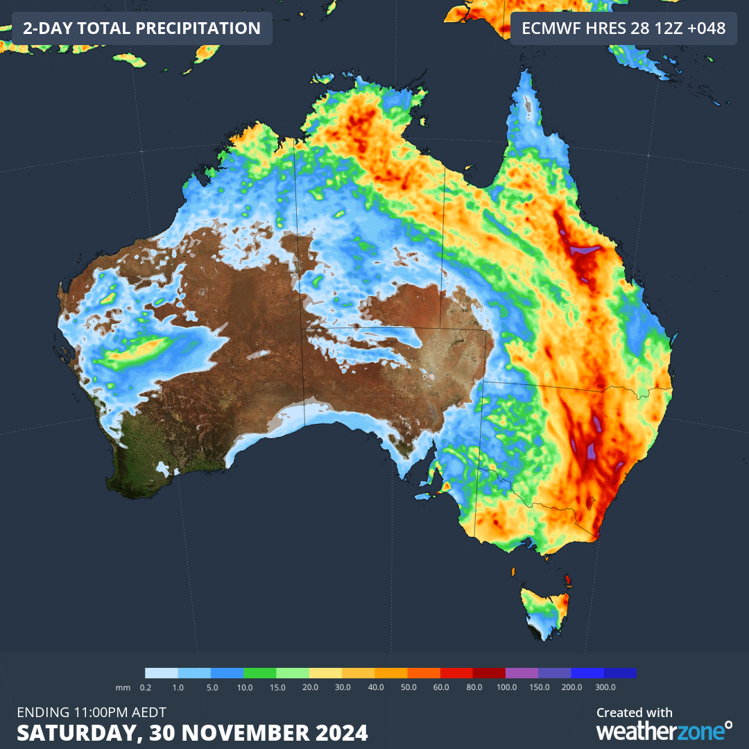
Image: Forecast accumulated rain during the last two days of spring, according to the ECMWF-HRES model.
This end-of-spring soaking will be followed by a new storm-producing weather pattern in the opening days of summer.
An array of surface-based low pressure troughs interacting with a series of upper-level troughs will produce daily showers and thunderstorms over Australia from this Sunday throughout next week.
This stormy start to summer will be enhanced by above average sea surface temperatures to the northwest and southeast of Australia, which will supply ample moisture for storms due to enhanced evaporation.
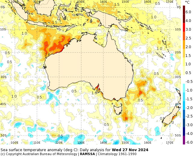
Image: Sea surface temperature anomalies on November 27. Source: Bureau of Meteorology
Rain and storms are likely to develop over part of every Australian state and territory in the first week of summer, with some states to see storms on each of the first seven days of the season.
There is a good chance that some of the impending storms will become severe, produce heavy rain, large hail or damaging winds. It’s also worth pointing out that even if a storm does not meet the criteria to be classified as severe, all thunderstorms produce lightning, which can be dangerous if you are outside during the storm.
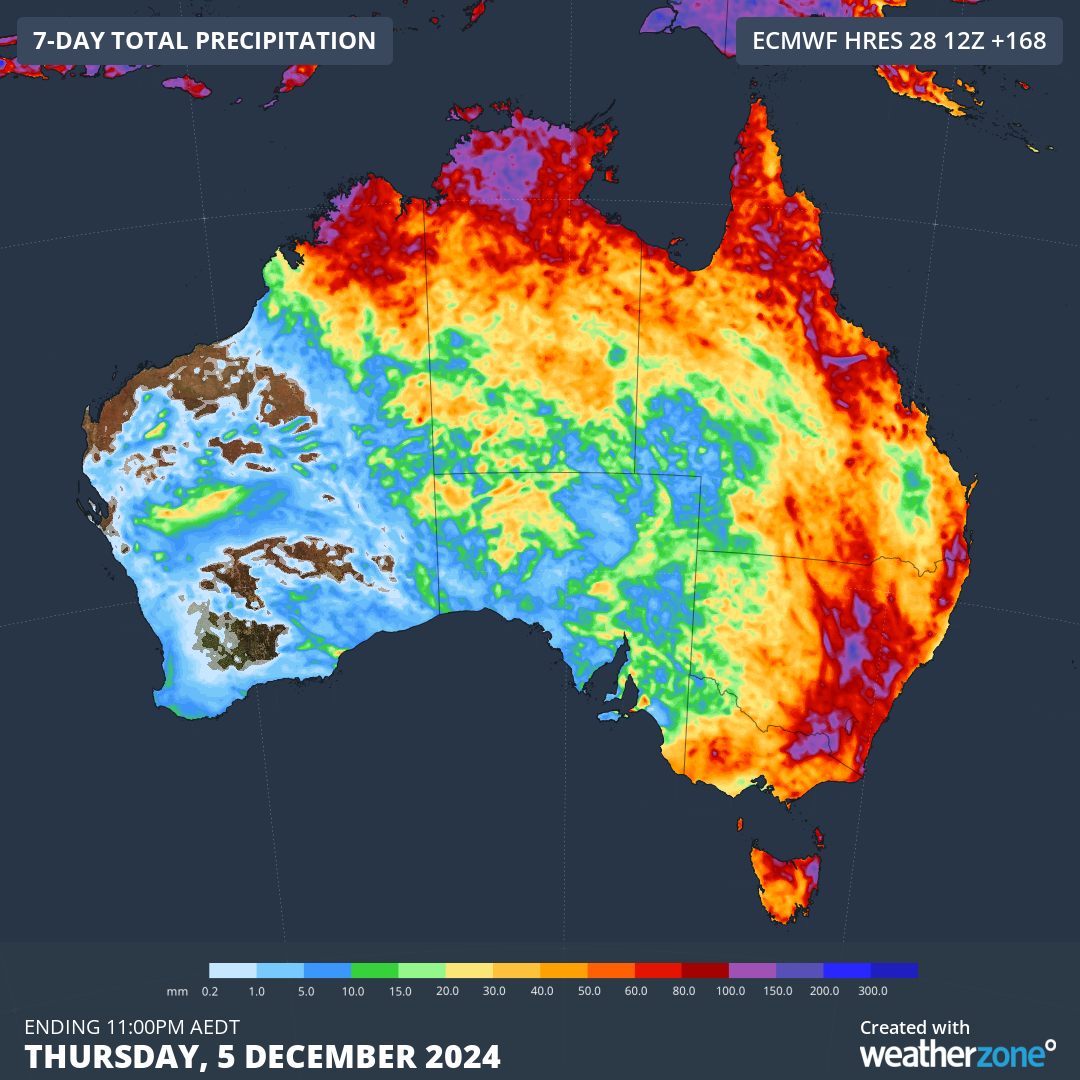
Image: Forecast accumulated rain during the seven days ending on December 5, according to the ECMWF model.
Be sure to check the latest forecasts and warnings in your area for the most up-to-date information during the next two days and throughout the first week of summer.
Stormtracker is a severe weather solution that can assist you in observing, in real-time, any storm or event that has the potential to impact your business.
Embedded in DTN’s industry interfaces, the system gives you a time advantage when monitoring conditions developing over your infrastructure and location.
Stormtracker is our Global Information System (GIS) tracking tool, providing multiple weather layers and zoom controls overlaid on a map of your location and infrastructure. You can choose a snapshot or full screen view, depending on your requirements. The maps allow you to monitor all weather, and specifically any systems likely to cause risk for your business. You also have the capacity to observe:
- real time lightning and thunderstorm alerts
- localised lightning strike frequency
- official warnings for storm, cyclone, wind, flood and fire
- sentinel hotspot fires and fire agency current incidents
Stormtracker’s radar imagery updates every 10 minutes, so you are always able to respond rapidly to changing conditions. You can customise alerting to notify you when your staff or infrastructure are under threat. With increased situational awareness, your ability to make informed decisions quickly is optimised.
DTN’s experience and intelligence gives you a clear path through complex situations. Let us assist you, offering actionable insight when extreme weather poses risk to your business. For more information please visit our website or email us at sales.apac@dtn.com.
Title image credit: iStock / mdesigner125


