Prosper in a dynamic world
Search

Albury’s heaviest rain in 160 years


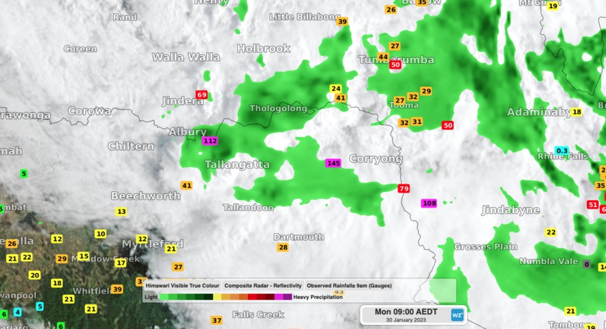
Relentless rain has fallen along parts of the NSW-Vic border during the past 24 hours, with Albury registering its wettest day since 1863.

A near-stationary band of heavy rainfall developed along a convergence line in the Albury-Wodonga region of southern NSW and northeast Vic on Sunday night.

This deluge, which was being fuelled by a mass of unusually humid air, produced an entire summer’s worth of rain in just 24 hours at some locations.

Video: Composite radar, satellite and rainfall observations during the 24 hours ending at 9am on Monday, January 30, 2023.

Albury Airport collected 132 mm during the 24 hours ending at 9am on Monday. This is Albury’s wettest day since 1863 and roughly equal to its long-term seasonal summer average of 135 mm. Some of the most intense rain fell overnight, with 65mm hitting the gauge during the 6 hours ending at 2am on Monday.

Albury has one of Australia’s longest available periods of records for rainfall, with data stretching back to 1858. This past 24 hour’s rain was the 2nd highest daily total in this lengthy period, beaten only by 167.6 mm from April 1 in 1863.

Nearby, the 134 mm of rain that fell at Hume Dam during the 24 hours to 9am on Monday, which was its highest daily total in records dating back to 1922.

Across the border in northeast Vic, Hunters Hill picked up 149.6 mm in the same period, including 48.4 mm in just three hours.

Showers will ease over southern NSW and northern Vic as a low pressure trough moves further north, away from the region.

Latest news

Satisfy your weather obsession with these news headlines from around the nation, and the world.

Madden-Julian Oscillation increasing tropical cyclone potential for northern Australia industries

Sea surface temperatures exceeding 31°C off the coast of northern Australia and an active phase of the Madden-Julian Oscillation (MJO) are increasing the likelihood of early-season tropical cyclone activity, with hints of the season’s first tropical cyclone coming as early as next week. Tropical cyclones require sea surface temperature of 26.5°C or warmer to develop, […]

Tropical cyclone season begins with warm oceans surrounding northern Australia

The 2025-26 tropical cyclone season has begun with abnormally warm oceans surrounding northern Australia, signalling an increased risk for severe tropical cyclones in the coming months. The Australian tropical cyclone season runs from November 1 to April 30. During this six-month period, there are usually about 9 to 10 tropical cyclones in the Australian region, […]

7.8 million lightning pulses detected by DTN’s Total Lightning Network over Australia in one week

A barrage of thunderstorms battered large areas of eastern and northern Australia over the past week, producing close to 8 million lightning pulses across the country and more than 4 million over Queensland alone. DTN’s Total Lightning Network (TLN) detected around 7.79 million lightning pulses above Australia last week. This lightning was observed over every […]

Warmest October on record for Sydney, Brisbane

Sydney and Brisbane just had their warmest October on record, despite a relatively cool end to the month. A surge of cold air caused temperatures to plummet in eastern Australia earlier this week. In Brisbane, the temperature only reached 22.2°C on Tuesday, while Sydney’s maximums remained below 18°C on both Tuesday and Wednesday. These chilly […]