
The southwestern tip of Western Australia is the latest corner of the country to see exceptionally heavy winter rainfall, with 24-hour totals topping 100mm at some locations, and over 250,000 lightning strikes causing costly shutdown procedures.
Storms and heavy downpours pelted much of the South West Land Division on Wednesday as a cold front and associated low pressure system moved in from the Indian Ocean, with the most intense rainfall occurring in the late afternoon and early evening.
Video: Satellite, radar and the Total Lightning Network as seen on the DTN Stormtracker dashboard on the evening of Wednesday, July 2, 2025.
Skies were ablaze as the storms crossed the coastline, with more than 250,000 lightning strikes detected within 500km of Perth.
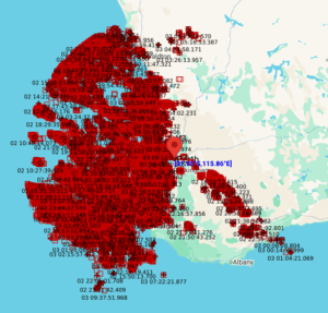
Image: Total Lightning Network detected lightning strikes within 500km of Perth in the 24 hours to 8am AWST on Thursday, July 2, 2025.
Rainfall totals were heaviest near the coast, and especially in the Margaret River region. Notable accumulations to 9am (AWST) included:
- 130mm at the Vasse Highway CB3 weather station just south of Busselton, with falls exceeding 100mm at two other nearby stations.
- 89.2mm at Busselton Airport, the heaviest rain day in any month in almost two years, and the heaviest July fall since the current site opened in 1998.
- 63mm at Bridgetown, the heaviest rain day in any month for four years in the inland town located approximately 100km southeast of Busselton.
- 40.6mm at Mandurah, the heaviest rain day to date in 2025 and the heaviest July rain day since 2019 for WA’s second most populous city.
- 18.8mm at Perth Airport.
The West Australian rain has cleared the far southwest of the state this Thursday morning, with the exception of a few very light showers, however bands of showers continue to dampen parts of the Wheatbelt, north and east of Perth.
Mostly clear skies will set in for a couple of days from this afternoon, before a classic winter pattern returns to the southwest later on Sunday as a strong cold front approaches.
How DTN APAC Total Lightning Network can keep you and your staff safe with Lightning Alerting
Our Total Lightning Network is the intelligent lightning solution that goes above and beyond to alert lightning and increase your lead time before the storm hits.
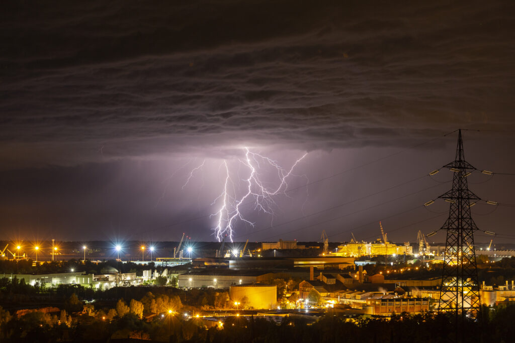
Image: Don’t get caught out by an incoming storm with alerting across your work site. Source: iStock / Jurkos
We utilise a vast global sensor network, created with our partner Earth Networks. Over 1200 sensors in 40+ countries provide a worldwide view of both intra-cloud (IC) and cloud-to-ground (CG) lightning strikes, enabling businesses to plan and respond with the most precise insight available. Our system can detect and calculate strike locations with incredible accuracy, offering real-time lightning mapping for a comprehensive view of storm activity.
Offering unsurpassed accuracy, with real-time sensing to <200m, we integrate with your existing systems to keep your enterprise operating within your defined severe weather thresholds. Our technology also helps monitor radiation from electrical discharges and ensures every lightning flash is accounted for.
The Total Lightning Network can be set up with DTN APAC Onguard Alerting: a scalable visual and audible alarm system that provides simultaneous sitewide alerts to protect your staff and assets when lightning is detected within your thresholds.
Onguard can be customised to your Trigger Action Response Plans (TARPs) and other considerations, ensuring you are securing the safety of your sites based on your existing, functional parameters.
Onguard provides clear, sitewide lightning risk communication for your operations personnel, but also for contractors and visitors who don’t have access to an existing alerting system. The light and sound alerts give everyone on site adequate time to act quickly when thresholds are breached.
With a combination of light beacons and sounders, and a modular, scalable configuration, you can customise the setup to suit any site arrangement and maximise your coverage.
Leave nothing to chance. Be confident working outdoors with the most sophisticated lightning alerting system, delivering intelligence to any device across your business network. Whether you need a personal lightning alerting tool for individual safety or enterprise-wide monitoring, our solution is designed to emit timely alerts and protect your operations.
Learn more about our large range of industry leading products and services or email us at sales.apac@dtn.com


