
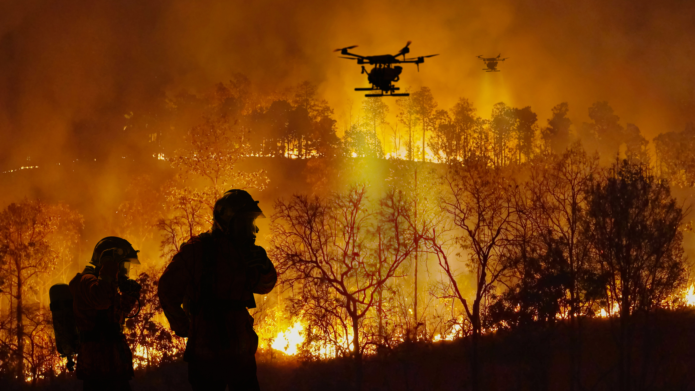
The 2026 El Niño has the potential to become one of the strongest on record, raising the likelihood of a warm and dry spring and summer across much of Australia. With the risk of elevated bushfire conditions later this year, fire and land management agencies are being urged to begin seasonal preparedness early.
Potential record-breaking El Niño
Beneath the surface of the tropical Pacific Ocean, a pool of abnormally warm water has developed in the central and eastern basin. In one region about 50 to 100 m below the equator in the eastern Pacific, the water is more than 5°C above average for this time of year.
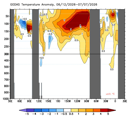
Image: Cross section of water temperature anomalies below the equator, with the Pacific Ocean sitting at the centre of the image between the two inner-most grey bars. The y-axis on the left shows depth in metres. Source: NOAA
This substantial subsurface heat is expected to fuel further warming at the ocean surface over the coming months, allowing El Niño to strengthen through winter into spring. The Bureau of Meteorology’s latest forecasts project the relative Niño 3.4 index to reach around +3.3°C in October 2026, while the latest weekly value (to Sunday, July 12) was +1.47°C.
If that forecast is realised, the 2026 El Niño will surpass the previous Relative-Niño 3.4 record of +2.65°C (based on historical climate reconstructions by BoM) set in November 1902. That historic El Niño coincided with one of Australia’s driest years on record during the Federation drought (1895-1903), with widespread rainfall deficiencies contributing to severe drought across much of the continent. The rainfall map below shows the exceptionally dry conditions experienced across much of Australia during 1902, highlighting the potential consequences of an El Niño of a similar magnitude.
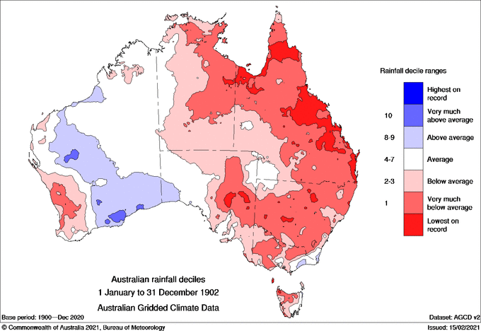
Image: Australian rainfall deciles for 1902. Source: Bureau of Meteorology.
While the 1902 event provides an indication of the potential impacts of an exceptionally strong El Niño, no two El Niño events are identical. Australia’s climate is influenced by several interacting drivers, and the eventual rainfall pattern this year will depend not only on El Niño, but also on the Southern Annular Mode (SAM), the Indian Ocean Dipole (IOD) and regional sea surface temperatures.
Although unusually warm waters surrounding southeastern Australia could provide additional atmospheric moisture for rain-bearing systems, some climate models are also indicating that a positive IOD may develop during late winter and spring. If that occurs, it will reinforce El Niño’s drying influence across southern and eastern Australia, increasing the likelihood of a warm, dry spring. The last time an El Niño and positive IOD collided was in spring 2023 which coincided with Australia’s driest three-month period on record.
A different landscape heading into this fire season
Climate and weather are only part of the bushfire risk equation. The condition of the landscape heading into the fire season, including how much vegetation has grown, how dry it is, and soil moisture, are equally important.
The two satellite images below highlight just how different Australia’s starting point is in 2026 (right image below) compared to the lead-up to the Black Summer in 2019.
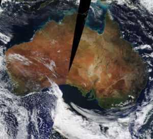
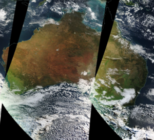
Images: True-colour satellite composites. Left: Australia in mid-July 2019, ahead of Black Summer. Right: Australia in mid-July 2026. Source: NASA Worldview
The contrast is striking. By July 2019 large parts of Australia were already brown, drought-stressed and carrying cured fuels after years of below average rainfall. In 2026 much of central and eastern Australia remains noticeably greener, reflecting healthy vegetation growth supported by above average root soil moisture and a wetter than average June and early July in many regions.
This will lower the fire risk in the coming months in these regions until this abundant vegetation dries out and becomes available fuel as the forecast El Niño and possible positive IOD develop during late winter and spring. If the widespread curing occurs in spring under the influence of warm and dry conditions, the large fuel loads built up over recent years could support significant fire activity, particularly grass fires.
This is why seasonal climate outlooks need to be considered alongside fuel conditions and soil moisture.
“A wet start to the year doesn’t guarantee a quiet fire season. It can increase the amount of vegetation available to burn while delaying curing and the onset of elevated fire danger.”
– Ashleigh Madden, DTN APAC Head Communications Meteorologist
The severity of the season will ultimately depend on how quickly those fuels dry out through spring.
While eastern Australia has remained greener than normal following a wet June and July, the pattern is not consistent across the country. The Bureau of Meteorology’s 6-month rainfall deficiency analysis shows parts of inland northern NSW have slipped into serious to severe rainfall deficiency, with some isolated areas recording the lowest rainfall on record for the period.
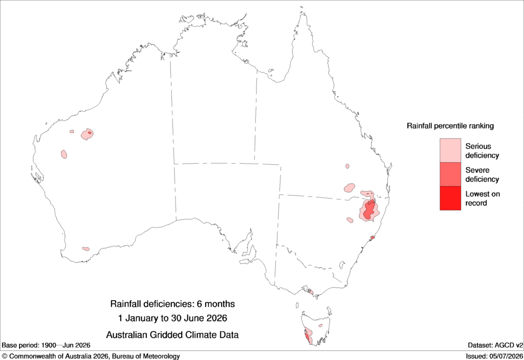
Image: Australian rainfall deficiencies for the six months leading up to June 30, 2026. Source: Bureau of Meteorology
These emerging rainfall deficits are one reason Australasian Fire and Emergency Services Authorities Council (AFAC) identified parts of northern inland NSW as having an elevated fire risk in winter 2026. A similar elevated risk also exists across the northern Great Sandy Desert in WA, where abundant fuel loads left by last wet season are curing and becoming readily available to burn. Together, these regions demonstrate how fire risk depends not only on seasonal climate drivers like El Niño, but also on the local rainfall, vegetation growth and fuel conditions.
Spring 2026 forecast: Prepare for fire risks, don’t wait.
As El Niño strengthens, climate models indicate an increasing likelihood of above-average spring temperatures across much of eastern and southern Australia. The extent of that warming will also depend on other climate drivers, including the Indian Ocean Dipole (IOD), the Southern Annular Mode (SAM) and the background warming trend associated with climate change.
Warmer temperatures, combined with below-average rainfall, would accelerate the curing of the abundant vegetation that has grown across many regions this year, increasing the amount of fuel available to burn. Grasslands can become fire-ready within weeks, while forest fuels dry more gradually as soil moisture is depleted by prolonged warm, dry and occasionally windy conditions.
Historically, El Niño has been associated with more frequent negative Southern Annular Mode (SAM) episodes during spring. When this occurs, cold fronts tend to track further north across southern Australia, with hot, dry and gusty northwesterly winds developing ahead of them. These pre-frontal conditions can rapidly elevate fire danger, combining extreme heat, low humidity and strong winds before the arrival of a cooler southwesterly change.
The result is a landscape capable of supporting fast-moving grass fires and more intense bushfires should an ignition occur. While the timing and severity of curing will vary from region to region, the current climate outlook suggests agencies should be using the coming months to prepare, rather than waiting for the first major fire weather events of spring.
Can’t make it to the Aerial Fire Fighting Asia-Pacific 2026 (AFFAPAC)? Connect with Phil to discuss the upcoming fire season, emerging climate signals, and how weather intelligence can support safer, more informed operational decision-making.

Can’t make it to the Aerial Fire Fighting Asia-Pacific 2026 (AFFAPAC)? Connect with Phil to discuss the upcoming fire season, emerging climate signals, and how weather intelligence can support safer, more informed operational decision-making.
A regional challenge across Asia Pacific
The climate drivers influencing Australia’s fire season are also affecting neighbouring countries across Southeast Asia.
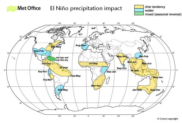
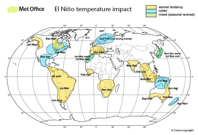
Images: El Niño precipitation (top) and temperature (bottom) impact across the globe, with yellow showing drier and warmer conditions and blue showing wetter and colder. Source: UK Met Office.
The images above show parts of the Philippines and Thailand likely to experience a drier-than-average second half of the year as El Niño strengthens, increasing pressure on water resources, agriculture and bushfire management. Should a positive Indian Ocean Dipole also develop during spring, it could reinforce drying across parts of maritime Southeast Asia and Australia.
For New Zealand, the influence of El Niño differs from the impacts typically experienced across Australia and Southeast Asia. Rather than driving widespread heat and dryness, El Niño often shifts the circulation pattern towards stronger and more frequent westerly winds, increasing the passage of frontal systems across the country. These systems can bring periods of cooler, unsettled weather, particularly as colder air masses move north from the Southern Ocean.
However, the enhanced westerly flow can also increase drying risks on the eastern side of the Southern Alps and other mountain ranges. As air descends on the leeward side, föhn winds can develop, warming and drying rapidly as they move into the rain-shadow regions. This can reduce soil moisture, dry vegetation and elevate fire danger, particularly across eastern and northern parts of the country, including areas of Canterbury, Otago, Hawke’s Bay and Wairarapa.
Another source of uncertainty later in the year will be the evolution of the Southern Hemisphere stratospheric polar vortex. While relatively uncommon in the Southern Hemisphere (despite it occurring during 2024 and 2025), a sudden stratospheric warming (SSW) event can disrupt the polar vortex and influence surface weather patterns for several weeks. If such an event were to occur and propagate through the atmosphere, it would alter the Southern Annular Mode (SAM), potentially increasing the frequency and amplitude of dry, windy conditions across parts of eastern Australia and eastern New Zealand, depending on the timing and evolution of the event.
For organisations operating across multiple jurisdictions, consistent weather intelligence becomes increasingly important. DTN APAC provides regional forecasting expertise across Australia, New Zealand and Southeast Asia, helping organisations manage weather-related risks using a single, trusted source of operational intelligence.
Why early weather intelligence matters
While the official AFAC Seasonal Bushfire Outlook for spring 2026 is expected to be released in late August, the emerging climate signals are already providing agencies with valuable lead time. Seasonal outlooks are not designed to predict the exact timing or location of fires, but they do provide early guidance on how the season is likely to evolve.
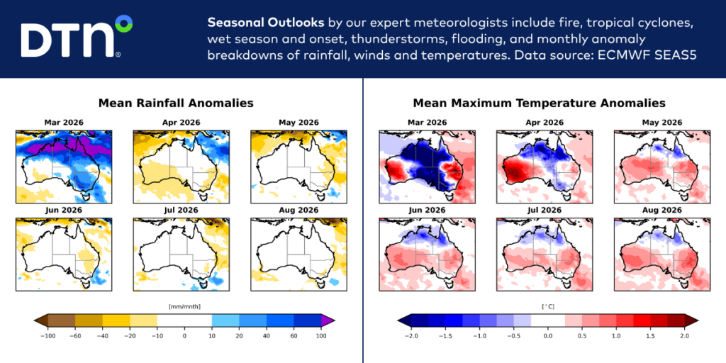
Image: Sample Mean Rainfall Anomalies and Mean Maximum Temperature Anomalies from March 2026 to August 2026. Source: ECMWF SEAS5
For fire, forestry and land management agencies, this additional lead time supports decisions well before conditions begin to deteriorate. It allows organisations to:
- Review resource availability;
- Plan aircraft and crew deployment;
- Identify hazard reduction opportunities;
- Schedule equipment maintenance; and
- Strengthen community preparedness ahead of the peak fire season.
Seasonal outlooks become even more valuable when combined with shorter-range weather forecasts and real-time observations. A seasonal outlook can identify regions where fire potential is increasing months in advance, while daily forecasts, lightning detection and severe weather monitoring provide the operational intelligence needed to make decisions on the day.
Turning seasonal risk into operational readiness
Preparing for bushfire season requires weather intelligence across multiple time scales from understanding how the season is likely to develop months in advance to monitoring rapidly changing conditions on the fireground.
DTN APAC supports forestry, emergency management and fire agencies throughout the prevention, preparedness, response and recovery cycle (PPRR) by combining seasonal climate expertise with industry-leading weather intelligence.
WeatherGuard®
WeatherGuard delivers location-based severe weather and lightning alerts directly to field crews, alongside radar, GIS mapping and custom alert thresholds that integrate with existing operational procedures. Learn more
Total Lightning Network (TLN)
Lightning is one of Australia’s leading causes of natural bushfire ignitions. Total Lightning Network detects both cloud-to-ground and intra-cloud lightning to within approximately 200 metres, helping you protect your people, and operations outdoors. Learn more
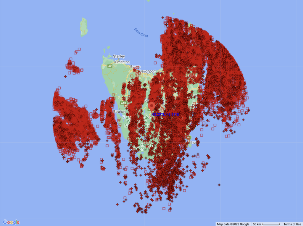
Image: Lightning detected by DTN APAC Total Lightning Network (TLN) during a thunderstorm outbreak in Tasmania in late October 2023. There were 35,055 strikes detected within a 300 km radius during this event, with 15,451 of these being cloud-to-ground strikes.
Seasonal outlooks and 14-day forecasting
DTN APAC outlooks and forecasting help agencies anticipate changing fire weather patterns, identify periods of elevated risk and support strategic planning before the season peaks.
Together, these capabilities provide agencies with a common operating picture, from seasonal planning and hazard reduction scheduling through to real-time operational decision-making and post-event analysis.
Learn about how DTN APAC supports the Forestry & Emergency sectors or get in touch with our team of experts today at sales.apac@dtn.com
Image thumbnail: iStock / Toa55




