
Two key measures scientists use to track El Niño broke records in July 2026, indicating that a record-breaking event is underway with real implications for Australian businesses this spring and summer.
The Bureau of Meteorology officially declared El Niño in mid-June 2026, with modelling at the time already indicating that this could be one of the strongest events on record.
A record pool of heat building beneath the surface
El Niño brings unusually warm water to the central and eastern tropical Pacific, shifting rain-bearing rising air away from Australia and toward the middle of the Pacific Ocean.
The chart below is a cross-section of the equatorial Pacific Ocean, showing sub-surface waters more than 5°C (up to about 9°C) warmer than average in the central and eastern Pacific.
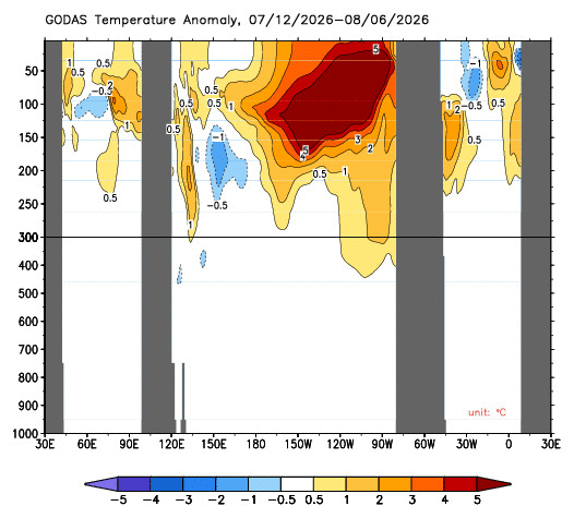
Image: GODAS subsurface temperature anomaly for the month leading up to August 08, 2026. Source: Bureau of Meteorology
According to the Bureau of Meteorology, the amount of heat sitting in this subsurface pool during July 2026 was the highest of any month on record since 1979. This record subsurface heat will provide fuel for this El Niño event, with weakening trade winds bringing the warm water to the surface and sustaining the event.
Record negative pressure difference between Darwin and Tahiti
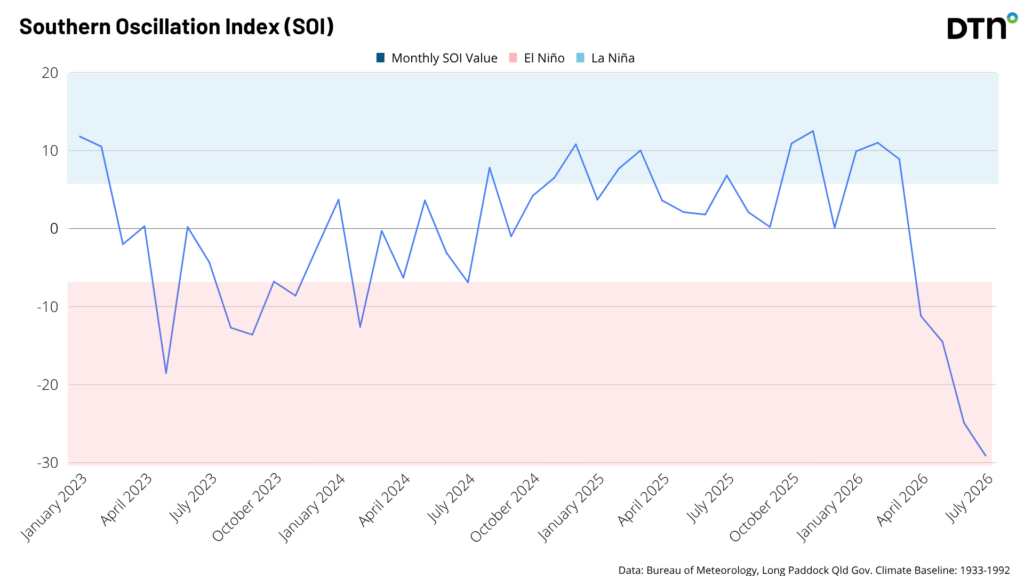
It’s not just the ocean that broke records in July- the atmosphere over the Pacific Ocean is showing an equally strong signal. The rising air over the central eastern Pacific during an El Nino typically causes low pressure anomalies in that region while sinking air over northern Australia causes high pressure anomalies. That pressure imbalance is exactly what a negative Southern Oscillation Index (SOI) measures. For El Niño, the values must be sustained below –7, and the more negative the number the stronger the atmospheric signal.
In July 2026, the SOI averaged -29.1 which was the most negative value on record for July. To put that in context, the July value is roughly four times more negative than the threshold usually used to declare when El Niño is underway.
Does a more extreme SOI mean larger impacts?
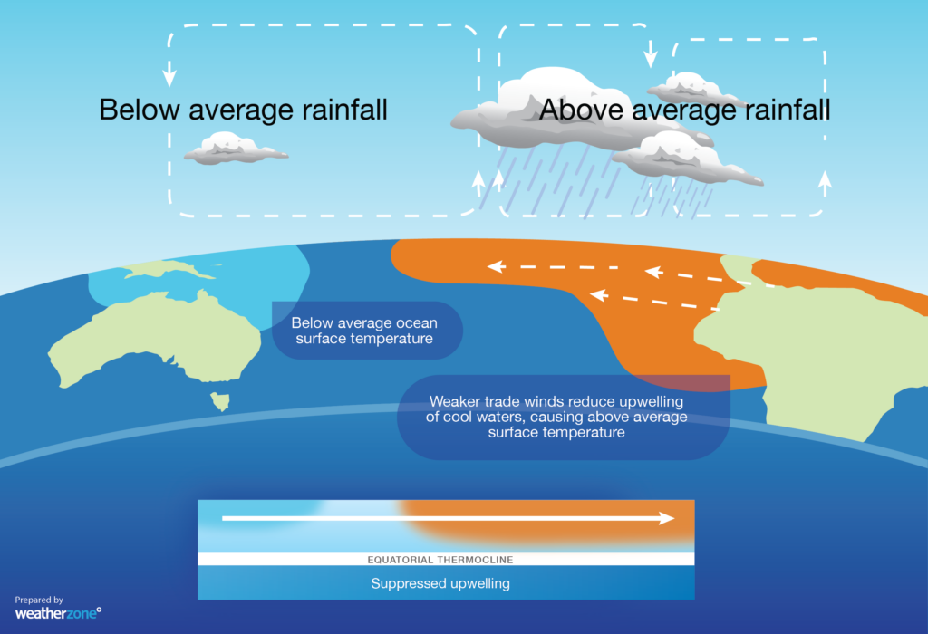
While a strongly negative SOI can increase the impacts we see in Australia, it doesn’t always mean proportionally more severe impacts. The more negative the SOI, the weaker the trade winds, creating a self-sustaining circuit that firmly establishes the El Niño pattern in the atmosphere. The infographic below shows the impact of El Niño and the circulation in the atmosphere, with sinking air near Australia.
The more extremely negative SOI readings do tend to raise the odds of the classic El Niño impacts in Australia: hotter days, less rain, and higher fire risk. However, El Niño is also only one piece of the climate puzzle, with the Southern Annular Mode (SAM), various tropical waves, unusually warm sea surface temperatures and the Indian Ocean Dipole (IOD) all set to play a part in the weather we experience here in Australia this spring and summer.
Why a strongly negative SOI matters for Australia
A deeply negative SOI reflects a weakening or reversal of the normal trade winds that blow warm, moist air toward northern Australia and Indonesia. This suppresses monsoon activity, with less moisture available to fuel rain-bearing systems across the country.
Historically, this pattern tends to bring:
- Below-average rainfall, particularly across eastern and northern Australia
- Above-average daytime temperatures, thanks to reduced cloud cover
- Elevated bushfire risk heading into spring and summer, as vegetation dries out
- Reduced river flows and water availability, especially in the Murray-Darling Basin
None of these outcomes are guaranteed for any single location, especially with unusually warm sea surface temperatures surrounding Australia which will likely provide more moisture to fuel rain and storms this year than a typical El Niño summer and could also increase humidity.
The maps below show observed summer rainfall deciles during the two most recent El Niño events. They show that, despite El Niño, rainfall was above-average over large areas of Australia. This wet summer signal was caused by the influence of other climate drivers and warmer-than-average sea surface temperatures near Australia. It’s also worth noting that while the 2026-27 El Niño is expected to peak during summer, the strongest link to rainfall is typically during spring.
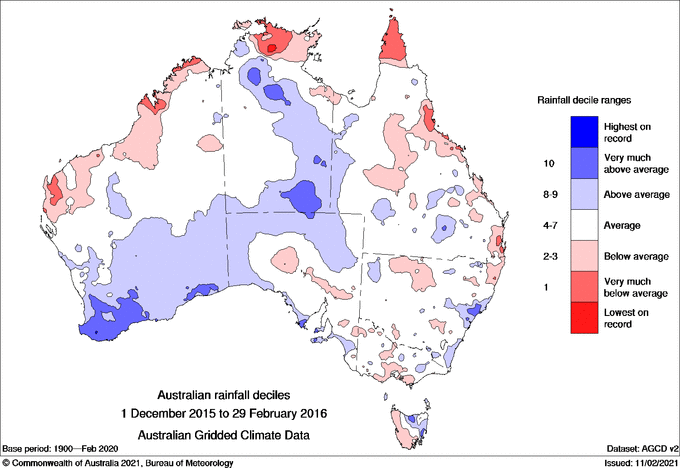
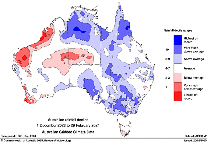
Images: Australian rainfall deciles during the 2015/16 (left) and 2023/24 (right) summers. Source: Bureau of Meteorology.
How strong is this El Niño
The latest weekly relative Niño3.4 index reading was +2.20°C for the week ending on August 08, comfortably past the threshold used to define a very strong El Niño above +2.0°C.
With record subsurface heat still available to feed this El Niño event, and the atmosphere already responding at record strength, most model guidance expects further strengthening into spring, with a peak likely between November and January.
According to data on the Bureau of Meteorology’s website, the highest monthly relative Niño 3.4 value in records dating back to 1900 was +2.65°C (reconstructed for relative index) in November 1902. The European model (ECMWF) currently forecasts the relative Niño3.4 index to reach +3.6°C in November this year, which would obliterate the old record by around 1°C. The ECMWF model also suggests a rapid weakening of El Niño during autumn 2027, with many ensemble members below the +0.8°C threshold by June 2027
What it means for businesses and key industries
A record-strength El Niño has direct, practical implications for several major sectors of the Australian economy.
Mining and resources
Drier conditions and elevated heat across inland Australia can affect operations in multiple ways:
- Increased dust generation and heat-stress management on open-cut sites
- Greater fire risk to infrastructure and access roads
- In some regions, water availability constraints for processing
Sites in northern Australia may also need to reassess wet-season contingency planning, given the typically suppressed monsoon activity associated with El Niño, along with reduced tropical cyclone numbers.
Energy
El Niño’s influence on the energy sector is a mixed picture. Reduced cloud cover can boost solar generation in northern and eastern regions, but wind generation across southern states including Victoria, NSW and SA tends to run below average, as high-pressure systems become more persistent and cold fronts are pushed further south. On the demand side, extended heatwaves increase electricity demand for cooling, adding pressure to the grid on already-constrained wind drought days. Energy businesses and grid operators typically factor these compounding risks into their seasonal planning. This year the warm sea surface temperatures could increase the humidity typically seen during El Niño years, and onshore winds can cause showers and reduced solar output at times.
Agriculture
Below-average rainfall and reduced river flows, particularly in the Murray-Darling Basin can affect irrigation availability, pasture growth, and crop yield expectations across cropping and grazing regions. Producers in traditionally rain-reliant areas are often the most exposed to a strong, sustained El Niño signal like this one.
Fire and emergency services
Drier fuel loads combined with above-average temperatures typically bring an earlier and more intense start to the fire season. Although, this year, a wet autumn and winter has led to vast vegetation growth and elevated soil moisture across parts of Australia. The vegetation, once dry, could bring an increased risk of fire this spring and summer, particularly grass fires. Fire and emergency services agencies generally use strong El Niño signals like this one to inform earlier resourcing, hazard-reduction burn scheduling, and public awareness campaigns well ahead of the traditional bushfire season.
Insurance and risk management
Elevated fire, heat, and drought risk can flow through to higher claims exposure in affected regions, and businesses with weather-sensitive operations often use seasonal outlooks like this one to review risk mitigation and business continuity plans before the higher-risk months arrive. The good news for insurance is that El Niño typically reduces cyclone and severe tropical cyclone numbers, with less moisture and cooler waters to the north of Australia.
The common thread across all these sectors is the same one that applies to households: a strong El Niño doesn’t guarantee a specific outcome for any single business or region, but it does shift the odds, and with records already falling in July, the case for proactive planning this year is stronger than usual.
Thumbnail Credit:Thurtell




