
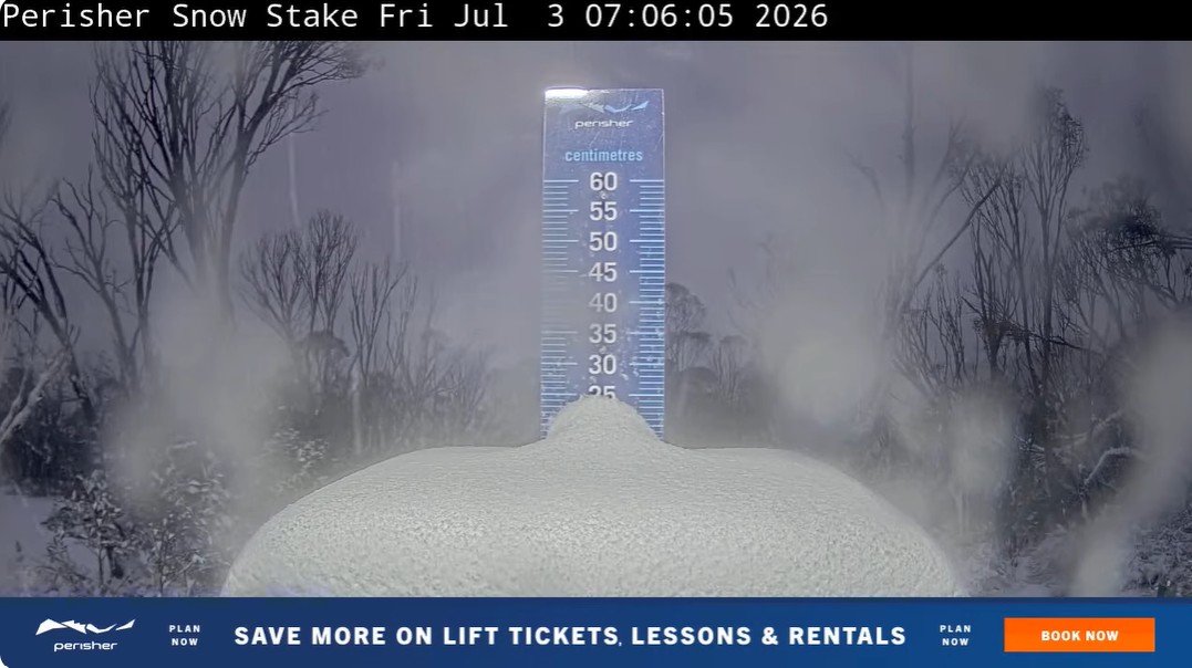
For most of June, the Snowy Mountains looked like they’d skipped winter altogether. Now, 28 cm of fresh snow has fallen at Thredbo, providing a promising sign for the season’s eventual snowmelt contribution to hydropower.
Thredbo in New South Wales was reporting 28 centimetres of snow overnight with snowfalls continuing this Friday morning, its nearby neighbour Perisher reported 25 cm, while Mt Hotham in Victoria reported 22 cm and counting.
The best snowfall so far this season comes as a series of low pressure fronts and troughs pass over the southeast of Australia. These systems also led to a NEM-wide wind generation record of 10,349 MW, reached during the 21:20 dispatch interval on Wednesday, July 1.
Video: Himawari satellite imagery for 3 hours leading up to 12:50pm on Friday, July 3, 2026. Source: DTN.
The recent snowfall has come not long after the best week of hydropower in a year for NSW, with the state producing 111 GWh/week between June 22 and 28. However, that week was relatively dry with less than 5 mm falling in the catchment.
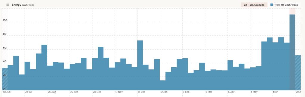
Image: NSW hydropower generation during the past year. Source: OpenNEM
The strongest week in a year was likely supported by releases from existing healthy storage rather than new inflows.
Despite the slow start to the season, lake levels across the Snowy catchment entered winter in good shape, providing a solid buffer despite the lack of snow.
The image below shows that the levels at Lake Eucumbene are higher in 2026 than they were at the same time in 2025. This shows that Snowy Hydro has healthy lake levels which can support water releases and hydro production like we saw last week, without relying on snow and runoff.
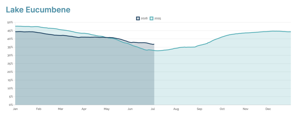
Image: 2026 vs 2025 lake levels at Lake Eucumbene. Source: Snowy Hydro
While reservoir levels across the Snowy scheme remained healthy, the alpine snowpack told a very different story. Spencers Creek, at 1,830 m above sea level in the high country south of Eucumbene, recorded virtually no persistent snow cover through late June – well below the same time in 2025.
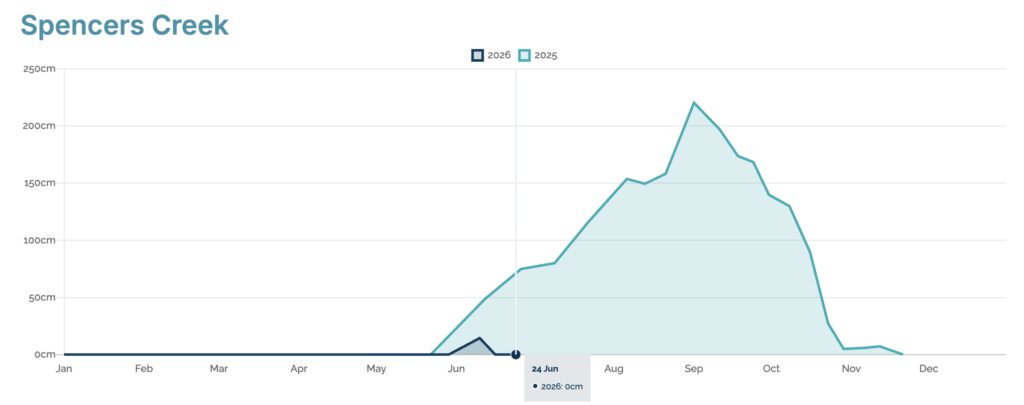
Image: 2026 vs 2025 snow level at Spencers Creek. Source: Snowy Hydro
The lack of snow cover across the alps, comes as The Bureau’s national summary for June released early this month stated Australia’s area-average mean was 1.5°C above the long-term average-the fifth warmest since national records began in 1910. NSW specifically had its third-warmest June on record for maximum temperature and second warmest for both minimum and mean temperatures.
The month was not cold enough to produce decent snowfalls even when rain-bearing systems moved over the mountains. While June 2026 was 27% wetter than average nationally (the wettest June since 2016), the Snowy catchment shows a mixed picture for June with western areas receiving above average rainfall while the east and coastal areas remained dry.
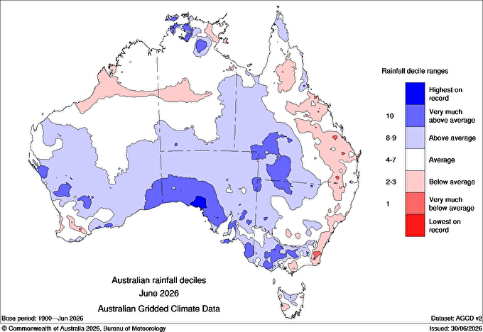
Image: Australian rainfall deciles for June 2026. Source: Bureau of Meteorology
The lack of substantial snowfall in the region has also been linked to the Southern Annular Mode (SAM) – a measure of how far the belt of Southern Ocean westerly winds has shifted from its normal position – reached a near-record +5.06 in late June, among the strongest readings since comparable records began.
A strongly positive SAM pushes cold fronts further south toward Antarctica and strengthens moisture-laden easterly flow into eastern Australia instead, meaning systems crossing the southeast delivered plenty of rain, but not the cold needed to turn it into snow over the Alps.
Looking ahead: El Niño
El Niño years in Australia are generally warmer and drier through winter and spring, conditions that work directly against snowpack – less precipitation to begin with, and what does fall is more likely to arrive as rain rather than snow or melt faster once it’s on the ground.
According to peer-reviewed research published by CSIRO analysing the Spencers Creek record back to 1954, average peak snow depth runs around 23% lower during El Niño years than in neutral years.
Read more: El Niño is here – What a Potential Record Event Means for Southeast Asia and Australia
What does this mean for the season ahead?
Most likely, the snowy scheme should see a smaller spring top-up. In a normal year, the melting snowpack sends a second pulse of water into Eucumbene and Jindabyne through spring, on top of whatever rain falls – it smooths out the Scheme’s supply across the year.
Spencers Creek only just started building again after sitting at zero through June, so that pulse is likely to be smaller than usual this year, even with this week’s snow. This means the Scheme may be leaning more on stored water and rainfall through spring and summer than the usual snowmelt boost.
DTN APAC helps energy businesses translate weather into operational decisions
From snowfall and catchment inflows to hydro generation, renewable output and electricity demand, DTN APAC meteorologists and intelligence provide the actionable support needed to stay ahead of changing conditions. Learn more about our solutions for Energy and Renewables.
Thumbnail: A healthy total on the Perisher snowstake as dawn breaks on Friday, July 3, 2026. Source: Perisher.




