India’s 2026 southwest monsoon delivered the fifth-driest June since records began in 1901 – with Jharkhand’s Chandan Dam, in the heart of the central mining belt, recording zero storage according to the Central Water Commission.
The monsoon arrived three days late to Kerala on Thursday, June 4, 2026, before pausing roughly over the Karnataka/Goa/Maharashtra border area in early-to-mid June, and not pushing north again until June 23, when it reached Mumbai and parts of Telangana and Odisha. The pause meant that parts of northern India were left waiting even longer for the monsoon and its drenching rainfall.
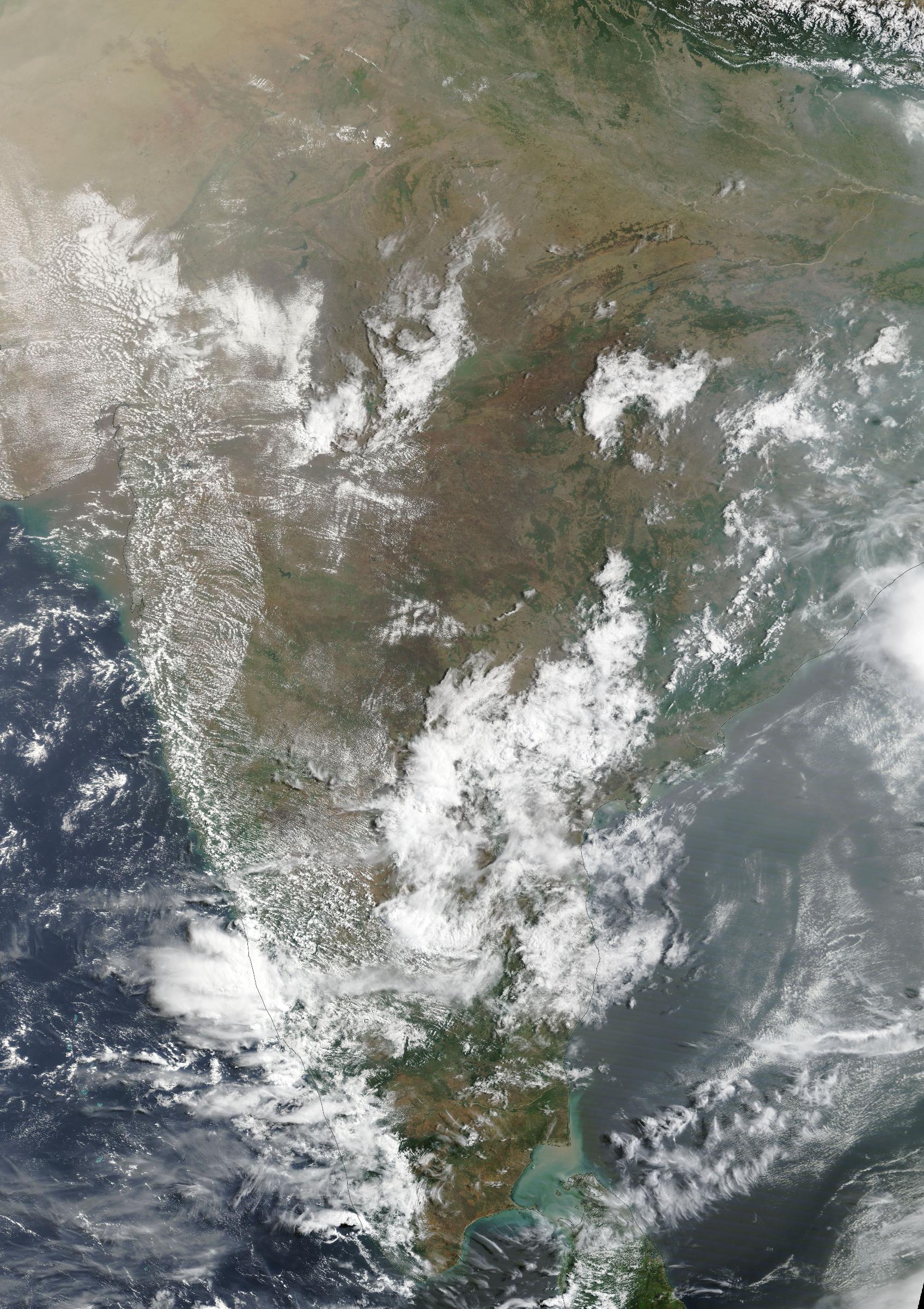
The satellite imagery below shows the monsoon arriving in Kerala in the opening days of June, depicted by cloud cover advancing from south to north- before stalling over the Karnataka/Goa/Maharashtra border area through mid-June. The absence of cloud cover over central and northern India during this period is clearly visible, leaving the country’s major mining belt and agricultural regions without rainfall during a critical period, before the monsoon pushed north again from June 23.
Images: Satellite imagery, June 1–30, 2026. The absence of cloud cover over central and northern India during the monsoon pause (mid-June) is clearly visible, with the revival beginning from June 23. Black strips are data gaps from the MODIS satellite’s orbital path. Source: NASA Worldview
According to the Indian Meteorological Department (IMD), India recorded 99.5 mm of rainfall in June compared to the long-term average of 165.3 mm, making June the fifth driest since records began in 1901 and the worst start to the monsoon in more than a decade.
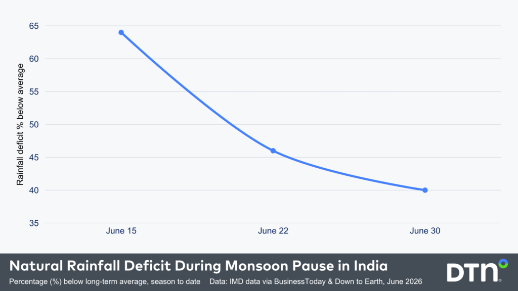
The IMD also reported that India recorded only 19.2 mm of rainfall compared to the normal of 53.7 mm between June 4 and June 15, a nationwide rainfall deficit of 64%. As shown in the graph below, the rainfall deficit recovered slightly by the end of June, as moisture-laden air from the Arabian Sea pushed further inland, narrowing the nationwide deficit from 64% to 40%.
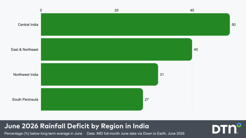
The rainfall deficit in June wasn’t spread evenly across the country, with central India recording the largest deficit across the country’s mining belt at 50% below normal, followed closely by the East and Northeast with 40% and the Northwest with 31%. While the monsoon arrived in the south first, it still underdelivered, with the South Peninsula recording a 27% deficit.
El Niño: The Main Driver Behind the Deficit
El Niño was officially declared in June 2026, raising the prospect of widespread impacts across Southeast Asia, from extreme heat and water shortages to higher energy demand and agricultural stress.
El Niño is one of three phases of the El Niño-Southern Oscillation (ENSO) – a global ocean and atmosphere phenomenon originating in the tropical Pacific. El Niño occurs when sea surface temperatures in the central and eastern tropical Pacific become warmer than average and trade winds blowing across the tropical Pacific weaken or reverse.
These changes cause cloud and rainfall to become suppressed in the western Pacific and enhanced over the central and eastern Pacific. For India, El Niño typically reduces rainfall over much of the continent with a late and weaker monsoon. The circulation that draws moisture across the continent becomes less favourable, suppressing rainfall particularly over central and peninsular India.
El Niño was one piece of the climate puzzle in June, with the Madden-Julian Oscillation (MJO) also in an unfavourable phase near the equator, suppressing convection across India and further reducing rainfall across the country.
Current forecasts indicate that this El Niño will continue to strengthen through the second half of 2026 and should persist into early 2027. This event is expected to become strong or very strong, with Australia’s Bureau of Meteorology pointing out that “around half of the models indicate this event could peak at levels among the highest observed since 1950.” This means that the 2026 El Niño will shape this monsoon season and potentially beyond.
The chart below plots July–September rainfall anomalies across the Central Indian mining belt – the mineral-rich states of Jharkhand, Chhattisgarh, Odisha and Madhya Pradesh – against more than eight decades of records
The red bars show years of below-normal rainfall, the blue bars above-normal. The pattern is striking: nearly every strong El Niño year sits deep in the red, with the 1972, 1982 and 2015 events each producing deficits of more than 200 mm below normal.
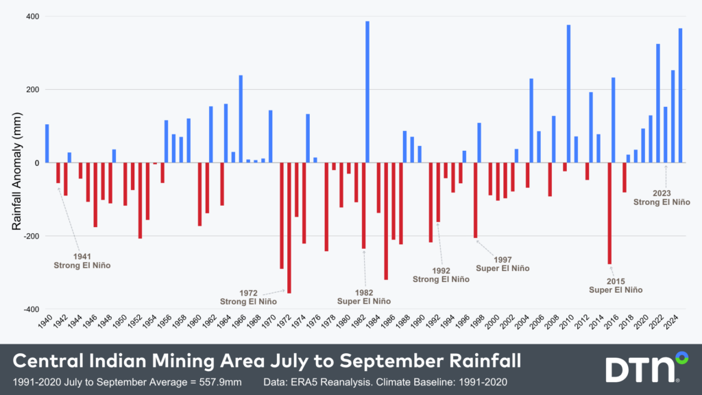
It is worth noting that no two El Niño events are the same. The strong event in 2023 delivered above-average rainfall across much of India, largely because a strong positive Indian Ocean Dipole (IOD) developed simultaneously and offset El Niño’s suppressing effect
The IOD adds a layer of complexity to the outlook. The IMD is forecasting a neutral IOD; however, some climate models suggest a positive IOD could develop towards the end of the season. A positive IOD normally acts as a wet influence on India’s climate, contradicting El Niño’s drying effect. However, for 2026, the El Niño signal is assessed as the dominant driver, with any positive IOD influence likely arriving too late to change the seasonal rainfall outlook at this stage.
Mining Operations in India
Central India’s mining belt, known for coal, iron ore and manganese, is largely located in the area that has seen a 50% rainfall deficit during June 2026. The chart above shows that during most strong El Niño events, this region can see July-September rainfall deficits of more than 200mm.
The suppressed and delayed monsoon typically:
- Reduces flood-related disruptions and access delays;
- Causes haul roads to remain open;
- Decreases equipment downtime from waterlogging decreases;
- Amplifies heat stress for workers and machinery;
- Increases dust levels;
- Decreases water availability, which is needed for dust suppression, ore processing and equipment cooling; and
- Creates occupational health risk.
As of June 25, India’s 166 major reservoirs held just 26% of their total storage capacity according to the Central Water Commission – down from 28% at mid-month. Jharkhand’s Chandan Dam and reservoirs across the central mining states recorded near-zero levels, directly tightening the water supply that mines depend on for dust suppression, ore processing and equipment cooling.
Learn more about our Mining solutions
Port Operations in India
For India’s west coast ports, the delayed monsoon has provided an unexpected operational reprieve: the southwesterly swell that typically disrupts berthing, barge movement and anchorage operations on the west and south coasts has also been pushed back.
But the window of calmer conditions comes with a catch: when the swell does arrive, it is likely to be compressed into a shorter, less predictable period, making vessel scheduling and cargo planning harder to manage than in a normal monsoon year.
According to a monsoon preparedness circular issued by Jawaharlal Nehru Port Authority, Mumbai’s Indira Dock has already implemented storm gate restrictions, draft limits and cold move bans through September 15 – a reminder that the difficult part of the season is still ahead.
Learn more about our Port & Marine solutions
Energy Industry in India
The monsoon deficit creates a compounding energy problem. Reservoirs across central and peninsular India are filling more slowly than normal, constraining hydropower generation at a time when electricity demand remains high during the pre-monsoon heat and humidity. To compensate, India must rely more heavily on coal-fired thermal power, which was reportedly already under pressure prior to the monsoon season, compounding the effect on the energy sector.
Learn more about our Energy solutions
Agriculture in India
Beyond energy, a delayed monsoon increases uncertainty across reservoir storage, water allocation, and flood risk management. In agriculture, 24 of 36 meteorological subdivisions recorded deficient rainfall in June, increasing irrigation demand and stressing crop supply chains.
DTN APAC supports major industries through seasonal changes in tropical cyclones and monsoon activity
Our global team of experts combined with industry-leading weather intelligence support operational teams across major industries. From site-level operational forecasting for mining operators across central India, to real-time marine and swell forecasting for port authorities on India’s west coast, and integrated seasonal outlooks for water and reservoir managers, discover our solutions and services today including dedicated Risk Communicators, tailored Seasonal Outlooks, and more. Get in touch with our team at sales.apac@dtn.com


