
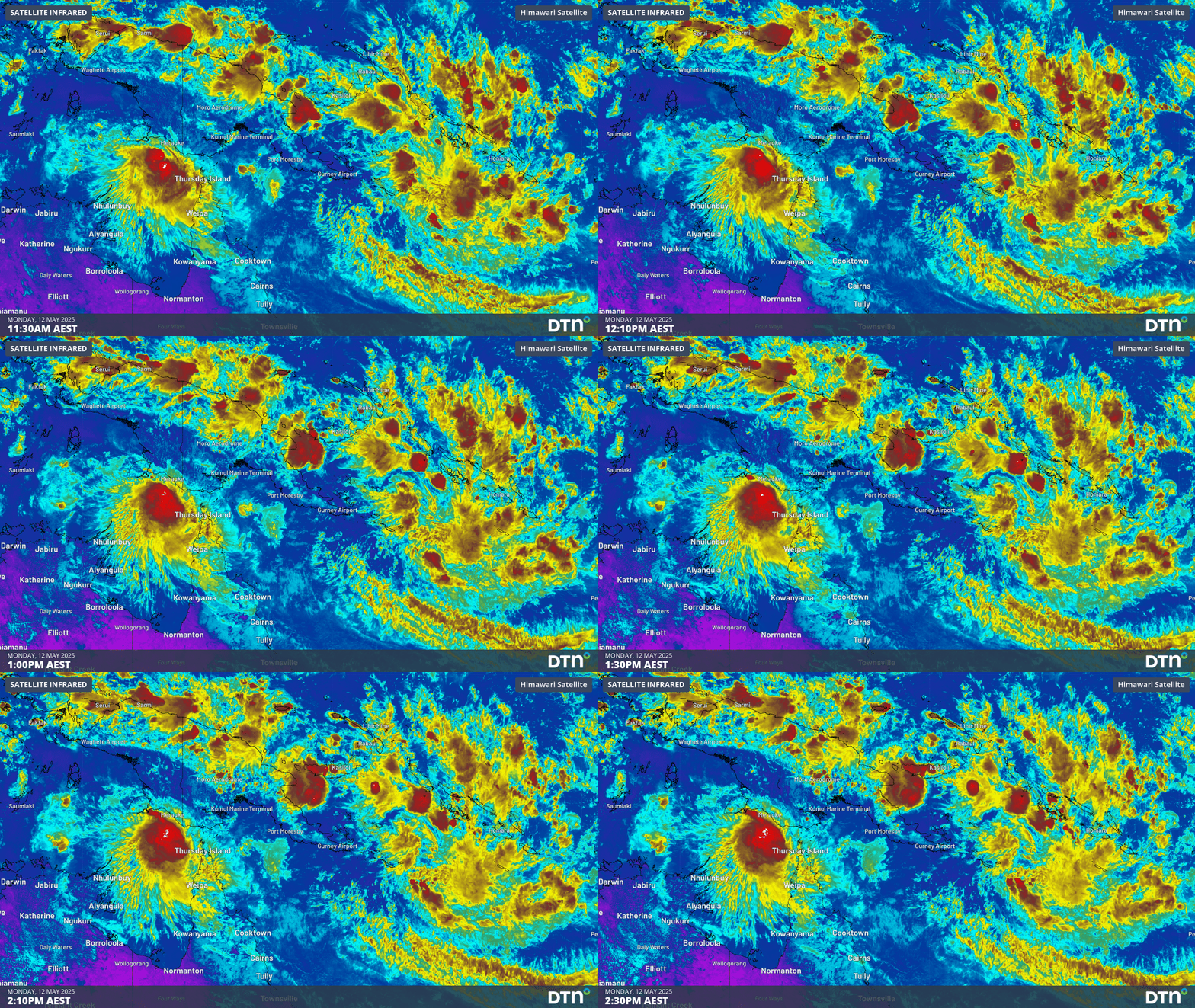
Tropical lows, monsoonal winds, heavy rainfall and earthquakes are affecting areas around Australia, bringing weather much more typical to the wet season.
Tropical Lows 33U and 34U
Tropical lows and cyclones can form at any time of year but become much less frequent over the Australian region during the Southern Hemisphere winter. This is due to the northward expansion of the subtropical ridge and cooler sea surface temperatures.
The map below shows two areas of low pressure being monitored for tropical cyclone intensification.
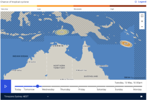
Image: Chances of tropical cyclone development of Tropical Lows 33U and 34U on Tuesday, May 13. Source: BoM
Tropical Low 33U has a very small chance of developing into a tropical cyclone today (Monday, May 12) or tomorrow over the northern Arafura Sea, near West Papua. Movement over a less favourable atmospheric environment from tomorrow will cause the system to weaken. Impacts over the Australian mainland are unlikely, however southern parts of West Papua can expect periods of heavy rain to start off the week.
Image: Satellite loop showing Tropical Lows 33U and 34U over the northern Arafura Sea, and Solomon Sea, respectively, on Monday, May 12.
Tropical Low 34U is located in the Solomon Sea and will have the greatest chances (about 25%) of developing into a tropical cyclone around Wednesday, May 14. The system is expected to take a slow-moving track towards the southeast, with direct impacts unlikely for the Australian mainland. Parts of the Solomon Islands can expect a very wet week as moisture streams into the low, with the heaviest falls coming for the rest of Monday and into Tuesday.
Trade winds missing from northern and central Indonesia
The northward progression of the southeasterly trade winds over Indonesia marks the return of the dry season. Frequent and heavy rainfall and thunderstorms throughout the wet season cause transport disruptions through flooding and rainfall, so the switch from westerly to easterly winds brings more predictable and settled days.
This year, the moist westerly winds are still being experienced well into May as far south as western parts of the Indonesian island of Java, on which the capital of Jakarta is located. As seen in the image below, easterly trade winds have moved over eastern parts of Java and Bali, but moist westerlies remain across Sumatra and western Java.
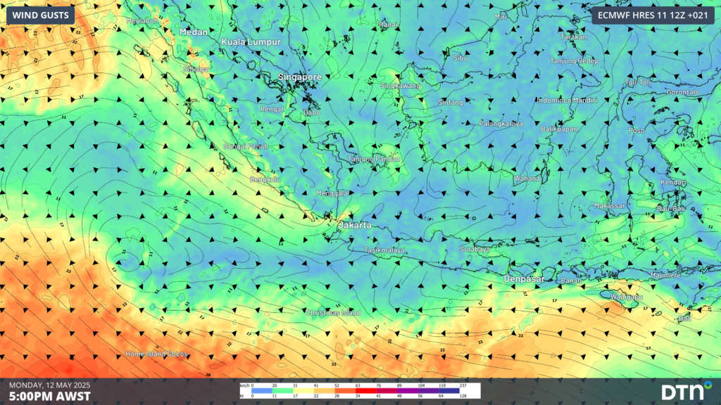
Image: 10m wind gusts at 5pm AWST on Monday, May 12 over Sumatra and Indonesia.
Heavy rainfall will continue to affect parts of Indonesia over the coming week as moist westerlies converge into the incoming easterly trades, especially over parts of Java. Weekly rainfall accumulations of 100-200mm are likely in some areas, as seen in the image below.
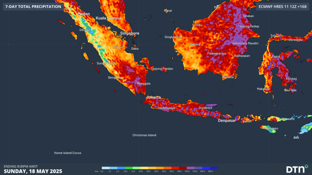
Image: rainfall accumulations to Sunday, May 18, over Indonesia.
Earthquakes affecting parts of Asia and the Pacific
Along with the wet season weather affecting these regions, increased earthquake activity has also been registered. Within the past 24 hours, significant earthquakes reported by Geoscience Australia include:
- 5.8 magnitude in Aceh, Indonesia
- 5.8 magnitude near Port Vila, Vanuatu
- 5.5 magnitude near Tonga
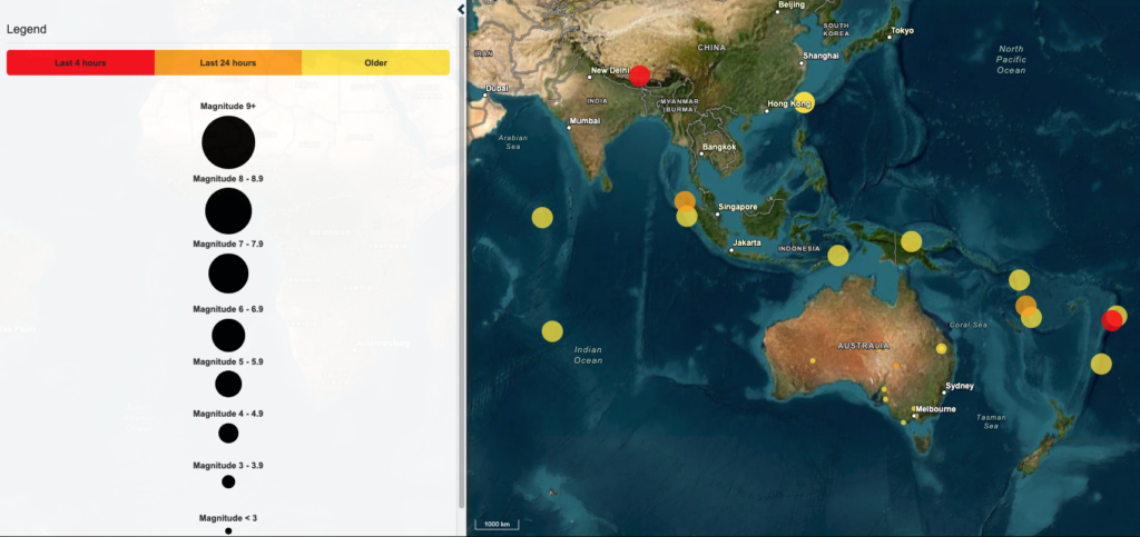
Image: recent earthquake activity across Australia, the south Pacific and Asia. Source: Geoscience Australia
No tsunami warning is currently active across Australia or the Indian Ocean as a result of these earthquakes, according to the Joint Australian Tsunami Warning Centre. Indonesia’s Aceh province was devastatingly affected by the 2004 Boxing Day Tsunami, with the earthquake epicentre just 200 kilometres off the west coast of Aceh. The magnitude of the 2004 earthquake had been estimated around 9, releasing nearly 50,000 times the energy of the recent earthquake.
How DTN APAC supports the Mining Industry
Are you protecting your mining business from the threat of extreme weather?
Miningzone, by DTN APAC, is the only weather tracking and alerting solution purpose-built for the resources sector.
As the climate shifts into unchartered territory, weather events could affect your mine with increasing force.
Miningzone is the proven and trusted turnkey solution – deployed at over 400 mines globally – offering you tailored forecasting and alerting systems to protect your valuable staff and assets.
Our integrated services are intuitive and user-friendly, providing you with the specific weather and blast data needed to gain a complete environmental picture.
You will have access to our lightning and severe weather tracking and alerts, EPA-approved blast dispersion modelling, thunderstorm tracking and high precision and site-specific forecasting, along with comprehensive reporting capacity.
Precise, market-leading data is delivered via multiple platforms including Weatherguard – our easy-to-use app – and can be fully integrated into your operational control or SCADA systems.
The tailored solution to drive your decisions.
DTN APAC’s Tropical Cyclone Services
DTN APAC gives you a comprehensive tropical cyclone service that helps your enterprise prepare for the worst in the best possible way.
As the climate delivers increasingly severe weather events, their potential to impact your business operations grows.
DTN APAC, specialises in industry-leading forecast, alerting and threat analysis of tropical cyclones, offering you expert, customised solutions when the weather turns wild.
Providing rapid-update forecast information, we alert you to any low-pressure system gaining power within your region and, unlike other providers, can track its development out to 7 days. This gives you the time to prepare and safeguard your staff, sites and assets.
You will have the most precise weather intelligence charting rainfall, wind speeds and potential storm surges to help you make critical decisions quickly. Whether it’s adjusting key work schedules, protecting your staff or securing your site, we have the alerting capability to keep you steps ahead of the storm.
We will support you, 24/7, keeping you informed and making your critical decisions easier.
For more information please visit our website or email us at sales.apac@dtn.com




