
Port and maritime operations across Australia’s East Coast could be disrupted by increased tropical cyclone activity in the Coral Sea and southwest Pacific Ocean over the next two weeks.
Meteorologists reference a large selection of Numerical Weather Prediction (NWP) models to forecast weather. A number of these NWP models are forecasting the development of tropical lows or cyclones in the Coral Sea and southwest Pacific over the next two weeks.
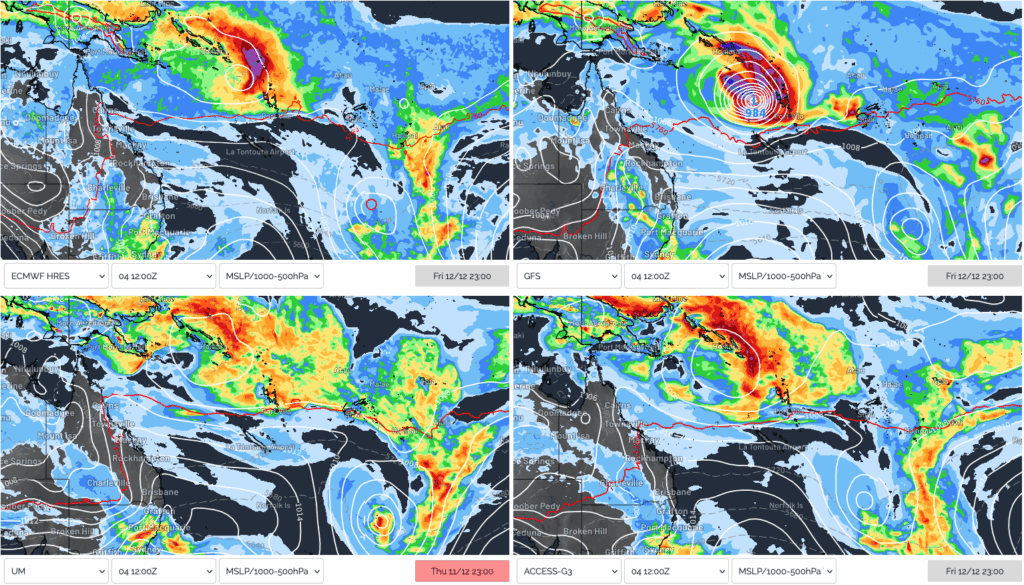
Image: Four major NWP models predicting tropical lows or cyclones being active east of Australia late next week.
This increased potential for tropical systems in the region is partly driven by an active phase of the Madden-Julian Oscillation (MJO) moving into the western Pacific region. The MJO causes an increase in cloud and thunderstorm activity when active over a region. This enhanced storminess can help create low pressure systems that can deepen into tropical cyclones.
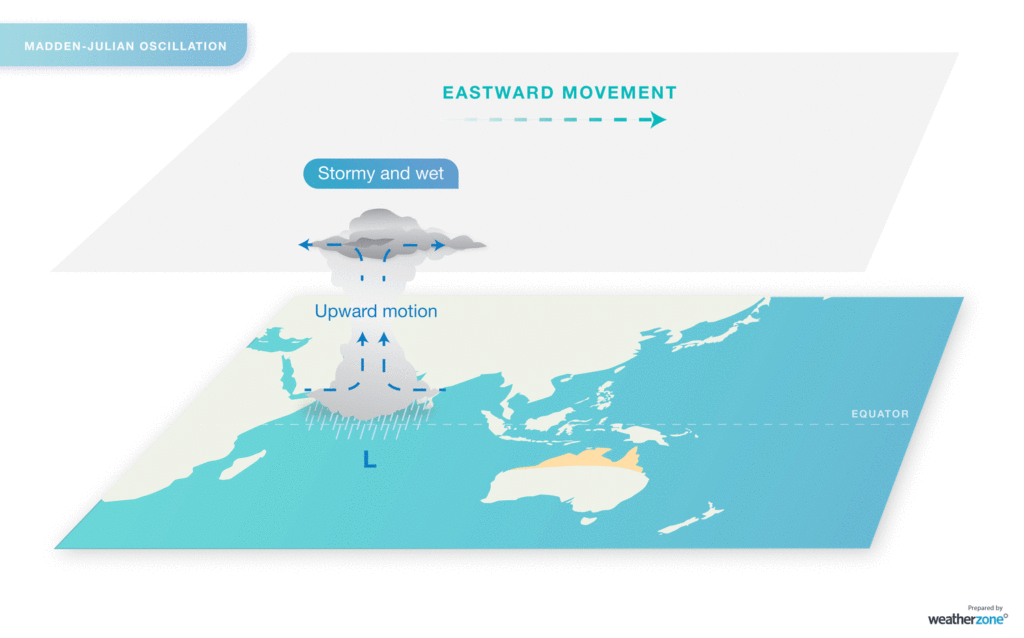
Image: Conceptual visualization of the MJO moving over the north of Australia, increasing thunderstorm, rain and tropical low activity. Source: Weatherzone.
Along with this active phase of the MJO, oceans are very warm across the Coral Sea and southwest Pacific. This is partly due to the weak La Niña conditions currently in place across the Pacific. These warm sea surface temperatures greatly increase the potential for tropical cyclone development, which requires waters warmer than 26.5°C. Currently oceans across the region are 2-3°C warmer than normal, with waters warm enough to support a tropical cyclone off southeast Queensland.
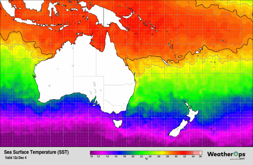
Image: Sea surface temperatures around Australia on Thursday, December 4, 2025.
How will Australian port and maritime be impacted?
Fortunately for Australian industries and businesses, the latest outlook produced by DTN APAC Meteorologist only suggests a low chance of a tropical cyclone being within the Australian region in the next 7 days. This product is reviewed daily by experienced Australian meteorologists who assess the risk of tropical cyclones being active, and potential impacts to clients, within each region.
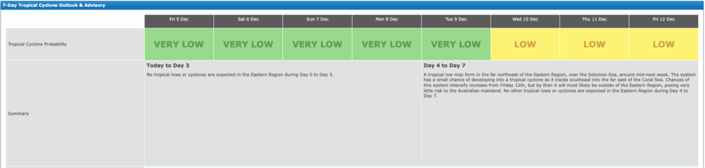
Image: DTN APAC Tropical cyclone 7-day outlook for the Eastern Region on Friday, December 5, 2025.
While our meteorologist forecast “it will most likely be outside of the Eastern Region, posing very little risk to the Australian mainland” and most models keep the systems well away from the mainland, tropical cyclones generate very large seas that radiate across the oceans, impacting Australia’s coastline from thousands of kilometres away.
Over the weekend, an area of low pressure will deepen near or just south of Fiji, potentially briefly reaching tropical cyclone intensity early next week before undergoing extra-tropical transition. While this system will remain 2,000-2,500 kilometres east of Australia, enhanced easterly trade winds around the low, with more powerful 35-45 knots winds near the core will generate a large area of swell generation, directed towards Australia.
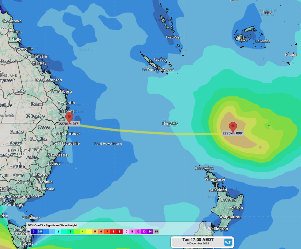
Image: DTN’s OneFX Significant Wave Heights reaching 5-6m generated on Tuesday, December 9, 2025.
Large seas generated by the low should reach 5-6m over parts of the southwest Pacific between Fiji and New Zealand early next week. This area of large waves being over 2,000 kilometres away from Australia’s East Coast will take about 3-4 days to propagate and reach our shores. Across this journey, the swell height will significantly decrease, but the wave period will increase.
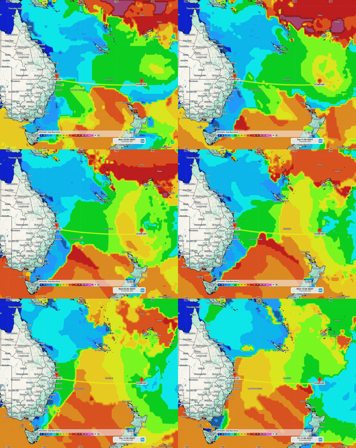
Image: DTN’s OneFX Peak Wave Period showing easterly swell propagating across the Tasman and lower Coral seas next week.
In deep open ocean waters, longer period swell travel faster than short period swell, so coastal parts of eastern Australia could see swell “front runners” as early as Thursday afternoon (December 11). These swell propagation leaders should come in with periods of 14 to 15 seconds, and small amplitudes of less than a metre. The bulk of the swell energy is then expected to fill into Friday, December 12, with coasts from NSW’s South Coast to Queensland’s K’gari experiencing 1 to 1.5m swell at 12 second periods, and up to 2m around NSW’s Northern Rivers and southeast Queensland.
The next system of interest that DTN APAC meteorologists are closely monitoring is the tropical low that could develop just south of the Solomon Islands from mid-next week. While most models feature a low developing in the far northeast of the Coral Sea next week, different model and model runs vary on the intensity and location of the system.
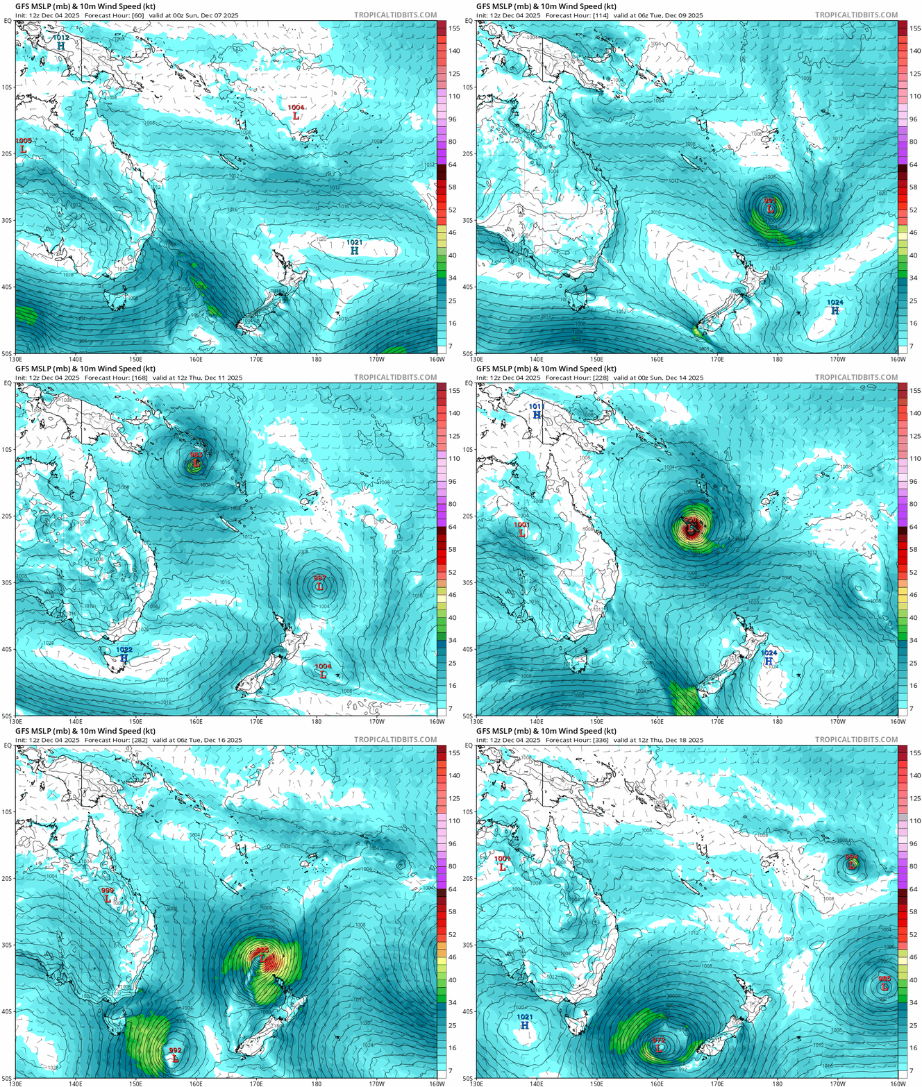
Image: GFS weather forecast of Mean Sea Level Pressure (MSLP) and 10m wind speeds between Sunday, December 7, 2025, and Thursday, December 18, 2025. Source: TropicalTidbits.com
The possible tropical cyclone could come within 1,000-1,500 kilometres of northeast NSW and southeast Queensland from around Saturday, December 13. The potential for significant easterly swell generation will greatly depend on the proximity, intensity and movement of the system. DTN meteorologists are assessing tropical cyclone risk and impacts for our customers on the daily, even when systems are thousands of kilometres offshore.
Why long period easterly swell can be so disruptive to port operations
Easterly swells are especially hazardous as they bypass the headlands and breakwalls that protect beaches, ports and harbours from the more typical south swells that impact NSW and southeast Queensland. This also enhances coastal erosion across beaches usually protected from south swells.
Long period “groundswell” energy often goes unnoticed underneath ships at sea, but can be highly disruptive as the energy surges into ports and harbours.
The “waves” of deep water energy surging into ports can cause ships to drag on their moorings and anchors. Seiching can also amplify this water movement as the energy sloshes within the port boundaries, increasing horizontal and vertical ship movements.
Using DTN APAC’s Operational Forecast Summary, ports operations are warned over a week away from the arrival of the long period groundswell, giving ample time to plan and alter operations around this week.

Image: DTN APAC Operational Forecast Summary showing the increasing groundswell risk on Friday, December 12, peaking on Saturday, December 13, in a simple, easy to understand, traffic light system.
Read more about how DTN APAC systems warn port operators of long period groundswells
How DTN APAC assists marine, ports and offshore industries
DTN APAC offers a comprehensive suite of services, refined through years of collaboration with the marine, ports and offshore industries, to optimise the safety and efficiency of your operations.
We work with you to understand your intrinsic operational challenges and customise high-precision forecasting, metocean and aviation services to your exact location and operational scope.
When working offshore, our solutions can underpin planning and safe execution for offshore oil and gas enterprises and wind farms. Our data can support your exploration, development, rig moving, shuttle tanker operations, and production and decommissioning phases. Whether your crews are on-site, being transported to shore, or diving to perform maintenance, we deliver tailored weather risk briefings to ensure you choose the optimal time to proceed.
DTN APAC’s trusted nowcasting and forecasting system, OpticastTM, allows you to rapidly respond to changing conditions offshore, en route and in port. We take your port topography and berth orientation into account, ensuring site-specific forecasts. For offshore oil & gas, wind farms, ports and logistics, we have your weather situational awareness covered, no matter where you are. We deliver real-time severe weather and lightning alerts to your team via your integrated dashboard: Portzone, and our Weatherguard app.
DTN APAC’s Total Lightning Network (TLN) ensures you avoid hours of unnecessary downtime by providing the most accurate technology in lightning detection and alerting. Safeguard your teams and assets with lighting and Dangerous Thunderstorm Alerts (DTAs), customised to your existing parameters and delivered in real-time across all devices in your network. You gain full spatial awareness of developing severe weather systems, allowing you to plan ahead and, where needed, execute your shutdown and evacuation procedures.
With extreme conditions slowing production and affecting infrastructure, safety and transport, trust us to deliver Australia’s most precise weather data and tailored insights, giving you decisive confidence when it’s most needed.
Learn more about our large range of industry leading products and services or email us at sales.apac@dtn.com




