A deep feed of moisture streaming from a monsoonal burst has brought widespread flooding to much of Queensland this week.
Moisture started streaming over the north of Queensland last week. With a 301mm rain day last week, Townsville has now set monthly station records with:
- 1198mm in February (nearly four times the monthly average of 312mm)
- 941mm in March (nearly five times the monthly average of 189mm)
- 2287mm this year already, 112mm away from the wettest year on record in 2000
As seen in the image below, tropical moisture from a developing monsoon burst started streaming into Queensland’s outback over the weekend and early this week, bringing heavy and widespread rainfall.
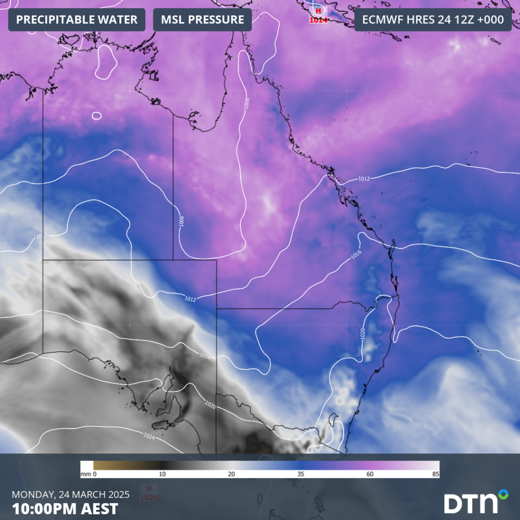
Image: Precipitable water streaming from the tropics over Queensland’s outback on Monday, March 24.
Widespread rainfall of 150-300mm has fallen over a broad and mostly flat area of western Queensland in the last few days. In the coming days and weeks, this immense amount of water will slowly funnel into the vast riverbed networks that occupy the Queensland outback. This flooding may move over the roads that criss-cross remote communities in the region, possibly leaving towns stranded for weeks to come.
In Queensland, major flooding is currently occurring for these rivers (as of 1pm AEST, Thursday, March 27):
- Thomson River at Stonehenge (higher than the January 1974 flood) and Jundah
- Barcoo River at Retreat from Friday (higher than the 1990 flood), and at Wahroongha and Glenlock
- Cooper Creek, possibly higher than the January 1974 flood at Windorah
- Paroo River at Eulo, moderate flooding likely at Hungerford
- Haughton River at Giru
- Bulloo at Quilpie, moderate flooding at Thargomindah
- Georgina River at Marion Downs
- Diamantina River to Diamantina Lakes
- Western River at Winton
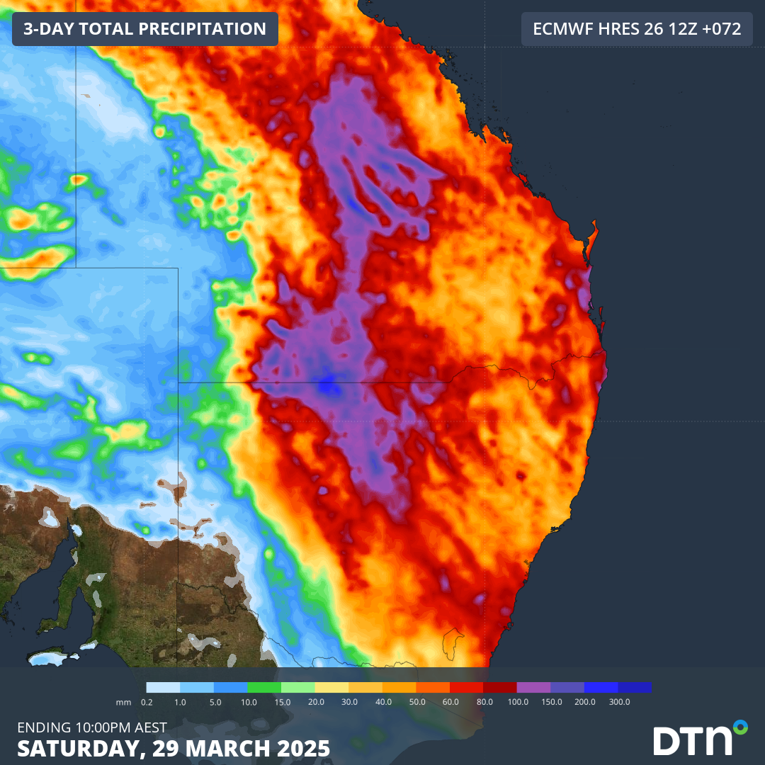
The image below shows that heavy rainfall will continue to affect broad parts of Queensland, extending into NSW, over the next 48-60 hours over the next few days. Further rainfall accumulations of 100-150mm, with pockets of 300-400mm, will exacerbate flooding over the Queensland outback, potentially reaching into parts of the east coast.

Image: Forecast rainfall over Queensland and NSW in the coming 3 days.
How the DTN APAC Flood Risk System works for your business
Using an advanced geofence technology, hundreds of virtual ‘weather stations’ are created for each chosen catchment areas determined by you. No matter how remote the catchment is, DTN APAC’s Oracle gives precise determination of rainfall intensity and accumulation. Oracle is a satellite-derived gridded nowcasting system, forecasting at a 1-2km resolution which updates every 5 minutes, giving it the upper hand on traditional 9-12km resolution models.
The image below shows how past, current and future rainfall is measured across each catchment in relation to thresholds defined by you. Alerts are raised when rainfall accumulations approach or breach maximum capacity threshold, giving you targeted visibility of active and future flood risk to inform operational responses.
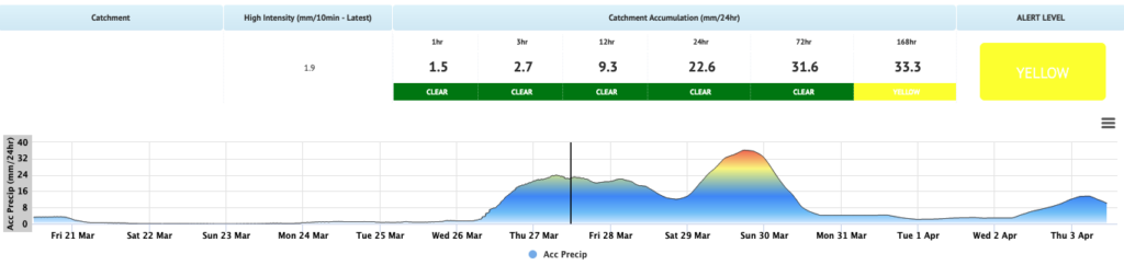
Image: The Flood Risk System dashboard giving visibility of past, current and future rainfall accumulations over the customised catchment.
Flood risk alerts are delivered via SMS, email and our industry app Weatherguard, providing immediate situational awareness. The risk system is easily integrated into any DTN APAC interface or existing dashboard. Rainfall data can be supplied to a third party to integrate hydrology and culvert alerts for your site, elevating risk visibility.
Be prepared for flooding, whether it directly impacts your safety on the ground, water supply, cuts off road access or rail lines, or restricts your access to assets.
To find out more about large range of products and services contact us at sales.apac@dtn.com


