Two unprecedented weather events during 2024 had a dramatic impact on wind power generation in the National Electricity Market, with the ebbs and flows keeping the market on its toes.
A combination of the 2022 Hunga Tonga–Hunga Haʻapai eruption and a rare Sudden Stratospheric Warming event were behind the substantial swings in Southern Annular Mode (SAM) and wind power during 2024.
SAM
One of the key generators of wind power are the cold fronts, low pressure systems and troughs that typically sweep from west to east across the south of the country. The climate driver that influences just how far north these systems pass is called the Southern Annular Mode (SAM).
Positive phases of SAM can decrease the frequency of strong wind events, with high pressure systems sitting over southern Australia forcing cold fronts and wind baring systems to the south of Australia. By contrast, negative phases typically increase the number of strong wind events, with the passage of cold fronts typically further north than normal over the south of the continent.
During 2024, the average SAM was predominantly positive, with a dip into the negative phase during July and August.
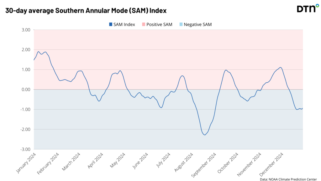
Apart from the winter dip, the SAM’s positive swings were generally greater than the negative ones, especially in the first half of the year, promoting lower wind across southern Australia.
The trends in the SAM had a direct impact on the wind power observed across the year in the NEM, with the lowest wind occurring during May when the SAM was positive and the highest in late August when the driver was negative.
The graph below shows the lowest NEM weekly wind power of 223 GWh occurred during the week beginning on the 20th May, while windiest week began on August 26 with 976 GWh/week observed.

Image: Wind power generation in GWh/week for the NEM during the past year. Source: OpenNEM
The 2022 Hunga Tonga–Hunga Haʻapai eruption
The low wind power and positive SAM between March and July 2024 was caused by a stagnant long-wave ridge pattern, leading to persistent high pressure in the Bight.
The image below shows substantial positive pressure anomalies over southern Australia during autumn and low pressure near Antartica. This was roughly equivalent to a 1 in 4000-year seasonal event (compared to the 1991-2020 climate), generating low wind power across the NEM.
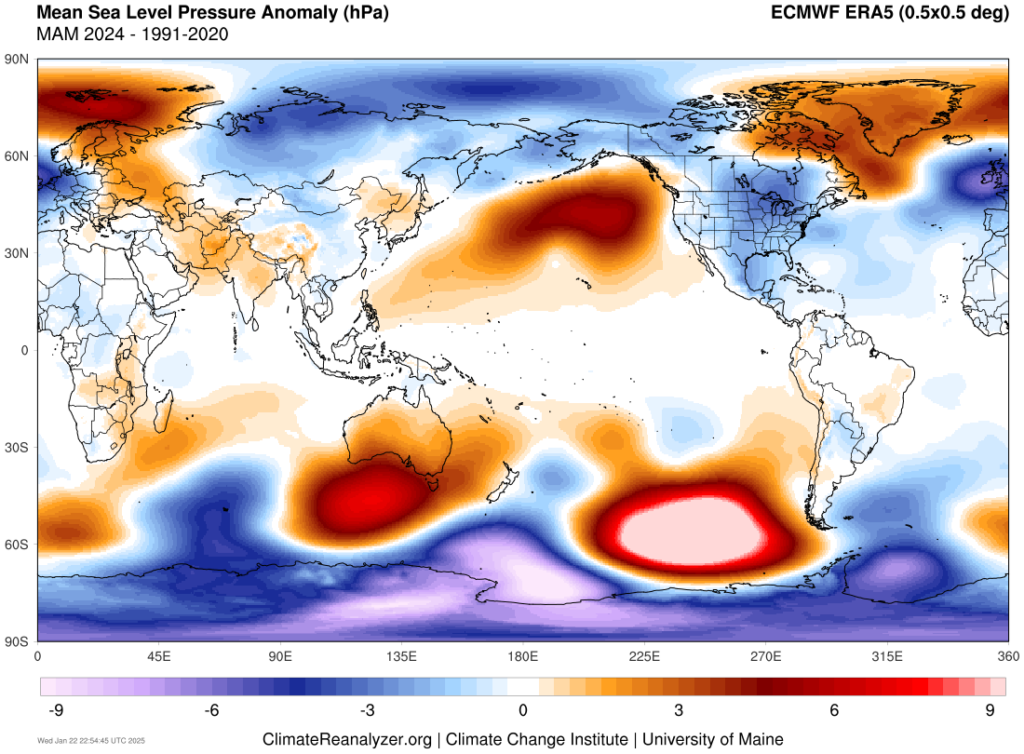
Image: Mean Sea Level Pressure Anomaly (hPa) for March, April and May 2024, compared to the 1991 to 2020 mean. Source: ClimateReanalyzer
This event was caused by Hunga Tonga-Hunga Ha’apai volcanic eruption in the Pacific on January 15, 2022. The volcano is underwater and released the equivalent of 60,000 Olympic swimming pools worth of water vapour into the stratosphere.
A study called “Long-term climate impact of large stratospheric water vapor perturbations” published in 2023, showed simulations of this water vapour creating an ozone hole between August and December 2023, which came into fruition.
The study showed that two years after the eruption that a positive SAM would develop, with the Antarctic Polar vortex shrinking and concentrating the CFCs generating the ozone hole.
Indeed, positive SAM developed and impacted Australia during the first half of 2024, reducing wind across southern Australia during this time.
The map below shows low wind power (blue shades) across southeastern Australia between March and June 2024, in response to the eruption and positive SAM.
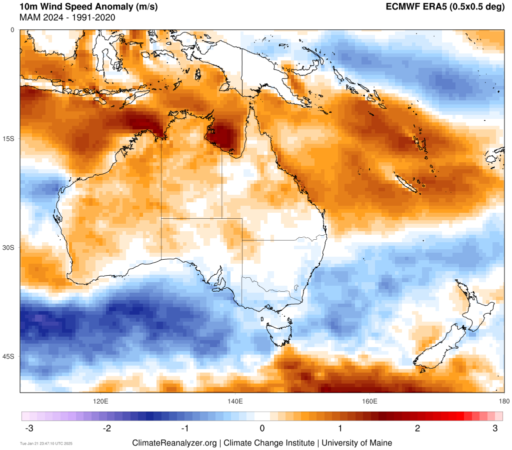
Image: 10m wind speed anomaly (m/s) for three months beginning in March 2024, compared to the 1991-2020 average. Source: ClimateReanalyzer.
Positive SAM also caused wetter conditions along the east coast of Australia, despite El Niño at play in the Pacific, which usually causes drier conditions across much of Australia.
Sudden Stratospheric Warming
This pattern of low wind and high pressure was abruptly interrupted by two rare Sudden Stratospheric Warming that occurred during mid-July and another in early August.
Sudden stratospheric warming (SSW) refers to an abrupt increase in air temperature in the polar stratosphere, which is a layer of the atmosphere roughly 30 to 40 km above Earth’s north and south polar regions.
Sudden warming in the polar stratosphere during winter or spring can disrupt the polar vortex, which can affect the behaviour of weather patterns across the planet’s high and mid-latitudes in the following weeks and months. While these events have been relatively frequent in the Northern Hemisphere in recent years, they are quite rare in the Southern Hemisphere.
Both stratospheric warming episodes caused a negative Southern Annular Mode (SAM) to develop in the Southern Hemisphere.
The maximum impact was seen in August 2024, with damaging winds, heavy rainfall and flooding impacting parts of southern Australia as a series of cold fronts and lows pummelled the region.
The images below show a significant shift to low pressure across the south of the country during August 2024, which increased wind power in the NEM.
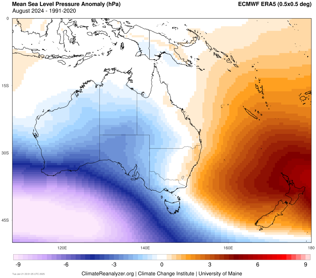
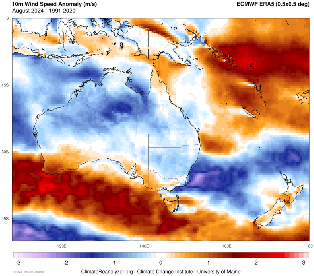
Image: Mean Sea Level Pressure anomalies (hPa) (top) and 10m mean wind speed anomalies (m/s) for August 2024 compared to the 1991 to 2020 average. Source:ClimateReanalyzer.
Annual wind 2024
Wind was mostly below average for Vic, SA, NSW and southern Qld, while above average wind was observed in Tas and northern Qld.
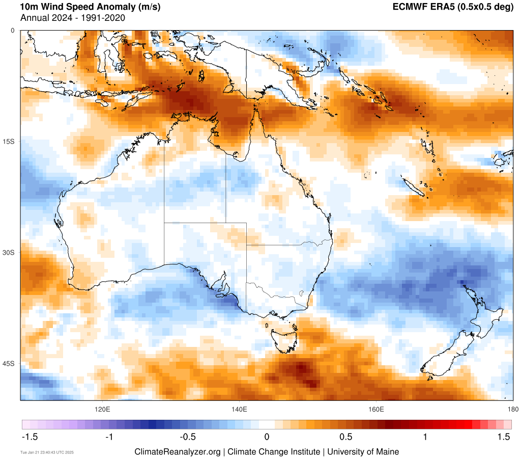
Image: 2024 wind speed (m/s) anomalies compared to the 1991 to 2020 average. Source: ClimateReanalyzer.
This pattern was caused by high pressure anomalies over southern Australia during 2024. A recent study has also found that low pressure systems and fronts are becoming less frequent across southern Australia due to higher pressure along our southern latitudes, which could see the NEM receiving reduced wind in the future.
Information on weather events like the above and how they could impact businesses are delivered to our clients in customised seasonal briefings. We deliver clear and comprehensive weather data, personalised risk assessments and briefings to you and your team, so that your critical decisions can be made with confidence.
You have our insights to rely on to see you through complex situations, minimising potential loss of profit and maximising the safety of your staff and assets. For more information contact us at sales.apac@dtn.com
Thumbnail credit: Istock/ Imagvixenz


