Rain is going to sweep across a broad area of Queensland and NSW during the next 4-5 days, with thunderstorms and flooding possible in some areas.
Moisture-laden air interacting with a low pressure trough has been causing cloud, showers and the odd thunderstorm to develop over eastern Australia on Wednesday.
The days of cloud and rain are likely to cause low solar output across eastern Australia.
On Thursday, rain and storms will become more widespread over western districts of NSW and across Queensland’s southern and central inland (figure 1).
Rain will also extend towards the coast in southern Queensland and northern NSW. Most of Thursday’s rain and storms are unlikely to be severe, although brief and isolated areas of heavy rain are possible.
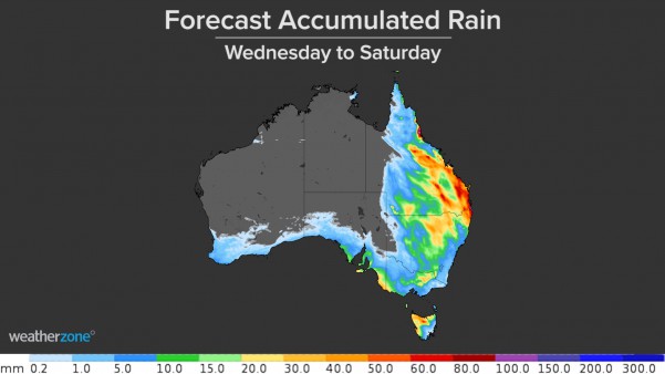
Figure 1: Forecast daily rainfall for Wednesday to Saturday.
The low pressure trough will shift further east on Friday, causing rain and storms to spread over NSW and southeast and central Queensland (figure 1). There is potential for moderate to heavy rain in some areas, most likely with slow-moving showers or storms.
Further persistent and locally heavy rain, along with some thunderstorms, will linger over central and southeast Queensland and far northeast NSW on Saturday as the low pressure trough moves closer to the Coral Sea. Some areas could see 30-50mm of rain on Saturday alone.
There is a risk of thunderstorms on the Queensland-NSW Interconnector (QNI) during Friday and Saturday, for those in the energy business.
The system will clear off Australia’s east coast on Sunday, allowing drier and sunnier conditions to return for most of eastern Australia.
Altogether, widespread falls of 10-20mm are likely over a broad area of Queensland and NSW between now and Sunday. Some areas of central and southeast Queensland and far northeast NSW could see 50-100mm from this system (figure 2).
Figure 2: Forecast accumulated rainfall from Wednesday to Saturday.
Of course some of this rainfall is likely to fall in areas that are not covered by radar. If you are a business without radar coverage, Weatherzone have you covered.
Oracle is a new ‘radar’ system, which enables users to see rain as it’s happening anywhere in the world. In addition to tracking current rain, Oracle also provides live forecasts of rainfall rates, lightning, and cloud for up to three hours in advance, for anywhere in the world.
It does this by feeding live satellite imagery, lightning data and nearby radar imagery into the forecast system. This cutting-edge technology was built in collaboration with our partner, Solcast.
Oracle is a more than adequate replacement for radar, but the genius of it is that it’s also a one-of-a-kind forecast system, delivering accurate forecasts for up to four hours.
For more information on Oracle or Weatherzone’s rainfall and solar forecasting capabilities, please contact us at apac.sales@dtn.com.


